A map showing a plan and additional field notes about water lots in the mouth of the Moira River and Bay of Quinte. The total area stretches from the mouth of the Moira River to south Front Street to Mary Street. Published by Thomas S. Ransom on July 31, 1961. The map was used for the installation of sewer lines. Scale: 1':100'.
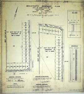
A certified reproduction of the "Registrar's Compiled Plan of part of East half of Lot #33, Concession IV.” The area includes; part of the east half of Lot # 33, Concession IV, Sidney Township, Lot # 33 being between Wallbridge Loyalist Road on West and Philburn Rd. Surveyed by Ransom and Watson, O. L. S. and signed March 9, 1967.
A certified reproduction of the "Subdivision of part of Lot # 11, East of Gilbert St. Reg'd Plan No. 171, “May Ave”' owner- Maurice H. Rollins Construction Ltd.” The area includes; Lots # 1 to 5 East of Gilbert St. and South of May Avenue. Surveyed by Thomas S. Ransom, O. L. S., of Ransom & Watson, O. L. S. and signed January 28, 1964.
A certified reproduction of the "Registrars' Compiled Plan. Part of Lot # 25, Concession 1 and Broken Front concession Township of Sidney.” The area includes; the Bay of Quinte to the Canadian National Railway, being along the east side of Montrose Road. Surveyed by Thomas S. Ransom, O. L. S. of Ransom & Watson, O. L. S. and signed March 30, 1965.
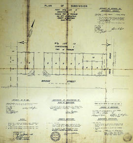
A certified reproduction of the "Subdivision of part [the] West ½ of Lot # 13, Concession 1, Township of Thurlow now Belleville.” The area includes; Lot # 1 to 10 and Blocks A & B north of Bridge St. East and west of Haig Road. Surveyed by Thomas S. Ransom, O. L. S. (of Ransom & Watson, O. L. S.) and signed May 17, 1965.
A certified reproduction of the "Subdivision: Ponton Park, part of Lots # 37 & 38, Concession 1...Township Sidney, now [the] City of Belleville.” The area includes; Sidney Street on the east, Nisbet Avenue on the west, the Bay of Quinte on the south and north to Leland Drive. Surveyed by Thomas S. Ransom, O. L. S. and signed September 14, 1965.
A certified reproduction of the "Registrar's Compiled Plan of [the] west half Lot # 31, Concession VI, Township of Sidney.” The area includes; Lots # 1 to 52, Concession VI, and north from the Road Allowance between Concession V & VI to Hwy 14. Surveyed by Ransom & Watson, O. L. S. and signed September 7, 1965.
A certified reproduction of the "Subdivision of north half of Lot # 13, Reg'd Plan No. 769, County of Hastings, City of Belleville, formerly Township of Thurlow, [for] owners Ernest A. and Ada C. Hughes.” The area includes; Lots # 1,2, 3, south of Auburn and east of Sidney Streets. Surveyed by Thomas S. Ransom of Ransom & Watson, O. L. S. and signed July 24, 1965.
A certified reproduction of the "East Park Subdivision, part of east half of Lot # 13, Concession 1, formerly Township of Thurlow, now Belleville - owner Lambert Rollins Construction.” The area includes; Lots # 1 to 47, Block A-C, east of Haig Road, with Bridge Street East, Joyce Crescent, Freemont Road. Surveyed by T. S. Ransom O. L. S. (of Ransom & Watson, O. L. S.) and signed April 21, 1965.
A certified reproduction of the "Northgate Subdivision - part of Lot # 3 east of North Park St. Gov't Plan (Township of Thurlow), City of Belleville. Owner Maurice H. Rollins Construction Ltd.” The area includes; subdivision east of North Park Street, Lots # 1 to 17 on Craig Street and Blocks A-G. Surveyed by Thomas S. Ransom, O. L. S. and signed February 21, 1962.
A certified reproduction of the "Applegrove Acres Subdivision - part of Lot # 10, Concession 1, formerly Township of Thurlow, now Belleville. Owner Charles W. Lambert.” The area includes; north Bridge Street East, with lots on Plaza Square & Bridge Street East. Surveyed by Thomas S. Ransom, O. L. S. and signed April 11, 1962.
A certified reproduction of the "Subdivision of part Lots # 10 and 11, Reg'd Plan No. 63, Township of Thurlow, now City of Belleville, owner Demille Construction Ltd.” The area includes; north of Victoria Avenue and west of Herchimer Avenue, Lots # 1 to 30 on Leslie Drive and Victoria Avenue. Surveyed by Thomas S. Ransom, O. L. S. and signed May 25, 1962.
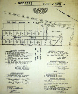
A certified reproduction of the "Subdivision of part of the North half of Lot # 24, Concession IX, Township of Sidney, now in [the] village of Stirling.” The area includes; Lots # 1 to 21 and Blocks A, B, C on Rogers Drive and Elizabeth Street being north half Lot # 24, Concession IX, Township of Sidney. Surveyed by Thomas S. Ransom, P. L. S. and signed June 1, 1962.
A certified reproduction of the "Subdivision Eastview Heights, part of Lot # 13, Concession 1, Township of Thurlow now City of Belleville.” The area includes; north of Victoria Avenue being Lots # 1 to 25, Blocks A-B laid out on Edge Hill Road, Kingsway Court, Victoria Avenue, and Haig Road. Surveyed by Thomas S. Ransom, O. L. S. and signed May 17, 1963.
A certified reproduction of the "Subdivision of West Park Village, part of Lot # 38, Concession 2, Township Sidney, now City of Belleville, owner Charles Lambert, L & M. Developments” The area includes; Lots # 1 to 185 and Block A to L, north from C. N. Railways to Cascade Boulevard, to the boundary line between Lots # 37 & 38, Sidney Township. Surveyed by Thomas S. Ransom, O. L. S. and signed August 23, 1963.
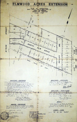
A certified reproduction of the "Subdivision “Elmwood Acres Extension”, part [of] Lots # 5 & 6, Reg'd Plan No. 64, Town of Trenton- owner B E P Construction Ltd.” The area includes; west of town limits for the town of Trenton, west to Byron Street, Lots # 1 to 23 and Blocks A, B, C on North Elm Drive and Nelles Ave. Surveyed by Thomas S. Ransom, O. L. S. and signed February 14, 1963.
A certified reproduction of the "Bell Subdivision - part of Lot # 38, Concession 2, north of College Street West, Township of Sidney, now City of Bellevile - owners Edgar H. Bell and Gloria J. Bell.” The area includes; north of College Street West and west of Sidney Street Lots # 1 to 5. Surveyed by Ronald Benn, O. L. S. and signed December 23, 1963.
A certified reproduction of the "Subdivision of part of Block 3, Reg'd Plan No. 25, City of Belleville, prepared for B. E. P. Construction Ltd.” The area includes; north from C. N. Railway to Evans St. and west from North Front Street to Coleman Street. Surveyed by Thomas S. Ransom, O. L. S. of Ransom & Watson, O. L. S. and signed February 20, 1963.
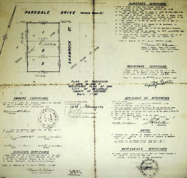
A certified reproduction of the "Subdivision of Lots # 6 & 7 Reg'd Plan No. 1048, owners- Maurice H. Rollins Construction Ltd.” The area includes; Lots 2-3, south of Parkdale Drive and west of Shamrock Street being east of Sidney Street. Surveyed by Thomas S. Ransom, O. L. S. and signed February 20, 1964.
A certified reproduction of the "Subdivision of part of Lot # 22, Reg'd Plan No. 797, City of Belleville, owner- West Park Construction Belleville Ltd.” The area includes; Lots 1 to 3 west of Lemoine Street and north of Auburn Street. Surveyed by Thomas S. Ransom, O. L. S. and signed June 1, 1964.