A map of heritage buildings, using Goad's Fire Insurance Maps from 1904-1908, in the East Hill area of Belleville, Ontario. Prepared by the Local Architectural Conservation Advisory Committee in 1985. A colour chart dictates red for first priority; yellow for important to the street scape; blue for lost heritage; green for open areas.
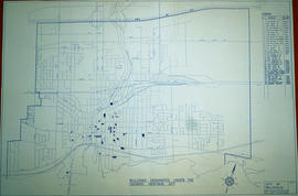
A map of the Buildings Designated under the Ontario Heritage Act in Belleville, Ontario. Created by the Heritage Belleville Committee on November 22, 1985 and revised February 14, 1994. The area includes; the Bay of Quinte north to Highway 401 with designations in the area between Sidney Street and McDonald Avenue.
A study of Front Street Heritage Buildings. The study was completed in 1980 by the Local Architectural Conservation Advisory Committee and funded by the Summer Youth Employment Program. A reference map (in two sheets) corresponds to drawings of buildings labelled A-U.
A research project completed by the Heritage Belleville Committee from October 1993 - February 1994. The project researched designated (red) and non-designated (blue) heritage properties in the West Hill area of Belleville, Ontario.
Tape labelled "Hastings County Administration Building, 235 Pinnacle Street, Belleville, Ontario, taped by Heritage Belleville, April /96". The video is 13 minutes and 30 seconds in length, and consists of a visual and audio survey by an unidentified female narrator of paintings and plaques inside and outside the Hastings County Court House and Administrative Building on April 4th, 1996.