A map showing concessions and lots of Cashel Township, Hastings County. Circa 1869. 13 advertisements for companies are present on the left-hand side. Published by Macleod and Carre, Engineers and Surveyors. Scale: 1:63,000. Dimensions: 29.0cm x 33cm. Map was created from Government plan.
Donated from the Col. W. N. Ponton Estate. Penciled notes on map show Ponton family's interest in mining, especially after the Eldorado Gold Rush in 1866.
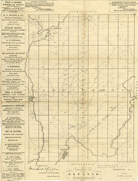
A map showing concessions and lots of Elzevir Township, Hastings County. Circa 1869. 16 advertisements are present on the left-hand side. Published by Macleod and Carre, Engineers and Surveyors. Scale: 1:63,000. Dimensions: 29.0cm x 37.5cm.
A map showing concessions and lots of Huntingdon - Madoc Township, Hastings County. Circa 1869. 30 advertisements for companies surround the map. Published by Macleod and Carre, Engineers and Surveyors. Scale: 1:63,000. Dimensions: 34.0cm x 37.0cm. Map was created from Government plan.
Donated from the Col. W. N. Ponton Estate. Penciled notes on map show Ponton family's interest in mining, especially after the Eldorado Gold Rush in 1866.
Map showing concessions, traveled roads and lots of Marmora Township, Hastings County. Areas of gold mines are also charted. Scale: 1 mile : 1 inch. Published by MacLeod & Carre Engineers and Surveyors in Belleville, Ontario (Canada West). Local advertisements surround map.
Received from the Public Archives of Canada on 3 May 1971.