Mostrar 136 resultados

Descrição arquivística
Map collection Buildings and structures Com objeto digital
Previsualizar a impressão Hierarchy Ver:

Research Project on Heritage Buildings in West Hill

  • CA ON00156 M/M440-2869
  • Item
  • Oct 1993 - Feb 1994
  • Parte de Map collection

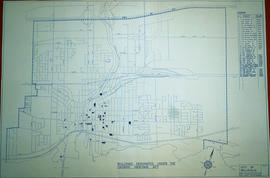
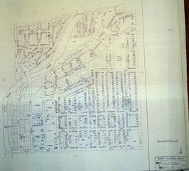
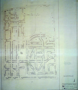
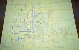
A research project completed by the Heritage Belleville Committee from October 1993 - February 1994. The project researched designated (red) and non-designated (blue) heritage properties in the West Hill area of Belleville, Ontario.

Donated by Heritage Belleville in 2017.

Sem título

Buildings Designated under Ontario Heritage Act

  • CA ON00156 M/M440-2973
  • Item
  • 22 Nov 1985 - 14 Feb 1994
  • Parte de Map collection

A map of the Buildings Designated under the Ontario Heritage Act in Belleville, Ontario. Created by the Heritage Belleville Committee on November 22, 1985 and revised February 14, 1994. The area includes; the Bay of Quinte north to Highway 401 with designations in the area between Sidney Street and McDonald Avenue.

Donated by Heritage Belleville in 2017.

Sem título

Belleville's Heritage Map of East Hill

A map of heritage buildings, using Goad's Fire Insurance Maps from 1904-1908, in the East Hill area of Belleville, Ontario. Prepared by the Local Architectural Conservation Advisory Committee in 1985. A colour chart dictates red for first priority; yellow for important to the street scape; blue for lost heritage; green for open areas.

Donated by Heritage Belleville in 2017.

Sem título

City of Belleville Map with Property Boundaries in 1981

A map of the City of Belleville, including property boundaries, waterways and roads. From the Moira River in the east to the Bay of Quinte south and CNR & North Front Street in the north to Avondale Road in the west. Map composed by the Quinte Planning Board and dated October 1, 1981. Scale 1:4800.

Donated by the Heritage Belleville Committee in 2017.

Sem título

Front Street Heritage Building Study

A study of Front Street Heritage Buildings. The study was completed in 1980 by the Local Architectural Conservation Advisory Committee and funded by the Summer Youth Employment Program. A reference map (in two sheets) corresponds to drawings of buildings labelled A-U.

Sem título

South City of Belleville Map with Property Boundaries in 1976

A map of the City of Belleville, including property boundaries, waterways and roads. House numbers are also included. From Bay of Quinte north to Bridge Street East and from the Moira River east to Foster Avenue. Map composed by the Quinte Planning Board and dated February 23, 1976. Scale 1:2400.

Donated by the Heritage Belleville Committee in 2017.

Sem título

Central City of Belleville Map with Property Boundaries in 1976

A map of the City of Belleville, including property boundaries, waterways and roads. House numbers are also included. From Bridge Street East north to Station Street and from the Moira River east to Bleecker Avenue. Map composed by the Quinte Planning Board and dated February 23, 1976. Scale 1:2400.

Donated by the Heritage Belleville Committee in 2017.

Sem título

East City of Belleville Map with Property Boundaries in 1976

A map of the City of Belleville, including property boundaries, waterways and roads. House numbers are also included. From Bridge Street East north to Station Street and from the Bleecker Avenue east to Herchimer Avenue. Map composed by the Quinte Planning Board and dated February 23, 1976. Scale 1:2400.

Donated by the Heritage Belleville Committee in 2017.

Sem título

Corporation of Thurlow Map of Roads

A map from the Corporation of the Township of Thurlow showing Ontario Hydro lines, concessions and additional country roads. Circa 1970.
Donated by the City of Belleville.

Corporation of Thurlow Map of Wards

A map from the Corporation of the Township of Thurlow showing the ten ward boundaries. Circa 1970.
Donated by the City of Belleville.

Map of Belleville's Growth from 1816-1965

A copy of a map detailing the temporal and spatial sequence of Belleville's growth from a village to a town and then a city. The different stages of growth (see legend) and administrative boundaries are outlined. Created by the Belleville and Suburban Planning Board in July 1967.

Sem título

Street plan of the City of Belleville 1965

A map detailing local streets, schools and their respective names, in Belleville, Ontario. Published by the Belleville and Suburban Planning Board in October 1965. Scale 1:9500.

Sem título

Property Boundaries and Topographics in Belleville 1964

A map of the City of Belleville, including property boundaries, buildings and topographical features. Composed by the Belleville and Suburban Planning Board. Photography for maps completed on April 26, 1964 by Pathfinder Air Surveys Ltd.

Donated by the Belleville Public Library in 2014.

Sem título

Proposed Reconstruction of Corby Park in Belleville

A plan of the "Proposed Reconstruction of Corby Park, in Belleville, Ontario." Composed by the Belleville & Suburban Planning Board and the Belleville Board of Parks Management in September 1964.

Donated by the Heritage Belleville Committee in 2017.

Sem título

Pathfinder's Map of Belleville 1963

A map of the City of Belleville in Hastings County, Ontario. Composed and published by Pathfinder Air Surveys Ltd., in 1963.
Insets include:
1) Street index
2) Industries index
3) Businesses and services index
4) Legend
5) List of cities with Pathfinder map suppliers
6) Survey information

Sem título

Map of the City of Belleville 1963

A map of the City of Belleville, Ontario in November 1963. The developed streets are pictured. Local water ways including the Bay of Quinte and the Moira River are also present.

Plot Plan in the City of Belleville in 1960

A plan of a plot in the City of Belleville. Some of the buildings on site include Zellers, A and P, Reitmans. The plot is located between Dundas Street and Bridge Street. Published December 30, 1960 by Principal Investments Ltd., General Contractors.

Donated by the Belleville Public Library in 2014.

Survey Plan and Physical Features of Belleville

  • CA ON00156 M/M440-1309
  • Item
  • 8 Jan 1959 - 23 Mar 1959
  • Parte de Map collection

A "Plan of Survey showing Physical Features" detailing city lots, buildings and streets in Belleville. Ontario. By John T. Ransom, Ontario Land Surveyor on January 8, 1959 and revised on March 23, 1959. Scale: 1 inch to 20 feet.

Text: [based on the] Government Plan 1816; [including] Lots # 28 and part of Lots # 27 and 29 East of Pinnacle Street and Lot # 28 and part of Lots # 27 and 29 West of Church Street.

Donated by Tom Ransom, Belleville, surveyor and son of the author.

Sem título

Zoning Map of Belleville 1959-1970

A map showing, primarily, zoning limits within the City of Belleville. The limits are coloured in crayon and can be referenced on the legend (left). The map was first created c. 1959 (as written in pencil). However, more recent revisions were made June 4, 1970. Scale: 1:12,000. Additional information about by-laws is available on the map's border.

Note the two names listed on the top left corner: K. Murray and D. Williams - possible authors or owners.

Resultados 1 a 20 de 136