- CA ON00156 TW
- collection
- 1881-2007
Records of Wollaston Township in Hastings County, including minute books, by-laws, Council resolutions and collectors' cash books.
Sans titre
15 résultats directement liés Exclure les termes spécifiques
Records of Wollaston Township in Hastings County, including minute books, by-laws, Council resolutions and collectors' cash books.
Sans titre
Wollaston Township – Coe Hill; notes used by Boyce in writing Historic Hastings
Fait partie de HCHS Textual Records collection: Files 3000 to 3499
File contains notes and excerpts with a brief history of Wollaston Township, titled "History of Coe Hill".
Wollaston Twp – Field notes by Quintin Johnston, 1857 & John Snow, 1864
Fait partie de HCHS Textual Records collection: Files 3000 to 3499
File contains copies of the original field notes of the Township of Wollaston by Quintin Johnston 1857; and Returns of the survey of the Township of Wollaston, Crown Lands, 6-October-1863 by John Allen Snow.

Returns of the Survey of the Township of Wollaston - Cover
Fait partie de HCHS Textual Records collection: Files 3000 to 3499
Cover page of the Returns of the Survey of the Township of Wollaston, prepared under the direction of Ontario land surveyor John Allen Snow.
Sans titre
Limerick Township : petition to separate from Tudor Township
Fait partie de HCHS Textual Records collection: Files 1500 to 1999
File contains a manuscript report of the Hastings County Council Committee of Whole, 1868, finding against a petition for the separation of Wollaston and Limerick Townships from Tudor Township and the creation of separate township councils.

Map of Mineral Deposits in Coehill and Jenkins
Fait partie de Map collection
"Coehill and Jenkins Irone Ore Deposits, Lots 15, 16, 17, 18, Concession 8, Township of Wollaston, Hastings County, Ontario."
A map published by the Department of Mines of Canada, in 1911, showing contour lines, magnetic intensities and other physical features. Surveyed by E. Lindeman.
Donated by Nick January in 2016.
Sans titre

Fait partie de Map collection
A blueprint reproduction of a map of Wollaston Township in Hastings County, Ontario. The map features the names of neighboring townships, lot and concession numbers, rivers, lakes, and the Central Ontario Railway. Original map circa 1880. Scale 40 chains to an inch.
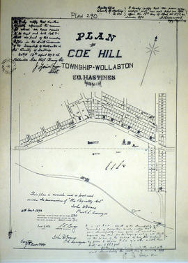
Plan of Coe Hill in the Township of Wollaston
Fait partie de Map collection
A certified reproduction of the "Plan of Coe Hill, Township of Wollaston, Lot # 15, Concession 9.” Surveyed by John D. Evans, P.L.S., and signed December 31, 1892.
This copy was made in 1972 of plan #290, as registered in the Hastings Land Registry Office.
Donated by Walter I. Watson, P. L. S.
Sans titre

Subdivision of part of Lot 15 in the village of Coe Hill
Fait partie de Map collection
A certified reproduction of the "Subdivision of part of Lot # 15, Concession VIII and IX, Township of Wallaston.” The area survyed includes; Coe Hill Village, both sides of High Street between Centre Street and Railway Street. Surveyed by Charles D. Campbell, O. L. S. of J. Walter Evans & Co. Engineers & Surveyors. Signed February 15, 1927.
This copy was made in 1972 of plan #549, as registered in the Hastings Land Registry Office.
Donated by Walter I. Watson, P. L. S.
Sans titre
Fait partie de HCHS Textual Records collection: Files 3000 to 3499
File contains several newspaper articles; one from The Ontario Intelligencer, dated July 20, 1933 and titled "The Old Church, the Ridge, In Wollaston Township"; from the Intelligencer, dated May 24, 1957 titled "Mrs. H.M. Hoard, Wollaston, Heads Assessors' Class"; one dated March 23, 1960 titled "Find of Copper Extends Into North Hastings".
Tudor, Cashel, Wollaston and Limerick Townships Voters Lists, 1875
Fait partie de HCHS Textual Records collection: Files 3000 to 3499
File contains photocopied printed voters lists for the United Townships of Tudor, Wollaston, Limerick and Cashel, 1875 by male heads of households. Lot and concession locations are listed.
Tudor, Wollaston & Limerick Townships : Certificate of Reeve
Fait partie de HCHS Textual Records collection: Files 3000 to 3499
File contains a manuscript certificate of reeve, dated 15 January 1866, confirming William H. Carpenter as duly elected reeve for the united townships of Tudor, Wollaston and Limerick Townships.
McGee, William Adult Writers Contest
Fait partie de HCHS Textual Records collection: Files 3500 to 3916
Entry for an adult writer's contest by William R. McGee. Includes sketches. 32 pages.
Hastings County J.P. Oaths of Qualification 1860 Folder F
Fait partie de HCHS Textual Records collection: Files 1000 to 1499
File contains affidavits signed in the 1860s for various individuals in Tudor, Thurlow, Tyendinaga, Wollaston, and Trenton taking office.
Hastings County : colonization roads
Fait partie de HCHS Textual Records collection: Files 1000 to 1499
File contains a petition to the Warden and Council of Hastings County from residents of Tudor, Wollaston, and Limerick Townships concerning the condition of existing roads and the need for a new road and bridge