Tyendinaga, Township of

Taxonomie

Code

Bereik aantekeningen

Toon aantekening(en)

Hiërarchische termen

Tyendinaga, Township of

Tyendinaga, Township of

Gelijksoortige termen

Tyendinaga, Township of

Verwante termen

Tyendinaga, Township of

77 Archivistische beschrijving results for Tyendinaga, Township of

77 results directly related Exclude narrower terms

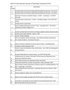
Ontario Hydro Aerial Photograph of Tyendinaga Township

  • CA ON00156 M/M470-2699 - 2703/2701
  • Stuk
  • 10 Sep 1973 - 27 Jul 1976
  • Part of Map collection

An aerial photograph of Tyendinaga Township, Concession 3 (Map # TD 19685Z). The photo includes Concession 3, Lots # 1 to 26 including proposed Hydro right of way and landowners names and instrument numbers Photographed on September 10, 1973 and annotations made July 27, 1976. Scale 1 inch = 200 feet.
For the Ontario Hydro Route and site Selection Division, Orthophoto R/W Selection Plan Lennox G. S. - Oshawa Area T. S. Aerial View.
By J. E. Clements- photogrammetric production officer; D. Crozier- chief draftsman; J. Sedgwal- project engineer; C. E. Bishop- Sr R/W planning engineer.

Zonder titel

Ontario Hydro Plan of Lots 31-40 in Tyendinaga Township

Plan showing Tyendinaga Township, Part of Lots # 31 to 40, concession 2 North range, Ontario Hydro proposed right to way (Map # TD30189Z). For Ontario Hydro, Design and Construction Branch, Surveys and Mapping. Scale 1 inch = 200 feet. Drawn by R. Sweeney, R. A. Schan, O .L. S.

Zonder titel

Aerial Photograph of Tyendinaga Township

  • CA ON00156 M/M470-2781 - 2794/2794
  • Stuk
  • 10 Sep 1973 - 25 Aug 1976
  • Part of Map collection

An aerial photograph of Tyendinaga Township, Map # TD19684Z01. The total area covered includes, Lots # 22-40, Concession 2, Lot # 22-31, Concession 3 - showing orthophoto right of way Selection Plan. For Ontario Hydro - Route & Site Selection Division. Aerial photo taken on September 10, 1973 and published August 25, 1976. Scale: 1 inch = 200 feet.

Map 3 from the Hydro Comission Route Inquiry

A map studying the proposed routes for power transmission from Lennox to Oshawa. The area covers from West Oshawa, East Mount Pleasant Jct. North Rice Lake & South Lake Ontario.

Zonder titel

Plan of Hastings for Hastings Directory

A map of Hastings County outlining townships:
Marmora, Lake, Madoc, Tudor, Grimsthorpe, Elzevir; Rawdon, Huntingdon, Hungerford, Sidney, Thurlow, Tyendinaga - as well as the northern townships.
Inset is "the Village of Marmora." Surveyed by H. A. F. Macleod, C.E. and P.L.S. Published by W. A. Little Lith., Montreal in the 1864-1865 copy of the Hastings Directory . Scale: 1:190,000.

Zonder titel

Map of Hastings County in 4 sections

A map of Hastings County outlining townships from the Bay of Quinte in the south, to Wallaston, Limerick and Cashel in the north.
Map is in four sections. Scale: 3 miles : 1 inch. Original map is dated 1894. Photocopy from the Archives of Ontario.

Map of the Counties of Hastings and Prince Edward

A "Map of the Counties of Hastings and Prince Edward." In 1898, the lots, concessions, churches, schools and mines are shown of the townships in Hastings and Prince Edward. Scale: 1.5 miles to an inch. Published by the Canadian Map Publishing Company in Hamilton, Ontario, for the Belleville Sun. Revised by Henry Carre, C.E. Inset is the map of North Hastings, scale 400 chains to an inch.

Zonder titel

Plan of village of Milltown in the Township of Tyendinaga

A certified reproduction of the Plan of part of Lot # 10 in 1st Concession of "Tyandinaga" Township, south of Road and the vilalge of Milltown. Depicted: homes, foundry, grist mill, saw mill, forge wells, lkiln and bounded by the Grand Trunk Railway. Surveyed by J. J. Haslett, P.L.S. in 1860.

This copy was made in 1972 of plan #97, as registered in the Hastings Land Registry Office.

Donated by Walter I. Watson, O.L.S.

Zonder titel

Family and Farm Histories

Histories of farming families in Tyendinaga Township, with photographs of some farm properties.

Index of contents:
Richard & Sam Tripp
Mr & Mrs James Osborne
Mr & Mrs Joseph Forestell
Mr & Mrs John Milligan
Mr & Mrs Allan King (former Jacob Eaton property)
Mr & Mrs Newton Demille
Mr & Mrs Les Gnaedinger
Gerald & Orville Stratton
Mr & Mrs Ron Graham
Mr & Mrs Earl Badgley
Mr & Mrs Roy Badgley
Mr & Mrs Harold McMechan
Mr & Mrs Donald McLaren
Mr & Mrs Fred Robinson
Mr & Mrs Clare Weese
Mr & Mrs Larry Plews
Mr & Mrs John Blatherwick
Mr Jack Farrell (blacksmith)

Pictures:
Lonsdale Station
Farm Homes - J. Milligan, M. Dawson, J. Colson, A. Haight, Earl Lansing, S. Demille
Mr & Mrs Vernon Pascoe's store

Churches

Photographs, typescript histories, and press clippings relating to Tyendinaga Township churches.

Melrose United Church (burnt down and rebuilt in 1962)
Salem United Church (closed 1951, torn down 1954)
Shannonville United Church (closed 1967)
Lonsdale United Church (closed 1967)
Holy Name of Mary Church, Marysville
St. Charles Borromeo, Read

Resultaten 1 tot 20 van 77