Tudor, Township of

Taxonomy

Code

Scope note(s)

Source note(s)

Display note(s)

Hierarchical terms

Tudor, Township of

Tudor, Township of

Equivalent terms

Tudor, Township of

Associated terms

Tudor, Township of

32 Archival description results for Tudor, Township of

32 results directly related Exclude narrower terms

Tudor Township : Provincial Land Surveyors' notes

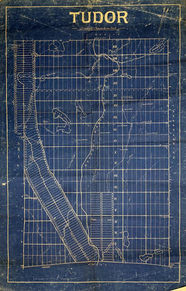
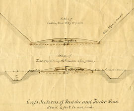
File contains a copy of manuscript field notes by W.H. Deane, Provincial Land Surveyor concerning an 1858 survey of Tudor Township, and copies of manuscript field notes by A. McLeod, P.L.S connected with a survey of Tudor Township in 1863. Also present are i) manuscript correspondence from M.L. Jenkins to Gerry Boyce in response to a chapter review request on Tudor Township history and ii) manuscript notes on surveys and aspects of Tudor Township history by Gerry Boyce.

Boyce, Gerry

Tudor Township, 1859 : petition for separation from Madoc

File contains a manuscript signed petition from landholders in the Township of Tudor to the County Council of the County of Hastings seeking administrative separation from the Township of Madoc, whose council had responsibility for Tudor. Also present is a by-law issued by the County of Hastings Council in 1859 enacting the separation of Tudor Township from the Township of Madoc.

Tudor & Cashel Townships : history

File contains several photocopied typescript histories, and typescript correspondence by Mrs. Thomas Jenkins concerning the history of Tudor & Cashel Townships. Also present is a photocopied typescript history of Tudor and Cashel Townships by W.A. McMurray, Gilmour. File includes a newspaper clipping dated 6 December 1956 concerning the election of Reeve James Spracket of Tudor and Cashel Townships.

Boyce, Gerry

Plan of Hastings for Hastings Directory

A map of Hastings County outlining townships:
Marmora, Lake, Madoc, Tudor, Grimsthorpe, Elzevir; Rawdon, Huntingdon, Hungerford, Sidney, Thurlow, Tyendinaga - as well as the northern townships.
Inset is "the Village of Marmora." Surveyed by H. A. F. Macleod, C.E. and P.L.S. Published by W. A. Little Lith., Montreal in the 1864-1865 copy of the Hastings Directory . Scale: 1:190,000.

MacLeod, Henry Augustine Fitzgerald, P.L.S.

Map of Tudor Township

  • CA ON00156 M/M420-2169 - 2183/M420-2172
  • Item
  • c. 1865
  • Part of Map collection

A blueprint reproduction of a map of Tudor Township in Hastings County, Ontario. The map features the names of neighboring townships, lot and concession numbers, rivers, lakes, creeks and meadows. Original map circa 1865. Scale 40 chains to an inch.

Plan of Millbridge in the Township of Tudor

A certified reproduction of the Plan of Millbridge, laid out on Grant Lot 21 east and 21 west, on Hastings Road in Tudor Township, for R. M. Norman. Surveyed by C. F. Aylsworth Sr., P.L.S. and signed March 28, 1867.

This copy was made in 1972 of plan #116, as registered in the Hastings Land Registry Office.

Donated by Walter I. Watson, O.L.S.

Aylsworth, Charles Fraser Sr., P.L.S.

Tudor & Lake Townships : petitions

File contains several manuscript petitions by residents of Tudor and Lake Township for road clearances and the opening of roads in the townships. Also present are Hastings County Council resolutions approving surveys for roads in Tudor , Limerick and Cashel Townships in June, 1870.

Hastings with Town of Belleville and principal villages

A map of Hastings County including the Town of Belleville and other principal villages:

Trenton, Madoc, Marmora, Tweed, Bridgewater, Stirling, Wicklow, Bangor, Herschel, Monteagle, Carl, Dungannon, Wollaston, Limerick, Cashel, Tudor, Grimsthorpe, Elzevir; Rawdon, Huntingdon, Hungerford, Sidney, Thurlow, Tyendinaga.

Scale: 3 miles =1 inch. Published by John P. Evans, P.L.S. in 1869.

Evans, John Dunlop, P.L.S.

Map of Hastings with the Principal Villages and the City of Belleville

A map of Hastings County including the Town of Belleville and other principal villages:

Trenton, Madoc, Marmora, Tweed, Bridgewater, Stirling, Wicklow, Bangor, Herschel, Monteagle, Carl, Dungannon, Wollaston, Limerick, Cashel, Tudor, Grimsthorpe, Elzevir; Rawdon, Huntingdon, Hungerford, Sidney, Thurlow, Tyendinaga.

Scale: 3 miles =1 inch. Published by Evans & Bolger, P. L. Surveyors, P.L.S. in 1879-1880.

Evans and Bolger

Results 1 to 20 of 32