Hastings County Petition for Timber Rights 1862
- CA ON00156 TR/1478
- File
- 1862
File contains a petition seeking timber rights for Thurlow and Tyendinaga as people have been illegally cutting trees from government property for personal use.
341 results directly related Exclude narrower terms
Hastings County Petition for Timber Rights 1862
File contains a petition seeking timber rights for Thurlow and Tyendinaga as people have been illegally cutting trees from government property for personal use.
Hastings County Roads from Midland District Court.
File contains documents regarding roads in Thurlow and Midland, included in the documents are small maps and diagrams.
Hastings Militia #1 : muster roll of Thurlow and Sidney, 1812
File contains typescript and manuscript muster rolls for Thurlow and Sidney Townships, by rank, July 2, 1812.

Hastings with Town of Belleville and principal villages
Part of Map collection
A map of Hastings County including the Town of Belleville and other principal villages:
Trenton, Madoc, Marmora, Tweed, Bridgewater, Stirling, Wicklow, Bangor, Herschel, Monteagle, Carl, Dungannon, Wollaston, Limerick, Cashel, Tudor, Grimsthorpe, Elzevir; Rawdon, Huntingdon, Hungerford, Sidney, Thurlow, Tyendinaga.
Scale: 3 miles =1 inch. Published by John P. Evans, P.L.S. in 1869.
Evans, John Dunlop, P.L.S.
File contains newspaper clippings featuring photographs of the damage, in Belleville and Thurlow caused, by Hurrican Hazel.

Hydro-Electric Power Commission of Ontario, Frankford Section
Part of Map collection
An original map produced for the Hydro-Electric Power Commission of Ontario, concerning hydro power lines, stations and transformers. However, the map also features railways, roads and land boundaries.
This map is of the North Section - Frankford Rural Power District. The total area includes parts of Thurlow, Huntingdon, Sidney, Rawdon, Campbellford, Seymour, Brighton, and Percy Townships. Circa 1950.
Donated by David Pershik.
Hydro-Electric Power Commission of Ontario, Tweed Section
Part of Map collection
An original map produced for the Hydro-Electric Power Commission of Ontario, concerning hydro power lines, stations and transformers. However, the map also features railways, roads and land boundaries.
This map is of the Southwest Section - Tweed Rural Power District. The total area includes parts of Hungerford, Huntingdon, and Thurlow Townships. Dated October 16, 1951. Scale: 2 inches = 1 mile.
Donated by David Pershik.
Sale of lands in lots 21 and 22 in the fourth concession of Thurlow Township by Stephen Ostrum of Thurlow to Allen Ross of Thurlow.
Sale of 150 acres, three quarters of lot 21 in the fourth concession of Thurlow Township by Alexander Chisholm of Sidney Township to Leonard Ross, also of Sidney.
John D. Evans, Architect & Surveyor
This file contains original documents donated by Messrs. Walter and Keith Watson, Surveyors. Part of the collection of John D. Evans, Architect, including correspondence and surveys, Township of Thurlow.

Jones, Mrs. Eliza, Deed of Land, Eliza Wife of Rev. Sept. Jones 1868
File contains a Deed of Land Sale between Agnes Fitzgibbon of Toronto and Eliza Jones of lots one and two on Bridge Street in Belleville, Ontario.
Land records for Thurlow Township
Land records relating to the Leavens family.
The file contains a number of legal documents dating from 1907 through to 1929 pertaining to land ownership of various parcels of land including: Hastings Paper Mills (Township of Thurlow), Lazier Paper Mills, Belleville Paper Mills, Lazier Dam. Family names included in these documents are: Colon Bruce Burnham, John Bell, Thomas P. Birchall, Samuel J. Bull, Jonas Canniff, James Canniff, William James Craig, William Oliver Luscomb (wife Coralie), Samuel H. Traverton, S.A. Lazier, Robert Elliott Lazier, Alec Robertson, Charles Edward Ford, Albert Ford, Frederick Ford, Walter Ford, Mary Ford, Mary Fenwick, William Moore, Clara Yeomans, Mary Yoemans, Louis C. Yeomans, Alicia Fenton Russell Yeomans , Horace Yeomans.

Leisure Acres Subdivision in the Township of Thurlow
Part of Map collection
A certified reproduction of the "Leisure Acres Subdivision of part of Lot # 1, Concession III, Thurlow, owner Clarence S. Bird.” The area includes; east of road allowance between Townships of Sidney & Thurlow with Lots on Thurlow Drive, Bird Crescent and Leisure Drive. Surveyed by Ronald Benn, O. L. S. and signed March 26, 1963.
Donated by Walter I. Watson, P. L. S.
Benn, Ronald, O.L.S.

Lloyd's Map of Hastings County
Part of Map collection
A map of Hastings County outlining the twelve townships:
Marmora and Lake, Madoc, Tudor, Grimsthorpe, Elzevir; Rawdon, Huntingdon, Hungerford, Sidney, Thurlow, Tyendinaga. The northern townships are pictured on the right side.
As well as, the lots and concessions. Circa 1922. Scale: 1.5 miles: 1 inch. Published by Lloyd's Maps, Map Publisher.
Lloyd's Map, Map Publisher
Lot 4 Plan in Thurlow Township 1811
Part of Map collection
A map of a tract of land known as Lot # 4 in the 1st and 2nd Concessions of the Township of Thurlow in the Midland District of Upper Canada. Part of 428 acres purchased from Mississauga First Nations peoples. The total area was East and West of Moira River extending to the Bay of Quinte. By Grant, Surveyor General's Office York and Jos. Ridout, Surveyor General on September 6th, 1811. Scale: 20 chains to an inch.
Ridout, J.
Map 3 from the Hydro Comission Route Inquiry
Part of Map collection
A map studying the proposed routes for power transmission from Lennox to Oshawa. The area covers from West Oshawa, East Mount Pleasant Jct. North Rice Lake & South Lake Ontario.
Solandt Commission Inquiry

Map of Belleville by Evans & Bolger 1877
Part of Map collection
An 1877 map of Belleville, Hastings County, Ontario by Evans & Bolger, surveyors. Map includes a table showing dates of plans in the registry office with plan name, wards and dates.

Map of District of Prince Edward County
Part of Map collection
Map showing townships in the District of Prince Edward County: South Murray, Sidney, Thurlow, Ameliasburgh, Sophiasburgh. See boundary lines on map. Surveyed by Publius Virgillius Elmore, D.L.S. Dated 1835. Map copied from the Archives of Ontario.
Elmore, Publius Virgillius, D.P.S.

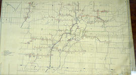
Map of Hastings County in 4 sections
Part of Map collection
A map of Hastings County outlining townships from the Bay of Quinte in the south, to Wallaston, Limerick and Cashel in the north.
Map is in four sections. Scale: 3 miles : 1 inch. Original map is dated 1894. Photocopy from the Archives of Ontario.