Rawdon, Township of

Taxonomy

Code

Scope note(s)

Source note(s)

Display note(s)

Hierarchical terms

Rawdon, Township of

Rawdon, Township of

Equivalent terms

Rawdon, Township of

Associated terms

Rawdon, Township of

65 Archival description results for Rawdon, Township of

65 results directly related Exclude narrower terms

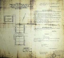
Plan of Park Lots 13-14 in the village of Stirling

A certified reproduction of the "Subdivision of part of Park Lots # 13 & 14 (shown on plan by Emerson, P. L. S.), east of Edward Street in Village of Stirling, being part of Lot # 10, Concession 1, Rawdon. Laid out for Robert Potts Fidlar." Surveyed by Thomas O. Bolger for Evans & Bolger, P. L. S., and signed September 1874.

This copy was made in 1972 of plan #176, as registered in the Hastings Land Registry Office.

Donated by Walter I. Watson, O.L.S.

Evans and Bolger

Plan of the village of Springbrook

A certified reproduction of the "Plan of Village of Springbrook, being Lots # 13 in Concession 9 and 10 in Rawdon Township, certified by James Duncan, Reeve, G. D. Higgins, Clerk.” Plan bounded in the north by the Road between Concession # 10 & 11, in the south by the road between Concession 9 & 10 and in the east by the line between Lots # 12 & 13. Surveyed by C. Fraser Aylsworth Jr., P. L. S., and signed May 9, 1887.

This copy was made in 1972 of plan #259, as registered in the Hastings Land Registry Office.

Donated by Walter I. Watson, P. L. S.

Aylsworth, Charles Fraser Jr., O.L.S.

Plan of Wellington Block in the village of Stirling

A certified reproduction of the "Wellington Block in Village of Stirling in Township of Rawdon...For Robert Potts Fidlar, Belleville merchant.” The block includes the eastern part of Park Lots # 13-14 and Park Lot # 12, east of Edward Street. Surveyed by Thomas O. Bolger, P. L. S. and dated March 9, 1877.

This copy was made in 1972 of plan #206, as registered in the Hastings Land Registry Office.

Donated by Walter I. Watson, P. L. S.

Bolger, Thomas Oliver, P.L.S.

Subdivision of Lots 13-21 in the village of Stirling

A certified reproduction of the "Subdivision of Parts of Lots # 16 to 21, Lot # 13 and North 34 feet of Lot # 14. Haslett Plan of Village of Stirling, Township of Sidney and Rawdon.” The area includes; Lots # 16 to 21 inclusive on the east side of Henry Street and Lots # 13 and north 34 feet of Lot # 4 on the west side of Henry Street. Surveyed by Donevan & Richards, O. L. S. and signed January 27, 1951.

This copy was made in 1972 of plan #859, as registered in the Hastings Land Registry Office.

Donated by Walter I. Watson, P. L. S.

Donevan & Richards, O. L. S.

Subdivision of Park Lots 1-2 in the Township of Rawdon

A certified reproduction of the "Subdivision of Easterly parcel of Park Lot # 1 and part of Easterly parcel of Park Lot # 2 according to Reg'd Plan No. 38, being part of Lot XI, Concession 1, Township Rawdon.” The area includes; Park Lots # 1 and part Lot # 2, both bounded by Marmora Road, Wellington Street and Nancy Street. Surveyed by George H. Richards, O. L. S. and signed December 28, 1951.

This copy was made in 1972 of plan #875, as registered in the Hastings Land Registry Office.

Donated by Walter I. Watson, P. L. S.

Richards, George Henry 'Harry', O.L.S.

Hydro-Electric Power Commission of Ontario, Bonarlaw Section

  • CA ON00156 M/M430-2995 - 2996, 3018 - 3021, 3031/3031
  • Item
  • 24 Feb 1943
  • Part of Map collection

An original map produced for the Hydro-Electric Power Commission of Ontario, concerning hydro power lines, stations and transformers in Bonarlaw, within the Township of Rawdon. However, the map also features railways, roads and land boundaries. Dated February 24, 1943.

This map includes parts of Concession 11 Lot # 13, Concession 12 Lot # 12 and Lot # 14.

Donated by David Pershick.

Hydro-Electric Power Commission of Ontario, Frankford Section

  • CA ON00156 M/M430-2995 - 2996, 3018 - 3021, 3031/3020
  • Item
  • c. 1950
  • Part of Map collection

An original map produced for the Hydro-Electric Power Commission of Ontario, concerning hydro power lines, stations and transformers. However, the map also features railways, roads and land boundaries.

This map is of the North Section - Frankford Rural Power District. The total area includes parts of Thurlow, Huntingdon, Sidney, Rawdon, Campbellford, Seymour, Brighton, and Percy Townships. Circa 1950.
Donated by David Pershik.

Hydro-Electric Power Commission of Ontario, Rawdon Section

  • CA ON00156 M/M430-2995 - 2996, 3018 - 3021, 3031/2995
  • Item
  • 16 Dec 1964
  • Part of Map collection

A reproduction of an original map produced for the Hydro-Electric Power Commission of Ontario, concerning the boundaries of their eastern region in the Township of Rawdon. However, the map also features railways, roads and land boundaries. Dated December 16, 1964. Scale: 2 inches = 1 mile.

Donated by David Pershick.

Rawdon Township Map # 443772W

  • CA ON00156 M/M470-2591 - 2616/2596
  • Item
  • c. 1950
  • Part of Map collection

A reproduction of an air survey photograph produced by the Ontario Ministry of Natural Resources. Map # 443772W of Rawdon Township in Hastings County, Ontario. Circa 1950.

The photograph shows the west part of Rawdon Township and the east part of Huntingdon Township.

Donated by Walter I. Watson, P. L. S.

Ontario. Ministry of Natural Resources and Forestry

Rawdon Township Map # 443773E

  • CA ON00156 M/M470-2591 - 2616/2597
  • Item
  • c. 1950
  • Part of Map collection

A reproduction of an air survey photograph produced by the Ontario Ministry of Natural Resources. Map # 443773E of Rawdon Township in Hastings County, Ontario. Circa 1950.

The photograph shows Glen Ross, Oak Lake, Stirling and north to Concession 7.

Donated by Walter I. Watson, P.L.S.

Ontario. Ministry of Natural Resources and Forestry

Rawdon Township Map # 444773E

  • CA ON00156 M/M470-2591 - 2616/2603
  • Item
  • c. 1950
  • Part of Map collection

A reproduction of an air survey photograph produced by the Ontario Ministry of Natural Resources. Map # 444773E of Rawdon Township in Hastings County, Ontario. Circa 1950.

The photograph shows Rawdon Township from the eastern border to Hwy 14, Harold and Springbrook Villages, western Huntingdon Township, southern Marmora and Madoc Townships, Banker Lake.

Donated by Walter I. Watson, P.L.S.

Ontario. Ministry of Natural Resources and Forestry

Rawdon Township Map # 444773W

  • CA ON00156 M/M470-2591 - 2616/2604
  • Item
  • c. 1950
  • Part of Map collection

A reproduction of an air survey photograph produced by the Ontario Ministry of Natural Resources. Map # 444773W of Rawdon Township in Hastings County, Ontario. Circa 1950.

The photograph shows Rawdon Township, Concession 8 to 14, west of Hwy 14, small sections of Marmora Township including Marmora Village and Crow Lake and a small part of Seymour Township in Northumberland County

Donated by Walter I. Watson, P.L.S.

Ontario. Ministry of Natural Resources and Forestry

Plan of Hastings for Hastings Directory

A map of Hastings County outlining townships:
Marmora, Lake, Madoc, Tudor, Grimsthorpe, Elzevir; Rawdon, Huntingdon, Hungerford, Sidney, Thurlow, Tyendinaga - as well as the northern townships.
Inset is "the Village of Marmora." Surveyed by H. A. F. Macleod, C.E. and P.L.S. Published by W. A. Little Lith., Montreal in the 1864-1865 copy of the Hastings Directory . Scale: 1:190,000.

MacLeod, Henry Augustine Fitzgerald, P.L.S.

Lloyd's Map of Hastings County

A map of Hastings County outlining the twelve townships:
Marmora and Lake, Madoc, Tudor, Grimsthorpe, Elzevir; Rawdon, Huntingdon, Hungerford, Sidney, Thurlow, Tyendinaga. The northern townships are pictured on the right side.
As well as, the lots and concessions. Circa 1922. Scale: 1.5 miles: 1 inch. Published by Lloyd's Maps, Map Publisher.

Lloyd's Map, Map Publisher

Map of Hastings with townships

A map of Hastings County outlining the twelve townships:
Marmora and Lake, Madoc, Tudor, Grimsthorpe, Elzevir; Rawdon, Huntingdon, Hungerford, Sidney, Thurlow, Tyendinaga.
As well as, the lots and concessions. Circa 1916.Scale: 4 miles: 1 inch.

Donated by K.G.M. Ross.

Map of Hastings and Prince Edward Counties

A map showing the roads, forts and inns of Hastings and Prince Edward Counties in 1850, by Major Baron DeRottenburg. The map extends from Brighton to Gananoque, Prince Edward County. and North to include Rawdon, Huntingdon, Hungerford Townships of Hastings County. Scale: 2 miles = 1". Dimensions 63cm x 44cm.

DeRottenburg, Major Baron

Hastings with Town of Belleville and principal villages

A map of Hastings County including the Town of Belleville and other principal villages:

Trenton, Madoc, Marmora, Tweed, Bridgewater, Stirling, Wicklow, Bangor, Herschel, Monteagle, Carl, Dungannon, Wollaston, Limerick, Cashel, Tudor, Grimsthorpe, Elzevir; Rawdon, Huntingdon, Hungerford, Sidney, Thurlow, Tyendinaga.

Scale: 3 miles =1 inch. Published by John P. Evans, P.L.S. in 1869.

Evans, John Dunlop, P.L.S.

Results 21 to 40 of 65