Ontario

Taxonomy

Code

Scope note(s)

Source note(s)

Display note(s)

Equivalent terms

Ontario

Associated terms

Ontario

24 Archival description results for Ontario

Only results directly related

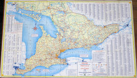
Road Map of the Province of Ontario 1967

A road map of the northern and southern portions of the Province of Ontario. Published by the Ontario Department of Highways in 1967 for the Centennial Year. Various indexes and legends are located on the map.

Ontario. Department of Highways

Road Map of the Province of Ontario 1956

A road map of the northern and southern portions of the Province of Ontario. Published by the Ontario Department of Highways in 1956. Various indexes and legends are located on the map.

Ontario. Department of Highways

Road Map of the Province of Ontario 1953

A road map of the northern and southern portions of the Province of Ontario. Published by the Ontario Department of Highways in 1953. Various indexes and legends are located on the map.

Ontario. Department of Highways

Road Map of the Province of Ontario 1964

A road map of the northern and southern portions of the Province of Ontario. Published by the Ontario Department of Highways in 1964. Various indexes and legends are located on the map.

Ontario. Department of Highways

Road Map of Central Canada 1939

A map of Central Canada detailing various roads, towns and cities. The total area extends from west Sarnia to east Prescott and north Algonquin Park to south Lake Ontario. Map dated 1939. Published by Imperial Oil Limited. Scale: 15 miles to 1 inch.

Imperial Oil Limited

"Things to see and do in Ontario" Map

A map of Ontario detailing sports and activities located within the "Heart of Canada - Ontario - [an] easy to reach vacation land!" The "things to see & do" are located at different stops along the Trans-Canada Highway. Map dated 1961. Published for free distribution by the Department of Travel & Publicity of the Province of Ontario.

Ontario. Department of Travel and Publicity

Road Maps of Ontario

  • CA ON00156 M/M425-1028-1031, 1038 & M400-3042, 3043, 3047
  • Series
  • 1961-2009
  • Part of Map collection

Various road maps of Ontario published by the Canadian Government.

A Map of Canada, 1972

  • CA ON00156 M/M400-3036, 3038 - 3041, 3044/M400-3044
  • Item
  • Mar 1972
  • Part of Map collection

A map of all of Canada, by the National Geographic Society's Cartography Section. Scale: 1;7460,000 or 117.7 miles to the inch. Dated March 1972.

National Geographic Society

A Map of the Atlantic Gateways

  • CA ON00156 M/M400-3036, 3038 - 3041, 3044/M400-3041
  • Item
  • Mar 1983
  • Part of Map collection

A map showing the gateways of the Atlantic Ocean in North America, by the National Geographic Society's Cartography Section. Scale: 1 centimeter = 13.2 kilometers or 1 inch= 20.8 miles. Dated March 1983.

National Geographic Society

A Map of the Great Lakes

  • CA ON00156 M/M400-3036, 3038 - 3041, 3044/M400-3040
  • Item
  • Jul 1987
  • Part of Map collection

A map showing the Great Lakes of Canada and the USA, by the National Geographic Society's Cartography Section. The totally area shown includes west Manitoba to east Quebec and north to Lake Nipigon and south to U. S. A. Scale: 1 centimeter = 23 kilometers or 1 inch = 36 miles. Dated July 1987.

National Geographic Society

A Close Up of Southern Ontario, Ontario, and Canada

  • CA ON00156 M/M400-3036, 3038 - 3041, 3044/M400-3036
  • Item
  • Dec 1978
  • Part of Map collection

A map entitled "A Close Up of Southern Ontario, Ontario, and Canada" by the National Geographic Society's Cartography Section. Scale: 1 centimeter = 30 kilometers or 1 inch = 47.3 miles. Dated December 1978.

National Geographic Society

Results 1 to 20 of 24