Ontario

Taxonomie

Code

Bereik aantekeningen

ron aantekeningen

Toon aantekening(en)

Gelijksoortige termen

Ontario

Verwante termen

Ontario

12 Archivistische beschrijving results for Ontario

Only results directly related

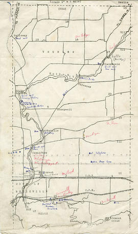
Map of Thurlow Township with annotations

A map of Thurlow Township featuring the addition of handwritten annotations. Concessions, railways, proprietors, businesses and locations are featured. The map extends from the Bay of Quinte in the southwest to Roslin the northeast. Circa 1950 (Bakelite plant opened c. 1948 and the Foxboro Cheese Factory closed in 1961).

Specific annotations are as follows: Halloway Grist Mill, Latta Bridge, Plainfield Grist, Saw Mill, O'Brien's Bridge, Grist Mill, Canning Factory Foxboro, Footbridge, Cheese Factory, Fairfields Bridge, Dam Corbyville, Distillery, Cannifton Dam, Grist & Saw Mill, Quarry & Substation, Round House, Brickyard, Graham's Dried Foods, Bell Telephone Lines, Hydro Power Lines, and Cement Works.

Belleville Transit Bus Route Maps

Each map was published by the Belleville Transit Commission and features street names, transit routes and rider fares.

Zonder titel

Maps of Belleville on the Bay of Quinte

  • CA ON00156 M/M440-1367, 1391-1392, 1826
  • Stuk
  • 2000-2010
  • Part of Map collection

Each map was published by the Ontario Mapping Company and features advertisements, streets, transit routes and points of interest.

1) M440-1367. Dated from 2000-2001. Scale 2.5 cm : 0.5 km. Composed by the Belleville & District Chamber of Commerce.
2) M440-1390. Dated from 2008-2009.
3) M440-1391. Dated from 2006-2007.
4) M440-1392. Dated from 2003-2004.
5) M440-1826. Dated 2010.

Zonder titel

City of Belleville Aerial photographs 1980

  • CA ON00156 M/M440-2811, 2812, 2815-2820
  • Stuk
  • 1978-1980
  • Part of Map collection

Scale 1= 10000.

1) M440-2811. Belleville, Aerial Photo Map # TD29121Z. Photo showing Belleville east city limits to Murray Township Lot # 8, and north from 1st Concession to Hwy 401 Corridor. Dated July 20, 1978.

2) M440-2812. Belleville, Aerial Map # 808/14/1/6. Photo showing City of Belleville, Bay Bridge Road, Dundas West Road, Four Seasons Hotel, Zwicks Park, and Albert College. Dated 1980.

3) M440-2815. Belleville, West, Aerial Photo # 78-4411/16/191. Photo showing Dundas St. West and Belleville & St. James Cemeteries, Marshall Road, West Bridge St. & Highland Ave. Circa 1978-80.

4) M440-2816. Belleville, West (Central), Aerial Photo # 78-4412/16/58. Photo showing Victoria Island, College Street, Drive in Theatre at West Bridge Street and Palmer Road, Village Dr. & Cascade Blvd. Circa 1978-80.

5) M440-2817. Belleville, East, Central- Photo # 78-4412/16/60. Photo showing the Bay of Quinte, Kiwanis Bayshore Park, Victoria Island, College St. and Bridge St. Circa 1978-80.

6) M440-2818. Belleville, North West, Aerial Photo # 78-4413/24/198. Photo showing MacClead Dam on Moira River in South East corner of photo; Hwy 401 at North on photo. Circa 1978-80.

7) M440-2819. Belleville, North East, Aerial Photo # 78-4413/24/200. Photo showing Victoria Ave., Jamieson Bone Road, Yardmen's Arena [Sports & Welliness Centre]. Circa 1978-80.

8) M440-2820. Belleville, East, Aerial photo #78-4412/16/62. Photo showing Bertram Blvd. and Bay of Quinte to Edge Hill Road & Stanley Park. Circa 1978-80.

Zonder titel

Floor plans for L. W. Yeoman's Drug Store

An original hand-painted, paper set of floor plans. The plan was drawn in 1873 for L. W. Yeoman & Company's drug store. The store was located on the corner of Front and Market Streets. The drawings cover the plans for the foundation, ground, second and third floors. Scale: 8 feet to one inch. Published by H. Belden & Company. John Forin built the building.

Zonder titel

Ontario broadsides, 1793-1893

File contains a printed booklet entitled “A Century of Ontario Broadsides, 1793-1893,” by the Toronto Public Library, June, 1965. The booklet provides images and texts of several government and commercial proclamations and announcements in Upper Canada and Ontario.