Map of County of Northumberland with County Seat at Cobourg
- CA ON00156 M/M420-2185
- Unidad documental simple
- 1974
Parte deMap collection
A map of the County of Northumerland with County Seats at Cobourg. Included are the lots and concessions.
318 resultados directamente relacionados Excluir términos relacionados
Map of County of Northumberland with County Seat at Cobourg
Parte deMap collection
A map of the County of Northumerland with County Seats at Cobourg. Included are the lots and concessions.

Hydrographic Map of Bay of Quinte, Picton to Presqu'ile Bay
Parte deMap collection
A hydrographic map of the area surrounding the Bay of Quinte, Picton to Presqu'ile Bay in Ontario, Canada. With maps of Trenton Approaches, [racist slur redacted] Narrows, Belleville Harbour & Telegraph Narrows inset. Surveys completed in in 1952-53 and 1957. Map printed June 15, 1962. Published by the Canadian Hydrographic Service, Marine Sciences Branch, Department of Mines and Technical Surveys, Ottawa. Sheet number 2069.
Sin título
Aerial Photograph of west Prince Edward County
Parte deMap collection
An aerial photograph of Prince Edward County focusing on the area north from Pleasant Bay to south Huyck's Bay.
Aerial Photograph of Prince Edward County
Parte deMap collection
An aerial photograph of Prince Edward County.
Sin título

Regional Plan 411 of Lots in Bancroft
Parte deMap collection
A plan of "Lots 1-2, Concessions A-B, Lots 59-67 west of Hastings Road & Lot 1, Concession 15, Township of Faraday, Regional Plan 411." The lots are located in the town of Bancroft, on either sides of the York River. Original map composed in 1911 by W. J. Moore, O.L.S. This version was traced in 1945.
Sin título

Road Map of Prince Edward County 1955
Parte deMap collection
A road map of Prince Edward County in 1955. Portions of adjoining counties are also pictured. County boundaries are yellow, while roads are blue and red. Published by the Ontario Department of Highways. Scale: 1 inch = 4 miles.
Sin título
Map of Northumberland County 2001
Parte deMap collection
A map of the roads in Northumberland County in 2001, including Hop, Hamilton, Alnwick Haldimand, Cramah, Brighton, Percy, Campbellford and Seymour Townships.
Donated by the Belleville Public Library in 2014.
Sin título

Map of Fredericksburg Township
Parte deMap collection
A survey plan map of the Township of Fredericksburg, 1784. Contains names of local property owners and bodies of water. Composed by James Peachy, Lewis Kotte, Henry Holland and Samuel Jaffe. Scale: 40 chains in an inch. Dimensions: 53cm x 39cm.
Sin título

Parte deMap collection
A map showing concessions and lots of Huntingdon - Madoc Township, Hastings County. Circa 1869. 30 advertisements for companies surround the map. Published by Macleod and Carre, Engineers and Surveyors. Scale: 1:63,000. Dimensions: 34.0cm x 37.0cm. Map was created from Government plan.
Donated from the Col. W. N. Ponton Estate. Penciled notes on map show Ponton family's interest in mining, especially after the Eldorado Gold Rush in 1866.
Sin título

Parte deMap collection
Map showing concessions, traveled roads and lots of Marmora Township, Hastings County. Areas of gold mines are also charted. Scale: 1 mile : 1 inch. Published by MacLeod & Carre Engineers and Surveyors in Belleville, Ontario (Canada West). Local advertisements surround map.
Received from the Public Archives of Canada on 3 May 1971.
Sin título
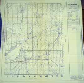
Map of Marmora Township in Hastings County
Parte deMap collection
A map of Marmora Township in Hastings County showcasing the mining industry in Eastern Ontario. Concessions and lots are numbered. Plan number E. O. 67 from the Ontario Department of Mines, issued on October 1, 1953. Scale: 1:30,000.
Sin título

Parte deMap collection
A map of Sidney Township, specifically the District of Mecklenburg in 1787. Contains information on the plans for the 1st, 2nd, and 3rd concessions, as well as property owners. Created by Lewis Kotte, Deputy Provincial Surveyor. Scale: 40 chains to an inch.
Sin título

Parte deMap collection
Map showing a sketch of the Trent Port - June 12th, 1837. Scale: 2 chains to an inch. Published by the Office of the Surveyor General.
From the Archives of Ontario in Toronto.

Parte deMap collection
Map showing lots in Sidney Township, 1878. Scale: about 50 chains to an inch.

Parte deMap collection
A map of Sidney Township, the Plan of Lots on Gladstone Avenue/Trent Road, 1912. Published by Lucien & Allen C.E. on January 2nd, 1912. Created by A.W. Ponton, P.L.S. Scale: 100 feet : 1 inch.
Sin título
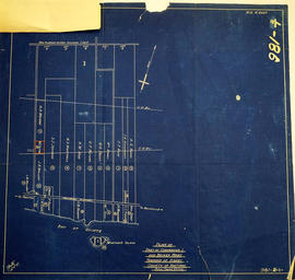
Map of Expropriated Land for Trenton Air Base
Parte deMap collection
A map of Sidney Township, part of Concession #1 and Broken Front, October 18th, 1912. The map details a tract of land expropriated for Trenton Air Base. Scale: 12.5 chains : 1 inch.
Attached is a letter dated May 1st, 1931, The King versus Maitland Hutton and Leda Hutton.

Lot Division Map of Sidney Township
Parte deMap collection
A lot division map of Sidney Township in Hastings County, Ontario. Published by the Department of Land Surveys on August 18th, 1944. Scale: 1=4,000.
Bottom right corner reads "Dominion of Canada, War Assets Corporation" and discusses a storage yard location on Lot 3, Concession 1.
Sin título
Sidney Township Zoning Bylaw Concessions 1&2
Parte deMap collection
"Township of Sidney Zoning Bylaw" in concession, B. F. 1 & 2. Dated 2 Feb 1978. Published by the Quinte Planning Board. Composed by M. A. B.
Sin título
Sidney Township Zoning Bylaw Concessions 3-5 to 401
Parte deMap collection
"Township of Sidney Zoning Bylaw" in concessions 3-5 to Highway 401. Dated 2 Feb 1978. Published by the Quinte Planning Board. Composed by Laura.
Sin título
Sidney Township Zoning Bylaw Concessions 6-9
Parte deMap collection
"Township of Sidney Zoning Bylaw" in concessions 6-9. Dated 2 Feb 1978. Published by the Quinte Planning Board. Composed by Laura.
Sin título