Ontario

Taxonomie

Code

Bereik aantekeningen

ron aantekeningen

Toon aantekening(en)

Gelijksoortige termen

Ontario

Verwante termen

Ontario

5979 Archivistische beschrijving results for Ontario

402 results directly related Exclude narrower terms

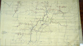
Hydro-Electric Power Commission of Ontario, Tweed Section

  • CA ON00156 M/M430-2995 - 2996, 3018 - 3021, 3031/3021
  • Stuk
  • 16 Oct 1951
  • Part of Map collection

An original map produced for the Hydro-Electric Power Commission of Ontario, concerning hydro power lines, stations and transformers. However, the map also features railways, roads and land boundaries.

This map is of the Southwest Section - Tweed Rural Power District. The total area includes parts of Hungerford, Huntingdon, and Thurlow Townships. Dated October 16, 1951. Scale: 2 inches = 1 mile.

Donated by David Pershik.

Seymour Power & Electric Co. Limited in Murray Township

  • CA ON00156 M/M430-2998 - 3001/M430-3000
  • Stuk
  • c.1910
  • Part of Map collection

An original map produced for the Seymour Power & Electric Co. Limited, concerning proposed transmission lines within the Township of Murray. However, the map also features railways, roads, mills and land boundaries. Circa 1910. Scale: 50 chains = 1 inch. Map composed by Smith, Kerry and Chace Engineers located in Toronto, Winnipeg, Calgary and Vancouver.

Donated by David Pershick.

Zonder titel

Trenton Electric & Water Co. Limited in Sidney Township

  • CA ON00156 M/M430-2998 - 3001/M430-3001
  • Stuk
  • c. 1910
  • Part of Map collection

An original map produced for the Trenton Electric & Water Co. Limited, concerning proposed transmission lines within the Township of Sidney. However, the map also features railways, roads and land boundaries. Circa 1910. Scale: 50 chains = 1 inch. Map composed by Smith, Kerry and Chace Engineers located in Toronto, Winnipeg, Calgary and Vancouver.

Donated by David Pershick.

Zonder titel

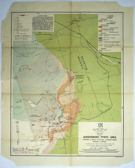
Map of the Queensboro Pyrite Area

An original map of the Queensboro area, indicating specific geological areas and signs. Includes the Townships of Madoc and Elzevir in the County of Hastings, Ontario. Dated 1913. Published by the Ontario Department of Lands, Forests and Mines. Scale: 800 feet to an inch.

Donated by David Pershik.

Zonder titel

A Close Up of Southern Ontario, Ontario, and Canada

  • CA ON00156 M/M400-3036, 3038 - 3041, 3044/M400-3036
  • Stuk
  • Dec 1978
  • Part of Map collection

A map entitled "A Close Up of Southern Ontario, Ontario, and Canada" by the National Geographic Society's Cartography Section. Scale: 1 centimeter = 30 kilometers or 1 inch = 47.3 miles. Dated December 1978.

Zonder titel

Ontario Map from the National Topographic Series

A topographical map of Ontario from the Department of Mines and Technical Surveys, Surveys and Mapping Branch. Area includes west Lake Superior, east Quebec, north James Bay and south to Lake Erie. Dated April 30, 1956. Scale 1:63,360.

Zonder titel

Canada Map Index 1 from the National Topographic System

A topographical map of Ontario from the Canada Index 1, Maps of the National Topographic System of Canada. Published by the Department of Mines and Resources (now the Department of Natural Resources). Dated July 1991. Scale 1:50,000.

Zonder titel

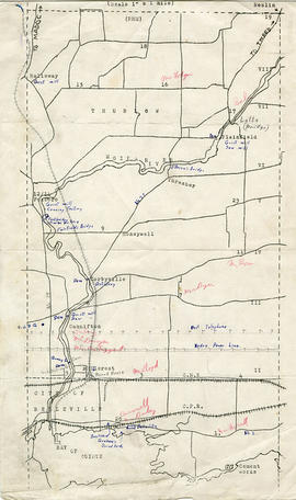
Map of Thurlow Township with annotations

A map of Thurlow Township featuring the addition of handwritten annotations. Concessions, railways, proprietors, businesses and locations are featured. The map extends from the Bay of Quinte in the southwest to Roslin the northeast. Circa 1950 (Bakelite plant opened c. 1948 and the Foxboro Cheese Factory closed in 1961).

Specific annotations are as follows: Halloway Grist Mill, Latta Bridge, Plainfield Grist, Saw Mill, O'Brien's Bridge, Grist Mill, Canning Factory Foxboro, Footbridge, Cheese Factory, Fairfields Bridge, Dam Corbyville, Distillery, Cannifton Dam, Grist & Saw Mill, Quarry & Substation, Round House, Brickyard, Graham's Dried Foods, Bell Telephone Lines, Hydro Power Lines, and Cement Works.

Map 3 from the Hydro Comission Route Inquiry

A map studying the proposed routes for power transmission from Lennox to Oshawa. The area covers from West Oshawa, East Mount Pleasant Jct. North Rice Lake & South Lake Ontario.

Zonder titel

Plan of Survey of the Village of Stirling

A plan of survey of part of Blocks D & E, north of Church Street. Registered Plan 149 & Lots 1,2 & 3 Part of Lot # 4, south of Albert Street.

Zonder titel

Canadian National Railway System Map

"The Only Railway Serving All Ten Provinces of Canada:" a map showing the Canadian National Railway System in 1952. The map includes: Canadian National Railways, Grand Trunk Western Railroad Company, Central Vermont Railway Inc., Duluth, Winnipeg and Pacific Railway Company. Composed by C.N.R. Montreal. Scale 10/16 of an inch to 50 miles.

Donated by Bruce Polmanter.

Zonder titel

Belleville newspaper building reports

  • Stuk
  • 2014

File contains transcripts of newspaper reports on new buildings in Belleville, Ontario. The reports date from 1856 to 1914.

Zonder titel

Belleville's Heritage volumes

  • Reeks
  • 1978, 1983

These volumes were compiled by the Historic Structures Committee of the Hastings County Historical Society in 1978 and 1983. They contain photographs and descriptions of some of the older buildings in Belleville, Ontario.

Zonder titel

Resultaten 121 tot 140 van 5979