Ontario

Taxonomy

Code

Scope note(s)

Source note(s)

Display note(s)

Equivalent terms

Ontario

Associated terms

Ontario

640 Archival description results for Ontario

138 results directly related Exclude narrower terms

Plan of Easements Lot 1-86 in Trenton

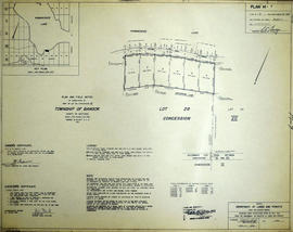
A certified reproduction of the "Compiled Plan of Easements, Part of Lots # 1 to 86 & part of Blocks B & C. Reg. Plan No. 1946, Town of Trenton.” The area includes; East of Byron Street & including Connolly Avenue, Shoniker Avenue, Nelles Avenue. Surveyed by Edward C. Carter, O. L. S. (Carter Horwood Ltd. , O. L. S.) and signed August 13, 1971.

Donated by Walter I. Watson, P. L. S.

Carter, Edward Christian, O.L.S.

Registrar's Plan of Lots 28-30 in the Township of Lake

A certified reproduction of the "Registrar's Compiled Plan, being a graphic index of part of Lots # 28, 29, 30, Concession 10, Township of Lake.” The area includes; Lots # 1 to 74 on the East shore of Dickey Lake and around the point of shore line to road allowance between Concession 10 and 11, Township of Lake. Surveyed by John G. Pierce, O. L. S. and signed April 18, 1969.

Donated by Walter I. Watson, P. L. S.

Pierce, John Gourlay, O.L.S.

Registrar's Plan of Lots 30-31 in the Township of Lake

A certified reproduction of the "Registrar's Compiled Plan, being a graphic index of part of Lots # 30 & 31.” The area includes;Lots # 75 to 130 on the East and Northerly shores of Dickey Lake. Surveyed by John G. Pierce, O. L. S. and signed April 18, 1969.

Donated by Walter I. Watson, P. L. S.

Pierce, John Gourlay, O.L.S.

Subdivision of all of Block A in the Town of Trenton

A certified reproduction of the "Subdivision of All of Block “A”, Reg. Plan No. 1946, Trenton, owner Stanley Heights (Trenton) Ltd.” The area includes; Lots # 1 to 11 East of Byron Street to Shoniker Avenue and South of Connolly Avenue in Town of Trenton. Surveyed by W. J. Pattison, O. L. S. and signed October 4, 1973.

Donated by Walter I. Watson, P. L. S.

Pattison, William James, O.L.S.

Subdivision of all of Park Lot 48 in the Town of Trenton

A certified reproduction of the "Subdivision of All of Park Lot # 48 and North half of Park Lot # 39 West of Byron Street. Reg. Plan No. 64, Trenton.” The area includes; Lots # 1 to 24, Block “A” & Block “B” on Hollandale Ave., being West of Byron Street and Southerly of Kidd Ave. Surveyed by W. J. Pattison, O. L. S. and signed July 28, 1973.

Donated by Walter I. Watson, P. L. S.

Pattison, William James, O.L.S.

Subdivision of Park Lot 19 in the Town of Trenton

A certified reproduction of the "Subdivision of Part of Park Lot # 19, Reg. Plan 232, Trenton.” The area includes; Lots # 1 to 16, Blocks “A” and “B”, Streets, Adrian Courtand, Charlotte St. being West of Sidney Street and Northerly of Edward Street. Surveyed by J. Vinkler, O. L. S. and signed August 21, 1973.

Donated by Walter I. Watson, P. L. S.

Vinklers, John, O.L.S.

Subdivision of Part of Lot #26 in the Township of Cashel

A certified reproduction of the "Subdivision of Part of Lot # 26, Concession V & VI, Township of Cashel, surveyed for Dept. of Lands & Forests.” The area includes; Lots # 1 to 13 on the West shore of Cashel Lake. Surveyed by N. H. Verhoef, O. L. S., Pierce & Pierce, O. L. S. and signed November 27, 1967. Scale: 1 inch = 100 ft.

Donated by Walter I. Watson, P. L. S.

Verhoef, N.H., O.L.S.

Subdivision of Part of Lots #28-29 in the Township of Cashel

A certified reproduction of the "Subdivision of part of Lots # 28 & 29, Concession VIll, Township of Cashel, surveyed for Dept. of Lands & Forests.” The area includes; Lots # 1 to 15 and Block “A” on the southeast shore of Lake Mephisto, being Lots # 28 & 29, Concession 8, Township of Cashel. Surveyed by N. H. Verhoef, O. L. S. of Pierce & Pierce, O. L. S. and signed November 29, 1967. Scale: 1 inch = 100 ft.

Donated by Walter I. Watson, P. L. S.

Verhoef, N.H., O.L.S.

Subdivision of Part of Lot #30 in the Township of Cashel

A certified reproduction of the "Subdivision of part of Lot #30, Concession VIll, Township of Cashel, surveyed for Dept. of Lands & Forests.” The area includes; Lots # 1 & 2 on the east shore of Lake Mephisto with the west side line between Lots # 30 & 31, Concession VIII, Township of Cashel. Surveyed by Michael Joseph McAlpine, O. L. S. and signed August 27, 1968. Scale: 1 inch = 100 ft.

Donated by Walter I. Watson, P. L. S.

McAlpine, Michael Joseph, O.L.S.

Subdivision of Part of Lots #16-17 in the Township of Mayo

A certified reproduction of the "Subdivision of part of Lots # 16 and 17, Concession V, Township of Mayo, surveyed for Dept. Lands & Forests.” The area includes; Lots # 1 to 4 on the northeast shore of [Little] Mayo Lake, being on part of Lot # 16 & 17, Concession V, Township of Mayo. Surveyed by Michael Joseph McAlpine, O. L. S. and signed August 1, 1967. Scale: 1 inch = 50 ft.

Donated by Walter I. Watson, P. L. S.

McAlpine, Michael Joseph, O.L.S.

Subdivision of Part of Lots #27-28 in the Township of Bangor

A certified reproduction of the "Subdivision of part of Lots # 27 & 28, Concession XII, Township of Bangor surveyed for Dept. of Lands & Forests.” The area includes; Kamaniskeg Lake- Lots # 1 to 14 on the West and Northerly shore. Surveyed by Grange W. Elliott, O. L. S. and signed May 22, 1968. Scale: 1 inch = 100 ft.

Donated by Walter I. Watson, P. L. S.

Elliott, Grange W., O.L.S.

Subdivision of Part of Lot 28 in the Township of Bangor

A certified reproduction of the "Subdivision of part of Lot # 28, concession VII, Township of Bangor, surveyed for Dept. of Lands & Forests.” The area includes; Kamaniskeg Lake: Lots # 1 to 6 along the south shore on Lot # 28. Surveyed by Grange W. Elliott, O. L. S. and signed May 22, 1968. Scale: 1 inch = 100 ft.

Donated by Walter I. Watson, P. L. S.

Elliott, Grange W., O.L.S.

Subdivision of Part of Lot 21 in the Township of Bangor

A certified reproduction of the "Subdivision of part of Lot # 21, Concession XII, Township of Bangor, surveyed for Dept of Lands & Forests.” The area includes; Lots # 1 to 11 on the southwest shore of the Madawaska river being Lot # 21, Concession XII, Township of Bangor. Surveyed by Grange W. Elliott, O. L. S. and signed May 29, 1968.

Donated by Walter I. Watson, P. L. S.

Elliott, Grange W., O.L.S.

Subdivision of Part of Lot 28 in the Township of Bangor

A certified reproduction of the "Subdivision of part of Lot # 28, Concession XII, Township of Bangor, surveyed for Dept. of Lands & Forests.” The area includes; Lots # 1 to 14 and Blocks “A” and “B” on the west shore of Kamaniskeg Lake being part of Lot # 28, Concession XII, Township of Bangor. Surveyed by Grange W. Elliott, O. L. S. and signed February 7, 1969.

Donated by Walter I. Watson, P. L. S.

Elliott, Grange W., O.L.S.

Subdivision of Part of Lots 28-29 in the Township of Bangor

A certified reproduction of the "Subdivision of parts of Lots # 28 & 29, Concession XII, Township Bangor, surveyed for Dept. of Lands & Forests.” The area includes; Kamaniskeg Lake Lots # 15 to 30 and Blocks A-B. Block A is designated as public Hwy. The lots are along the west shore starting at the Road allowance between Concession XII and XIII.. Surveyed by Grange W. Elliott, O. L. S. and signed March 3, 1969.

Donated by Walter I. Watson, P. L. S.

Elliott, Grange W., O.L.S.

Subdivision of Part of Lots 28-29 in the Township of Bangor

A certified reproduction of the "Subdivision of parts of Lots # 28 & 29, Concession XIlI, Township of Bangor, surveyed for Dept. of Lands & Forests.” The area includes; Kamaniskeg Lake Lots # 15 to 30 and Blocks A-B. Block A is designated as public Hwy. The lots are along the west shore starting at the Road allowance between Concession XII and XIII. Surveyed by Grange W. Elliott, O. L. S. and signed March 3, 1969.

Donated by Walter I. Watson, P. L. S.

Elliott, Grange W., O.L.S.

Subdivision of Part of Lots 28-30 in the Township of Bangor

A certified reproduction of the "Subdivision of parts of Lots # 28, 29, 30, Concession XIV, Township of Bangor, surveyed for Dept. Lands and Forests.” The area includes; Lots # 48 to 62 in Blocks A & B on the west shore of the Kamaniskeg Lake. Surveyed by Grange W. Elliott, O. L. S. and signed March 3, 1969.

Donated by Walter I. Watson, P. L. S.

Elliott, Grange W., O.L.S.

Subdivision of Part of Lots 29-30 in the Township of Bangor

A certified reproduction of the "Subdivision of part of Lots # 29 & 30, Concession XIV, Township of Bangor, Surveyed for Dept. Lands and Forests.” The area includes; Lots # 71 to 81, Blocks A, B, C on the west shore of Kamaniskeg Lake. Surveyed by Grange W. Elliott, O. L. S. and signed March 3, 1969.

Donated by Walter I. Watson, P. L. S.

Elliott, Grange W., O.L.S.

Subdivision of Part of Lot 22 in the Township of Bangor

A certified reproduction of the "Subdivision of part of Lot # 22, Concession XII, Township of Bangor, surveyed for Dept. of Lands & Forests.” The area includes; Lots # 1 to 18 on east shore of the Madawaska River, from line between Concession 12 & 13, and line between Lots # 22 & 23. Surveyed by Grange W. Elliott, O. L. S. and signed March 3, 1969.

Donated by Walter I. Watson, P. L. S.

Elliott, Grange W., O.L.S.

Subdivision of Part of Lot 22 in the Township of Bangor

A certified reproduction of the "Subdivision of part of Lot # 22, Concession XIlI, Township of Bangor, surveyed for Dept. of Lands & Forests.” The area includes; Lots # 19 to 32 on east shore of the Madawaska River, north from line between Concession XII and Concession XIII, along the east shore of the river. Surveyed by Grange W. Elliott, O. L. S. and signed March 3, 1969.

Donated by Walter I. Watson, P. L. S.

Elliott, Grange W., O.L.S.

Results 101 to 120 of 640