
- CA ON00156 M/M430-1166
- Unidad documental simple
- 1878
Parte deMap collection
Map showing lots in Sidney Township, 1878. Scale: about 50 chains to an inch.
Parte deMap collection
Map showing lots in Sidney Township, 1878. Scale: about 50 chains to an inch.
Map of Thurlow Township 1787 (reproduction)
Parte deMap collection
Map showing Thurlow Township in 1787. Photocopy received from the Archives of Canada July 16, 1978.

Parte deMap collection
Map showing Thurlow Township in 1878. Lots and concessions are show in relation to boundary duration of Crown grants (see insets). Also inset, "Williamsville - Ferry Point and Plainfield." Published by H. Belden & Co. Scale: 50 chains :1 inch.
Photocopy received from the Archives of Canada 26 Jan 1970.
Sin título
Plan to amend east half of Lot # 17 in the Township of Thurlow
Parte deMap collection
A certified reproduction of the "Plan to amend Reg. Plan - being part of east half of Lot # 17, Concession 1 Township of Thurlow (Dept. of Veteran's Affairs).” The area includes; Thurlow Township- east half of Lot # 17, Concession 1, being 33 Lots north of the C. P. Railway line. Surveyed by W.J. Pattison, O. L. S. and signed March 24, 1954.
Donated by Walter I. Watson, P. L. S.
Sin título
Plan to amend part of Lot # 13 in the Township of Sidney
Parte deMap collection
A certified reproduction of the "Plan to amend subdivision Plan No. 988 of part of Lot # 13, Concession 1, Sidney Township.” The area includes; part Lot # 13, Concession 1, east of Road Allowance between Lots # 12 & 13 (White's Road), being 22 Lots on both sides of Quinte Street. Surveyed by W.J. Pattison, O. L. S. and signed February 17, 1956.
Donated by Walter I. Watson, P. L. S.
Sin título
Plan to showing resurvey of part of the Township of Lake
Parte deMap collection
A certified reproduction of the "Plan showing resurvey of part of the Township of Lake.” The area includes; Mudturtle Lake, Crow River, Whetstone Lake, Trout Bay, Tangamong Lake (all on the west side of Lake Township). Surveyed by Pierce & Pierce, O. L. S. and signed August 24, 1956.
Donated by Walter I. Watson, P. L. S.
Sin título
Subdivision of part of east half of Lot 20 in the Township of Sidney
Parte deMap collection
A certified reproduction of the "Subdivision of part of East half of Lot # 20, Broken Front Concession, Township of Sidney.” The area includes; north from Hwy 2 on east half of Lot # 20, Broken Front Concession, Sidney Township, being 15 Lots on the west side of Burns Avenue. Surveyed by M.J. Pattison, O. L. S. and signed April 14, 1956.
Donated by Walter I. Watson, P. L. S.
Sin título

Subdivision of part of Lot 12 in the Township of Thurlow
Parte deMap collection
A certified reproduction of the "Subdivision of part Lot # 12, Concession 1, Township of Thurlow.” The area includes; west part of Lot #12, between Hwy 2 and Bridge Street East, and east of Public School property and Munro Avenue, being Lots on Elizabeth Crescent, Bradgate Road and Bridge Street East. Surveyed by John T. Ransom, O. L. S. and signed July 12, 1956.
Donated by Walter I. Watson, P. L. S.
Sin título

Subdivision of part of Lot 11 in the Township of McClure
Parte deMap collection
A certified reproduction of the "Subdivision of Part of Lot # 11, Concession 12, Township of McClure, Hastings County. Department of Lands & Forests, owner.” The area includes; Boulter Lake, northeast shore, Lots # 1A, 2A, 3A, and 1 to 4 inclusive. Surveyed by M. J. McAlpine, O. L. S. and signed February 11, 1955.
Donated by Walter I. Watson, P. L. S.
Sin título

Subdivision of Lots 12-13 in the Township of Huntingdon
Parte deMap collection
A certified reproduction of the "Subdivision of part Lots # 12 & 13, Concession XIII, Township of Huntingdon.” The area includes; north shore of Moira Lake, and east of County Road No. 1. Surveyed by John Thomas Ransom, O. L. S. and signed March 13, 1957.
Donated by Walter I. Watson, P. L. S.
Sin título
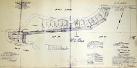
Subdivision of Lots 22-23 in the Township of Tudor
Parte deMap collection
A certified reproduction of the "Subdivision of part Lots # 22 & 23, Concession XIX, Township of Tudor, for Herbert Moore.” The area includes; shore property between Bass Lake and Moore's Road being Lots # 30 to 46, inclusive, beginning at Concession Road between Townships of Tudor & Limerick. Surveyed by John Thomas Ransom, O. L. S. and signed August 9, 1957.
Donated by Walter I. Watson, P. L. S.
Sin título
Subdivision of part of Lot 16 in the Township of Hungerford
Parte deMap collection
A certified reproduction of the "Subdivision of part of Lot # 16, Concession 10, Township of Hungerford. Property owned by Charles Rush.” The area includes; northeast of Stoco Lake on property along Charles Street, by owner of Lot # 16, Concession 10, Hungerford, 29 Lots. Surveyed by W.J. Pattison, O. L. S. and signed July 22, 1957.
Donated by Walter I. Watson, P. L. S.
Sin título
Subdivision of part of Park Lot 7 in the Town of Trenton
Parte deMap collection
A certified reproduction of the "Subdivision of part of Park Lot # 7, West of Sidney St. Evans & Bolger Plan, Town of Trenton, Owner Mr. J. Gould.” The area includes; west of Sidney St. Trenton and Northerly from Dixon Road being 22 Lots on Gould Street, (including Block A). Surveyed by W.J. Pattison, O. L. S. and signed April 24, 1958.
Donated by Walter I. Watson, P. L. S.
Sin título
Subdivision of part of Lot 15 in the Township of Sidney
Parte deMap collection
A certified reproduction of the "Subdivision of part of Lot # 15, Broken Front Concession Township of Sidney, Plan prepared for Mr. Raymond Ghent.” The area includes; east half of Lot # 15, Broken Front, south of Hwy 2, east of Whites Road and west of Aikins Road. Surveyed by W. J. Pattison, O. L. S. and signed March 28, 1958.
Donated by Walter I. Watson, P. L. S.
Sin título

Subdivision of parts of Lot 4 in the Township of Wicklow
Parte deMap collection
A certified reproduction of the "Subdivision of parts of Lot # 4, Concession XI, & Lot # 4, Concession XII, Township of Wicklow. Owner Dept. of Lands & Forests.” The area includes; subdivision on the shore on the west side at north end of Papineau Lake and Papineau Lake Road. Surveyed by M. J. McAlpine, O. L. S. and signed December 12, 1957.
Donated by Walter I. Watson, P. L. S.
Sin título

Subdivision of part of Lot 161 in the Township of Faraday
Parte deMap collection
A certified reproduction of the "Subdivision of Part of Lot # 161, Reg'd Plan No. 41 and part of Lots # 57, 58, 59 & 60. West Hastings Road, township of Faraday now in Village of Bancroft, Prepared for Faraday Uranium Mines Ltd., Bancroft Curling Club, Ltd.” The area includes; Lots # 1 to 100 inclusive, Blocks A, C-D and laid out on streets NewKirk Boulevard, Johnston Crescent, McKee Drive, Williams Drive, Billa Street, and Shore Road. Surveyed by M. J. McAlpine, O. L. S. and signed July 11, 1958.
Donated by Walter I. Watson, P. L. S.
Sin título

Subdivision of part of Lots 24-25 in the Township of Bangor
Parte deMap collection
A certified reproduction of the "Subdivision of part of Lots # 24, Concession IX & X and part of Lot # 25, Concession IX, Township of Bangor.” The area includes; west shore of Kaminiskeg, Lots # 1 to 14, Lots # 1A to 7A, Lots 1 B, 2B, 5B, and Kaminiskeg Lake Road. Surveyed by M. J. McAlpine, O. L. S. and signed May 29, 1958.
Donated by Walter I. Watson, P. L. S.
Sin título

Subdivision of parts of Lot 3 in the Township of Wicklow
Parte deMap collection
A certified reproduction of the "Subdivision of parts of Lot # 3, Concession XII & Lot # 4, Concession XII, Township of Wicklow.” The area includes; Lots # 1, 2, 3 & 3A at the north end of Papineau Lake with “Summer Resort Location” beside Lot # 1. Surveyed by M. J. McAlpine, O. L. S. and signed December 31, 1957.
Donated by Walter I. Watson, P. L. S.
Sin título

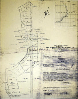
Subdivision of part of Broken Lots 23-24 in the Township of McClure
Parte deMap collection
A certified reproduction of the "Subdivision of part of Broken Lots # 23 & 24, Concession VI and part of Broken Lot # 23, Concession VII, Township of McClure, owner Dept. Lands & Forests.” The area includes; Lots # 1 to 14, 1A to 4A, 8A to 10A. Blocks A-D and Mink Lake Road, being on the west shore of north Mink Lake. Surveyed by M. J. McAlpine, O. L. S. and signed November 24, 1958.
Donated by Walter I. Watson, P. L. S.
Sin título
Subdivision of part of Broken Lots 25-26 in the Township of McClure
Parte deMap collection
A certified reproduction of the "Subdivision of part of Broken Lots # 25 & 26, Concession V & VI, Township of McClure, prepared for Dept. Lands & Forests.” The area includes; Lots # 1 to 11, Lots # 6A, 6B, 7A, 8A, 9A and Blocks A-D, on the east side of south Mink Lake. Surveyed by M. J. McAlpine, O. L. S. and signed November 24, 1958.
Donated by Walter I. Watson, P. L. S.
Sin título