
Survey of the First Loyalists Settlement
- CA ON00156 M/M400-2988
- Item
- c. 1800
Part of Map collection
A reproduction of a survey of one the first Loyalists Settlement in Upper Canada.
Part of the Mika collection (HCM05682).
Survey of the First Loyalists Settlement
Part of Map collection
A reproduction of a survey of one the first Loyalists Settlement in Upper Canada.
Part of the Mika collection (HCM05682).

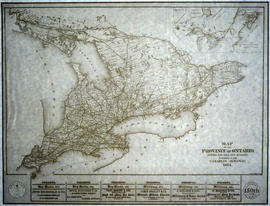
Reproduction of a plan of the organized part of the Provinces of Upper Canada
Part of Map collection
Reproduction of: "A plan of the organized part of the Provinces of Upper Canada according to a Bill which has passed the two Houses, & reserved for the signification of the Royal Pleasure." Surveyed by J. R. Grant Surveyor General. Circa 1798-1802.
Part of the Mika collection.
Ontario Provincial Electoral Districts for the 30th Parliament
Part of Map collection
A map of the Ontario Provincial Electoral Districts during the 30th Parliament. Published by the External Policy Implementation Committee of Ontario Secondary School Teachers Federation.

Map of the Province of Ontario
Part of Map collection
An original "Map of the Province of Ontario showing counties, townships, railways and post offices." Published by COPP Clark Ltd. in 1898.
Copp Clark Limited

Map of the Counties of Hastings and Prince Edward
Part of Map collection
A "Map of the Counties of Hastings and Prince Edward." In 1898, the lots, concessions, churches, schools and mines are shown of the townships in Hastings and Prince Edward. Scale: 1.5 miles to an inch. Published by the Canadian Map Publishing Company in Hamilton, Ontario, for the Belleville Sun. Revised by Henry Carre, C.E. Inset is the map of North Hastings, scale 400 chains to an inch.
Carre, Henry, O.L.S.

Map of the Province of Ontario in counties and districts
Part of Map collection
A "Map of the Province of Ontario in counties and districts" published by the Ontario Department of Municipal Affairs in 1963.
Part of the Van Blaricom collection. The areas where the Van Blaricom family was active is shaded in red ink,
Ontario. Department of Municipal Affairs
Road Map of the Province of Ontario 1964
Part of Map collection
A road map of the northern and southern portions of the Province of Ontario. Published by the Ontario Department of Highways in 1964. Various indexes and legends are located on the map.
Ontario. Department of Highways
Enlargement of the Official Road Map of Ontario 1984-1985
Part of Map collection
An Enlargement of the Official Road Map of Ontario (1984-1985). Includes cities, towns, villages, unincorporated settlements from Lake Erie to Sudbury; Metropolitan Toronto; St. John Ambulance First Aid Post; Nursing Station; Hospital; Indian Reserve. Scale: 1:391,608 Echelle.
Ontario. Ministry of Transportation

Reforestation Land and Existing Woodland in the Moira Watershed
Part of Map collection
3 parts of a map entitled "Source Areas [of] Reforestation Land and Existing Woodland" in the Moira Watershed. The varieties of land use include existing woodland, scrub areas, source areas, crown land, and timber licences. Published by the Ontario Department of Planning Development, Conservation Branch in 1950.
Ontario. Department of Planning and Development

Land Use Survey of the Moira Watershed
Part of Map collection
"Moira Watershed Land Use Survey [for] Recommended Land Use." The varieties of land use include unrestricted, conservation farming, restricted use, permanent vegetation and woodland. Published by the Ontario Department of Planning Development, Conservation Branch in 1950.
Ontario. Department of Planning and Development
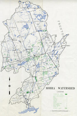
Part of Map collection
A map of the Moira Watershed showing conservation areas, authority forests and the location of large bodies of water.

Electoral Map of the Province of Ontario
Part of Map collection
An Electoral Map of the Province of Ontario, including all of the electoral districts outlined in red. Composed by Surveyor General F. W. Beatty. Published by the Ontario Department of Lands & Forests in 1955. Scale 8 miles to an inch.
Donated by the Argue family in 2013.
Ontario. Department of Lands and Forests
Ontario Map of the National Topographic System
Part of Map collection
Ontario Map of the National Topographic System. Produced by the Centre for Topographic Information, Natural Resources Canada.
Canada. Department of Natural Resources
Research Project of Ontario and its Subdivisions 1788-1867
Part of Map collection
A research project entitled "Ontario and its Subdivisions 1788-1867" by J. L. Morris of the Department of Lands & Forests. 9 maps of Ontario (and parts of Quebec) show the evolution of settlements. The maps are reproductions of originals held at the National Archives of Canada.
Written on the inside cover is "This display for Genealogical reference was mounted and displayed by C. Gordon Crouse of Shawville, Quebec, especially for the O.G.S. Seminar, Guelph, 1968..."
Morris, James Lewis
Large-scale Road Map of Eastern Ontario
Part of Map collection
A large-scale road map of Eastern Ontario. Includes eastern Lake Ontario, St. Lawrence River and Ottawa Valleys. Published by Map Art Publishing Corporation.
Map of Eastern Ontario Trails Alliance with Data
Part of Map collection
A Map of the Eastern Ontario Trails Alliance - recreational trails located in eastern Ontario. Composed by members of the Ontario Geospatial Data Exchange.
Eastern Ontario Trails Alliance

Map of the Province of Ontario for Almanac
Part of Map collection
A "Map of the Province of Ontario, with the recent government surveys, shewing free grant districts, and railways projected & in course of construction." Published by COPP, Clark and Co. for the Canadian Almanac of 1871.
Part of the Mika collection.
Copp Clark Limited

Map of the Dominion of Canada for Almanac
Part of Map collection
A map of the Dominion of Canada, engraved expressly for the Canadian Almanac of 1868. Published by W. C. Chewett and Company. The map includes Ontario, Quebec, New Brunswick, Nova Scotia, Prince Edward Island and Newfoundland - and the districts contained within each province.
Part of the Mika collection.
W. C. Chewett and Co.

New Railway Map of the Province of Ontario
Part of Map collection
A New Railway Map of the Province of Ontario published in the Canadian Almanac of 1888 by Copp Clark Limited.
Copp Clark Limited
Copy of a Map of the Province of Ontario showing Railways
Part of Map collection
A reproduction of a "Map of the Province of Ontario Showing Railways now Running." A series of Toronto business advertisements line the bottom of the map. Originally published by the Canadian Almanac in 1884. Reproduced by COPP Clark Professional in January 1997 for the celebration of 150 continuous years of almanac and directory publishing.
Donated by the Belleville Public Library in 2014.
Copp Clark Limited