Ontario

Taxonomy

Code

Scope note(s)

Source note(s)

Display note(s)

Equivalent terms

Ontario

Associated terms

Ontario

640 Archival description results for Ontario

138 results directly related Exclude narrower terms

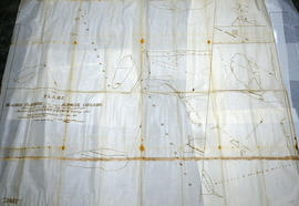
Huyck Islands claimed by Alnwick Indians

An original, waxed linen map entitled "Islands claimed by Alnwick Indians, Pursuant to Instructions bearing date Crown Lands, Dept. Quebec 2nd October 1861." The area in mention concerns the Huyck Bay Islands, Lake Ontario, and Pleasant Bay. Surveyed by Duncan McDonell Greenfield and John McNaughton, P. L. S. in May, June, July and August, 1862. Scale: 8 chains to an inch.

McNaughton, John, P.L.S. & D.P.S.

Map of the Province of Ontario in counties and districts

A "Map of the Province of Ontario in counties and districts" published by the Ontario Department of Municipal Affairs in 1963.

Part of the Van Blaricom collection. The areas where the Van Blaricom family was active is shaded in red ink,

Ontario. Department of Municipal Affairs

Map of Townships by waterfront and Mohawk Territory

Map showing townships by the waterfront of the Bay of Quinte and the Mohawk Territory. This area encompasses townships in both Prince Edward and Hastings Counties. Text on map says "District of Nassau." Dated 1790. Map copied from the Archives of Ontario.

Map of District of Prince Edward County

Map showing townships in the District of Prince Edward County: South Murray, Sidney, Thurlow, Ameliasburgh, Sophiasburgh. See boundary lines on map. Surveyed by Publius Virgillius Elmore, D.L.S. Dated 1835. Map copied from the Archives of Ontario.

Elmore, Publius Virgillius, D.P.S.

Map of Districts of Prince Edward and Midland

Map showing counties, townships, concessions and lots in the Districts of Prince Edward and Midland. Surveyed by Publius Virgillius Elmore, D.L.S. Published by Hallowell U.C. Dated 1836. Scale 160 chains : 1". Map copied from the Archives of Ontario.

Elmore, Publius Virgillius, D.P.S.

Map of Hastings, Frontenac, Lennox and Addington 1850 reprint

Map showing Counties of Hastings, Frontenac, Lennox and Addington and the townships within. Legend shows boundaries of counties and townships, plank and graveled roads, other roads and canals. Surveyed by W. H. Smith. Published by MacLear. Scale 5 miles : 2 cm. Reprinted map from “Canada”: Past, Present, and Future. Original map dated 1850.

Smith, W. H.

Map of Marmora Township

Map showing concessions, traveled roads and lots of Marmora Township, Hastings County. Areas of gold mines are also charted. Scale: 1 mile : 1 inch. Published by MacLeod & Carre Engineers and Surveyors in Belleville, Ontario (Canada West). Local advertisements surround map.

Received from the Public Archives of Canada on 3 May 1971.

MacLeod and Carre, P.L.S.

All of Sidney Township Zoning Plans

"Sidney Township" maps apart of the zoning bylaws series. Dated 2 Feb 1978. Scale: 1:12,500. Published by the Quinte Planning Board. Composed by Laura.

Quinte Planning Board

Quinte Planning Area - Concept Plan

Proposal plan for Quinte area containing Sidney and Thurlow townships. Dated 31 Oct 1978. Scale: as shown. Published by the Quinte Planning Board. Composed by Laura.

Quinte Planning Board

CFB Trenton Special Policy Area Map

  • CA ON00156 M/M430-1177
  • Item
  • 06 Jan 1979 - 12 Feb 1979
  • Part of Map collection

A special policy area map for CFB Trenton. Dated 06 Jan 1979, revised 12 Feb 1979. Scale: 1 inch : 0.5 mile. Published by the Quinte Planning Board. Composed by Laura.

Quinte Planning Board

Sidney Township concessions 3-5 & 6-9

Sidney township and concessions 3-5 and 6-9, within. Dated 28 Jan 1980. Scale: 1:12500. Published by the Quinte Planning Board. Composed by Laura.

Quinte Planning Board

West Lake Islands claimed by Alnwick Indians

An original, waxed linen map entitled "Islands claimed by Alnwick Indians, Pursuant to Instructions bearing date Crown Lands, Dept. Quebec 2nd October 1861." The area in mention concerns the West Lake Islands, in Prince Edward County. Surveyed by Duncan McDonell Greenfield and John McNaughton, P. L. S. in May and June 1862. Scale: 8 chains to an inch.

McNaughton, John, P.L.S. & D.P.S.

Weller's and Hay Bay Islands claimed by Alnwick Indians

An original, waxed linen map entitled "Plans of Islands claimed by the band of Alnwick Indians. Pursuant to Instructions bearing date “Crown Lands Department” Quebec 2nd October 1861." The area in mention concerns Weller's Bay and Hay Bay, in Prince Edward County. Surveyed by John McNaughton, P. L. S. in April and May 1862. Scale: 8 chains to an inch.

McNaughton, John, P.L.S. & D.P.S.

Results 21 to 40 of 640