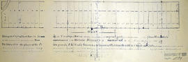
Blueprints - Belleville City Hall
- CA ON00156 M/M450-1502
- Item
- 1986-1988
Part of Map collection
10 blueprints planning for the Belleville City Hall in Belleville, Ontario.
Bel-Con Design-Builders
Blueprints - Belleville City Hall
Part of Map collection
10 blueprints planning for the Belleville City Hall in Belleville, Ontario.
Bel-Con Design-Builders
Blueprints - John Street United Church
Part of Map collection
14 blueprints planing for the rebuilding of John Street United Church on Victoria Avenue in Belleville, Ontario.
Scale 1.25" = 1 foot. By 1) Wm. Watson, architect 2) Pease Foundry Company, Charlie Hyde.
Watson, William

Boundary Lines Survey of Sidney Township, Con. 1
Part of Map collection
A certified reproduction of the “Boundary Line Commissioners Survey of Sidney Township. First Concession and Broken Front, for the Victoria District.” The area contained includes; Sidney Township, Concession 1 and the Broken Front Lots # 5 to 38. Originally surveyed by John Emereson, P. L. S. and produced on June 6, 1841. This reproduction was made by the Archives of Ontario.
Donated by Walter I. Watson, P. L. S.
Emerson, John, P.L.S.
Boundary Lines Survey of Sidney Township, Con. 2
Part of Map collection
A certified reproduction of the “Boundary Line Commissioners Survey of the Second Concession of Sidney, for the Victoria District..” The area contained includes; Sidney Township, Concession 2, Lot Block A and Lots # 1 to 38. Originally surveyed by John Emerson, P. L. S. and produced on September 4, 1840. This reproduction was made on June 2, 1972 and approved by the Deputy Registrar.
Donated by Walter I. Watson, P. L. S.
Emerson, John, P.L.S.

Boundary Lines Survey of Sidney Township, Con. 3
Part of Map collection
A certified reproduction of the “Boundary Line Commissioners Survey of the Third Concession of Sidney, for the Victoria District.” The area contained includes; Sidney Township, Concession 3, Lots: Block A and Lots # 1 to 38. Originally surveyed by John Emerson, P. L. S. and produced circa 1841. This reproduction was made on June 5, 1972 and approved by the Deputy Registrar.
Donated by Walter I. Watson, P. L. S.
Emerson, John, P.L.S.

Boundary Lines Survey of Sidney Township, Con. 5
Part of Map collection
A certified reproduction of the “Boundary Line Commissioners Survey of the Fifth Concession of Sidney, for the Victoria District.” The area contained includes; Concession 5, Lot Block A and Lots # 1 to 32. Originally surveyed by Samuel M. Benson, D. P. S. and produced on November 25, 1840.
This reproduction was made on June 5, 1972 and approved by the Deputy Registrar.
Donated by Walter I. Watson, P. L. S.
Benson, Samuel Manson, D.P.S. & P.L.S.

Boundary Lines Survey of Sidney Township, Con. 9
Part of Map collection
A certified reproduction of the “Boundary Line Commissioners Survey of the 9th Concession of Sidney, for the Victoria District.” The area contained includes; the 9th Concession of Sidney Township, Block A and Lots # 1 to 38.. Originally surveyed by John Emerson D. P. S. and produced on July 18, 1842.
This reproduction was made on June 5, 1972 and approved by the Deputy Registrar.
Donated by Walter I. Watson, P. L. S.
Emerson, John, P.L.S.

Boundary Lines Survey of Thurlow
Part of Map collection
A certified reproduction of the “Boundary Line Commissioners Survey, Concession 1, Township of Thurlow, for the Victoria District.” The area contained includes; Thurlow Township, Concession 1, Lots # 5 to 31 and the Tyendinaga Mohawk Territory on the Southerly part of Lots # 28, 29, 30, 31 along the bayshore. Originally surveyed by John Emereson, P. L. S. and produced on December 27, 1841. This reproduction was made on June 5, 1972.
Donated by Walter I. Watson, P. L. S.
Emerson, John, P.L.S.

Burttdale Heights subdivision in Trenton
Part of Map collection
A certified reproduction of the "Burttdale Heights subdivision of Lots # 19 to 28 on East side of Reid Street. Reg'd plan no. 240, Trenton.” The area includes; Lots # 1 to 168, Block A-D, east of Reid Street and south of Hamilton Road, being Lot # 1 Concession 1, Township of Sidney. Surveyed by Ronald Benn, O. L. S. and signed October 14, 1964.
Donated by Walter I. Watson, P. L. S.
Benn, Ronald, O.L.S.
Canada – business & wages 1965
File contains newspaper clippings comparing wages and salaries across Ontario.
Canada Map Index 1 from the National Topographic System
Part of Map collection
A topographical map of Ontario from the Canada Index 1, Maps of the National Topographic System of Canada. Published by the Department of Mines and Resources (now the Department of Natural Resources). Dated July 1991. Scale 1:50,000.
Canada. Department of Natural Resources

Canada Mines and Technical Surveys
Part of Map collection
"Canada Mines and Technical Surveys" covering area in Ontario and Southwestern Quebec. Published 1954. Scale: 50 miles to 1 inch.
Canada. Department of Energy, Mines and Resources

Canadian National Railway System Map
Part of Map collection
"The Only Railway Serving All Ten Provinces of Canada:" a map showing the Canadian National Railway System in 1952. The map includes: Canadian National Railways, Grand Trunk Western Railroad Company, Central Vermont Railway Inc., Duluth, Winnipeg and Pacific Railway Company. Composed by C.N.R. Montreal. Scale 10/16 of an inch to 50 miles.
Donated by Bruce Polmanter.
C.N.R. Montreal
Canoe Routes in the Moira River Watershed
Part of Map collection
A double sided, folded map showing the location of canoe routes within the Moira River Watershed.
Moira River Conservation Authority

Part of Map collection
The original map is a tracing of the printed map by Samuel de Champlain from "Les Voyages" in 1613. In the 1616 map, more additions were made to the north and south due to increased colonization. It shows Lake Ontario, here called Lac St. Louis today is known as Georgian Bay, Lake Huron and the Great Lakes.
The map was purchased by John Carter Brown Library, July 1953. The library had received it from Arthur Rau, an antique bookseller in Paris. Reproduced by the Meriden Gravure Society in 1956.
Champlain Society
City of Belleville Aerial photographs 1980
Part of Map collection
Scale 1= 10000.
1) M440-2811. Belleville, Aerial Photo Map # TD29121Z. Photo showing Belleville east city limits to Murray Township Lot # 8, and north from 1st Concession to Hwy 401 Corridor. Dated July 20, 1978.
2) M440-2812. Belleville, Aerial Map # 808/14/1/6. Photo showing City of Belleville, Bay Bridge Road, Dundas West Road, Four Seasons Hotel, Zwicks Park, and Albert College. Dated 1980.
3) M440-2815. Belleville, West, Aerial Photo # 78-4411/16/191. Photo showing Dundas St. West and Belleville & St. James Cemeteries, Marshall Road, West Bridge St. & Highland Ave. Circa 1978-80.
4) M440-2816. Belleville, West (Central), Aerial Photo # 78-4412/16/58. Photo showing Victoria Island, College Street, Drive in Theatre at West Bridge Street and Palmer Road, Village Dr. & Cascade Blvd. Circa 1978-80.
5) M440-2817. Belleville, East, Central- Photo # 78-4412/16/60. Photo showing the Bay of Quinte, Kiwanis Bayshore Park, Victoria Island, College St. and Bridge St. Circa 1978-80.
6) M440-2818. Belleville, North West, Aerial Photo # 78-4413/24/198. Photo showing MacClead Dam on Moira River in South East corner of photo; Hwy 401 at North on photo. Circa 1978-80.
7) M440-2819. Belleville, North East, Aerial Photo # 78-4413/24/200. Photo showing Victoria Ave., Jamieson Bone Road, Yardmen's Arena [Sports & Welliness Centre]. Circa 1978-80.
8) M440-2820. Belleville, East, Aerial photo #78-4412/16/62. Photo showing Bertram Blvd. and Bay of Quinte to Edge Hill Road & Stanley Park. Circa 1978-80.
Ontario Hydro
CNO Railway from Toronto to Ottawa 1910
Part of Map collection
A photocopy of a map detailing the CNO railway from Toronto to Ottawa. Dated November 15, 1910. Annotations of proprietors and boundaries have been added to the map.
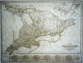
Copy of a Map of the Province of Ontario showing Railways
Part of Map collection
A reproduction of a "Map of the Province of Ontario Showing Railways now Running." A series of Toronto business advertisements line the bottom of the map. Originally published by the Canadian Almanac in 1884. Reproduced by COPP Clark Professional in January 1997 for the celebration of 150 continuous years of almanac and directory publishing.
Donated by the Belleville Public Library in 2014.
Copp Clark Limited
Counties from Belleville to Ottawa
Part of Map collection
A map showing counties from Belleville to Ottawa, Ontario, 1887. Published and donated by S.R.G. Penson.
Received from the Archives of Canada's map collection - 27 Jul. 1966.
Penson, S. R. G.
Department of Education report, 1870.
File contains a printed report on the education department by a select committee of the Legislative Assembly of Ontario, concerning the system of grammar and common schools in Ontario.