Marmora

Taxonomy

Code

Scope note(s)

Display note(s)

Hierarchical terms

Marmora

Marmora

Equivalent terms

Marmora

Associated terms

Marmora

25 Archival description results for Marmora

25 results directly related Exclude narrower terms

Alterations to the Plan of the Village of Marmora

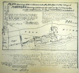
A certified reproduction of the "Alterations in Plan of part of Village of Marmora shewing additional lots laid out by T. P. Pearce on Lots # 7 & 8 in Concession 4 Township of Marmora.” Surveyed by C. Fraser Aylsworth Jr. P. L. S., and signed July 18, 1891.

This copy was made in 1972 of plan #285, as registered in the Hastings Land Registry Office.

Donated by Walter I. Watson, P. L. S.

Aylsworth, Charles Fraser Jr., O.L.S.

Crown sale grant of land in Marmora Township

  • 2022-039
  • Item
  • 1867

Province of Canada sale of Crown Lands (lot 15 in the fifth concession of Marmora Township) to John Fidlar, yeoman, of Marmora Township for $300.

Government of Canada

Harrowsmith Country Life

The file contains a copy of the magazine Harrowsmith Country Life, October 2003 Issue, No. 172 with the caption "Then & Now Photography; A Fond Look at the Changing Rural Landscape. On page 2 there is an article with pictures titled "The More Things Change; A black and white look at the changing character of rural Ontario."

Hastings with Town of Belleville and principal villages

A map of Hastings County including the Town of Belleville and other principal villages:

Trenton, Madoc, Marmora, Tweed, Bridgewater, Stirling, Wicklow, Bangor, Herschel, Monteagle, Carl, Dungannon, Wollaston, Limerick, Cashel, Tudor, Grimsthorpe, Elzevir; Rawdon, Huntingdon, Hungerford, Sidney, Thurlow, Tyendinaga.

Scale: 3 miles =1 inch. Published by John P. Evans, P.L.S. in 1869.

Evans, John Dunlop, P.L.S.

Lloyd's Map of Hastings County

A map of Hastings County outlining the twelve townships:
Marmora and Lake, Madoc, Tudor, Grimsthorpe, Elzevir; Rawdon, Huntingdon, Hungerford, Sidney, Thurlow, Tyendinaga. The northern townships are pictured on the right side.
As well as, the lots and concessions. Circa 1922. Scale: 1.5 miles: 1 inch. Published by Lloyd's Maps, Map Publisher.

Lloyd's Map, Map Publisher

Map of Belleville to North of Bancroft

A map containing focused maps of: Trenton, Belleville, Prince Edward County, Frankford, Picton, Bancroft, Deseronto, Stirling, Tweed, Marmora and Madoc. Insets refer to roads, streets and highways. Published by Millhouse Maps in 2001.

MIllhouse Maps

Map of Hastings County in 4 sections

A map of Hastings County outlining townships from the Bay of Quinte in the south, to Wallaston, Limerick and Cashel in the north.
Map is in four sections. Scale: 3 miles : 1 inch. Original map is dated 1894. Photocopy from the Archives of Ontario.

Map of Hastings with the Principal Villages and the City of Belleville

A map of Hastings County including the Town of Belleville and other principal villages:

Trenton, Madoc, Marmora, Tweed, Bridgewater, Stirling, Wicklow, Bangor, Herschel, Monteagle, Carl, Dungannon, Wollaston, Limerick, Cashel, Tudor, Grimsthorpe, Elzevir; Rawdon, Huntingdon, Hungerford, Sidney, Thurlow, Tyendinaga.

Scale: 3 miles =1 inch. Published by Evans & Bolger, P. L. Surveyors, P.L.S. in 1879-1880.

Evans and Bolger

Map of Hastings with townships

A map of Hastings County outlining the twelve townships:
Marmora and Lake, Madoc, Tudor, Grimsthorpe, Elzevir; Rawdon, Huntingdon, Hungerford, Sidney, Thurlow, Tyendinaga.
As well as, the lots and concessions. Circa 1916.Scale: 4 miles: 1 inch.

Donated by K.G.M. Ross.

Map of Marmora Township

Map showing concessions, traveled roads and lots of Marmora Township, Hastings County. Areas of gold mines are also charted. Scale: 1 mile : 1 inch. Published by MacLeod & Carre Engineers and Surveyors in Belleville, Ontario (Canada West). Local advertisements surround map.

Received from the Public Archives of Canada on 3 May 1971.

MacLeod and Carre, P.L.S.

Marmora : history

File contains a photocopied manuscript history of Marmora from ca. 1820 to 1965. Includes a hand-drawn map of the townsite. Also present is a photocopy of a one page extract from a survey of Midland District, 1822.

Warren, Grace

Marmora : history / by Grace Warren

File contains a photocopied manuscript entitled “History of Marmora,” by Grace Warren. Also contains a manuscript letter of explanation of the history from Ms. Warren to Carl Bateman, Hastings County Clerk. Also present is a photocopied excerpt from W.H. Smith's Canada: Past, Present and Future, outlining the history of Marmora Township and the Ironworks.

Warren, Grace

Pitceathly papers and deeds

File contains manuscript quit claims and deeds concerning the following properties:
i) part of lot number nine, eighth concession, Township of Marmora, purchased by James Madison Tuttle and Laura Maria Tuttle from Richard O. Rothwell, 30 May 1877;
ii)-west half of lot number sixteen in the fifth concession of the Township of Madoc purchased by George Dean Dickson and Marian Ellen Wilson Dickson from Thomas Comerford, 2 December 1882;
iii)-five acres on lot fifteen, fifth concession in the Township of Madoc, purchased by Thomas Comerford from David Pitceathly, Thomas Kelso et al, 11 June 1884;

Plan of Hastings for Hastings Directory

A map of Hastings County outlining townships:
Marmora, Lake, Madoc, Tudor, Grimsthorpe, Elzevir; Rawdon, Huntingdon, Hungerford, Sidney, Thurlow, Tyendinaga - as well as the northern townships.
Inset is "the Village of Marmora." Surveyed by H. A. F. Macleod, C.E. and P.L.S. Published by W. A. Little Lith., Montreal in the 1864-1865 copy of the Hastings Directory . Scale: 1:190,000.

MacLeod, Henry Augustine Fitzgerald, P.L.S.

Plan of Lot 6 in the Township of Marmora

A certified reproduction of the "Plan of Lot # 6 in the 4th Concession of Township of Marmora for Malcolm Cameron." Surveyed by John J. Haslett, P. L. S. and signed October 9, 1871.

This copy was made in 1972 of plan #150, as registered in the Hastings Land Registry Office.

Donated by Walter I. Watson, O.L.S.

Haslett, John James, P.L.S. & D.P.S.

Plan of Lots 7-9 in the village of Marmora

A certified reproduction of the Plan of Marmora Village - part of Lots # 7,8 & 9 in the 4th Concession of Marmora Township. The Marmora Foundry Company by Robert Symes, lawful agent, declares that this plan contains a true description. Depicted are; Coal houses; Grist Mill; Forge Store; and Mill dam. Surveyed by J. J. Haslett, P.L.S. and signed September 1855.

This copy was made in 1972 of plan #70, as registered in the Hastings Land Registry Office.

Donated by Walter I. Watson, O.L.S.

Haslett, John James, P.L.S. & D.P.S.

Plan of Summer Lots 10-11 in Township of Marmora

A certified reproduction of the "Plan of Summer Residence Lots as laid out on Lots # 10 and 11 and road allowance between these Lots, Concession 3, Township Marmora.” Surveyed by Fred Wilkins O. L. S., and signed October 9, 1908.

This copy was made in 1972 of plan #351, as registered in the Hastings Land Registry Office.

Donated by Walter I. Watson, P. L. S.

Wilkins, Frederick William Baiden, O.L.S.

Results 1 to 20 of 25