Madoc, Township of

Taxonomía

Código

Nota(s) sobre el alcance

Mostrar nota(s)

Términos jerárquicos

Madoc, Township of

Término General Hastings, County of

Madoc, Township of

Términos equivalentes

Madoc, Township of

Términos asociados

Madoc, Township of

50 Descripción archivística resultados para Madoc, Township of

50 resultados directamente relacionados Excluir términos relacionados

Hydro-Electric Power Commission of Ontario, Tweed-Section

  • CA ON00156 M/M430-2995 - 2996, 3018 - 3021, 3031/3018
  • Unidad documental simple
  • 16 Oct 1951
  • Parte deMap collection

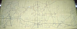
An original map produced for the Hydro-Electric Power Commission of Ontario, concerning hydro power lines, stations and transformers. However, the map also features railways, roads and land boundaries.

This map is the West Centre Section - Tweed ROA. The total area includes parts of Rawdon, Marmora, Huntingdon, Madoc, Hungerford, and Elzevir Townships. Dated October 16, 1951. Scale: 1.2 inches = 1 m.

Donated by David Pershik.

Plan of Hastings for Hastings Directory

  • CA ON00156 M/M420-1080
  • Unidad documental simple
  • 1864-1865
  • Parte deMap collection

A map of Hastings County outlining townships:
Marmora, Lake, Madoc, Tudor, Grimsthorpe, Elzevir; Rawdon, Huntingdon, Hungerford, Sidney, Thurlow, Tyendinaga - as well as the northern townships.
Inset is "the Village of Marmora." Surveyed by H. A. F. Macleod, C.E. and P.L.S. Published by W. A. Little Lith., Montreal in the 1864-1865 copy of the Hastings Directory . Scale: 1:190,000.

Sin título

Map of Hastings County in 4 sections

  • CA ON00156 M/M420-1090
  • Unidad documental simple
  • 1894
  • Parte deMap collection

A map of Hastings County outlining townships from the Bay of Quinte in the south, to Wallaston, Limerick and Cashel in the north.
Map is in four sections. Scale: 3 miles : 1 inch. Original map is dated 1894. Photocopy from the Archives of Ontario.

Map of the Counties of Hastings and Prince Edward

  • CA ON00156 M/M420-1093
  • Unidad documental simple
  • 1898
  • Parte deMap collection

A "Map of the Counties of Hastings and Prince Edward." In 1898, the lots, concessions, churches, schools and mines are shown of the townships in Hastings and Prince Edward. Scale: 1.5 miles to an inch. Published by the Canadian Map Publishing Company in Hamilton, Ontario, for the Belleville Sun. Revised by Henry Carre, C.E. Inset is the map of North Hastings, scale 400 chains to an inch.

Sin título

Minerals in northern Hastings County

  • CA ON00156 M/M420-1107
  • Unidad documental simple
  • 1943
  • Parte deMap collection

A map of northern Hastings County detailing different types of mineral occurrences, see Legend. Published in 1943 by the Ontario Department of Mines. Scale: 1:120,000. The map includes parts of Quebec and USA, in relation to the region. It was produced to "accompany report by Jas E. Thomson in Vol. LII Ontario Department of Mines, Annual Report, 1943."

Donated by the Ontario Department of Mines, April 1, 1965.

Sin título

Map of Belleville to North of Bancroft

  • CA ON00156 M/M420-1132
  • Unidad documental simple
  • 2001
  • Parte deMap collection

A map containing focused maps of: Trenton, Belleville, Prince Edward County, Frankford, Picton, Bancroft, Deseronto, Stirling, Tweed, Marmora and Madoc. Insets refer to roads, streets and highways. Published by Millhouse Maps in 2001.

Sin título

Map of Madoc Township

  • CA ON00156 M/M430-1155
  • Unidad documental simple
  • c.1869
  • Parte deMap collection

A map showing concessions and lots of Huntingdon - Madoc Township, Hastings County. Circa 1869. 30 advertisements for companies surround the map. Published by Macleod and Carre, Engineers and Surveyors. Scale: 1:63,000. Dimensions: 34.0cm x 37.0cm. Map was created from Government plan.

Donated from the Col. W. N. Ponton Estate. Penciled notes on map show Ponton family's interest in mining, especially after the Eldorado Gold Rush in 1866.

Sin título

Plan of Lot 2 in the Township of Madoc

  • CA ON00156 M/M430-1881
  • Unidad documental simple
  • 2 Feb 1876
  • Parte deMap collection

A certified reproduction of the "Plan of Lot # 2, Concession 5, Township of Madoc - the property of Thomas Cross." The Plan includes 30 subdivision Lots between St. Lawrence Street and the side line between Lots # 1 & 2, Concession 5, Madoc Township. Surveyed by Evans and Bolger, P.L.S., and signed February 2, 1876.

This copy was made in 1972 of plan #199, as registered in the Hastings Land Registry Office.

Donated by Walter I. Watson, P. L. S.

Sin título

Plan and Section of south Lot 18 in the Township of Madoc

  • CA ON00156 M/M430-1902
  • Unidad documental simple
  • Nov 1867
  • Parte deMap collection

A certified reproduction of the "Plan & Section of part of [the] south half of Lot # 18, Concession V, Township of Madoc, surveyed for Hugh R. Fletcher & T. D. Ledyard." The plan includes Lots on Richardson Ridge with Wellington Gold Mining Company and Richardson Mine. Surveyed by Murdoch Reid and Unwin, P. L. S. and signed November 1867.

This copy was made in 1972 of plan #121, as registered in the Hastings Land Registry Office.

Donated by Walter I. Watson, O.L.S.

Subdivision of part of east half of Lot 1 in the Township of Madoc

  • CA ON00156 M/M430-2035
  • Unidad documental simple
  • 13 Jan 1918
  • Parte deMap collection

A certified reproduction of the "Subdivision of part of the east half of Lot # 1, Concession 6, Township of Madoc & partly in Village of Madoc, property of W. H. McBain.” Surveyed by Henry Carre O. L. S., and signed January 13, 1914.

This copy was made in 1972 of plan #454, as registered in the Hastings Land Registry Office.

Donated by Walter I. Watson, P. L. S.

Sin título

Madoc : Hannah family genealogy

File contains a typescript extract from the Hastings County Court Registry Office concerning the ownership of a piece of land in Madoc Township, granted to C. Gordon Hannah in 1861. The lot is not identified, but information from the land index maintained by the Marilyn Adams Genealogical Research Centre suggest that it is lot 24 in the seventh concession of Madoc Township.

Lloyd's Map of Hastings County

  • CA ON00156 M/M420-1139
  • Unidad documental simple
  • c. 1922
  • Parte deMap collection

A map of Hastings County outlining the twelve townships:
Marmora and Lake, Madoc, Tudor, Grimsthorpe, Elzevir; Rawdon, Huntingdon, Hungerford, Sidney, Thurlow, Tyendinaga. The northern townships are pictured on the right side.
As well as, the lots and concessions. Circa 1922. Scale: 1.5 miles: 1 inch. Published by Lloyd's Maps, Map Publisher.

Sin título

Topographical plan of Lot 26 in the Township of Madoc

  • CA ON00156 M/M430-1695
  • Unidad documental simple
  • 18 Jul 1868
  • Parte deMap collection

A certified reproduction of a Topographical Plan of part of the east half of Lot 26, Concession 3, Township of Madoc. The Property of Donald Cameron. Surveyed by Forneri and Kennedy, P.L.S. and signed July 18, 1868.

This copy was made in 1972 of plan #125, as registered in the Hastings Land Registry Office.

Donated by Walter I. Watson, O.L.S.

Sin título

Part of east Lot 1 in the Township of Madoc

  • CA ON00156 M/M430-1959
  • Unidad documental simple
  • 17 Aug 1888
  • Parte deMap collection

A certified reproduction of "Plan of part of the east half of Lot # 1 in Concession 6, Township of Madoc.” Surveyed by C. Fraser Aylsworth Jr. P. L. S., and signed August 17, 1888.

This copy was made in 1972 of plan #273, as registered in the Hastings Land Registry Office.

Donated by Walter I. Watson, P. L. S.

Sin título

Plan of Rectification Survey of Madoc Township

  • CA ON00156 M/M430-2536
  • Unidad documental simple
  • 18 Mar 1891
  • Parte deMap collection

A certified reproduction of a “Plan showing the Rectification Survey... of the Township of Madoc.” The area contained includes; northern lots #30, 31, 32 on concessions 1-11 (inclusive) in Madoc Township. Originally surveyed by Charles Fraser Aylsworth, P. L. S. and produced on March 18, 1891.

This reproduction was made on June 5, 1972 and approved by the Deputy Registrar.

Donated by Walter I. Watson, P. L. S.

Sin título

Madoc Township Map # 446773E

  • CA ON00156 M/M470-2591 - 2616/2615
  • Unidad documental simple
  • c. 1950
  • Parte deMap collection

A reproduction of an air survey photograph produced by the Ontario Ministry of Natural Resources. Map #446773E of Madoc Township in Hastings County, Ontario. Circa 1950.

The photograph shows the northern part of Madoc Township, Bannockburn, Tudor Township, Concession 1 to 9, Robinson Lake, Westerly to Millbridge, Moira River, Highway 62, and the Canadian National Railway.

Donated by Walter I. Watson, P.L.S.

Sin título

Resultados 1 a 20 de 50