Limerick, Township of

Taxonomía

Código

Nota(s) sobre el alcance

Mostrar nota(s)

Términos jerárquicos

Limerick, Township of

Término General Hastings, County of

Limerick, Township of

Términos equivalentes

Limerick, Township of

Términos asociados

Limerick, Township of

22 Descripción archivística resultados para Limerick, Township of

22 resultados directamente relacionados Excluir términos relacionados

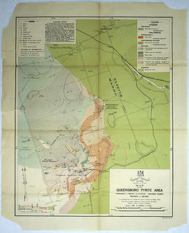
Map of the Queensboro Pyrite Area

  • CA ON00156 M/M430-3007
  • Unidad documental simple
  • 1913
  • Parte deMap collection

An original map of the Queensboro area, indicating specific geological areas and signs. Includes the Townships of Madoc and Elzevir in the County of Hastings, Ontario. Dated 1913. Published by the Ontario Department of Lands, Forests and Mines. Scale: 800 feet to an inch.

Donated by David Pershik.

Sin título

Minerals in northern Hastings County

  • CA ON00156 M/M420-1107
  • Unidad documental simple
  • 1943
  • Parte deMap collection

A map of northern Hastings County detailing different types of mineral occurrences, see Legend. Published in 1943 by the Ontario Department of Mines. Scale: 1:120,000. The map includes parts of Quebec and USA, in relation to the region. It was produced to "accompany report by Jas E. Thomson in Vol. LII Ontario Department of Mines, Annual Report, 1943."

Donated by the Ontario Department of Mines, April 1, 1965.

Sin título

Limerick Township : history

File contains a photocopy of a printed essay contributed by Mrs. G.V. Thompson, Mrs. Thomas Ham, and Mr. A. G. Giles, concerning early settlement, the erection of schools , lumbering and agricultural development of Limerick Township in the period from 1863 to ca. 1935. Also contains a two-page photocopied excerpt from the Hastings Directory, 1864-1865 listing landholders by concession and lot in Limerick Township. Includes a newsclipping from the Ontario Intelligencer announcing the opening of Limerick Central School in St. Ola in 1964.

Subdivision of free grant in the Township of Limerick

  • CA ON00156 M/M430-1934
  • Unidad documental simple
  • 26 May 1885
  • Parte deMap collection

A certified reproduction of the "Plan of subdivision of part of free grant Lots # 39 & 40. Lying east of the Old Hastings Road, Township of Limerick (on line between Concession 7 & 8) for Alexander Menzies.” Dated May 26, 1885.

This copy was made in 1972 of plan #244, as registered in the Hastings Land Registry Office.

Donated by Walter I. Watson, P. L. S.

Limerick Township 125th anniversary memorabilia

  • CA ON00156 2012-32
  • Colección
  • 2012

Commemorative calendar for 2012, program of celebratory events, pins for the 125th anniversary of Limerick Township in Hastings County, Ontario, PDF version of slideshow of vintage images shown at the 7 July 2012 event.

Sin título

Plan of subdivision of Lots 9-10 in St. Ola

  • CA ON00156 M/M430-1963
  • Unidad documental simple
  • 15 Oct 1887
  • Parte deMap collection

A certified reproduction of the "Plan of part of St. Ola, being subdivision of part of Lots # 9 & 10, Concession 1, Limerick Township laid out for Peter Perry Clark.” Surveyed by C. Fraser Aylsworth Jr. P. L. S., and signed October 15, 1887.

This copy was made in 1972 of plan #266, as registered in the Hastings Land Registry Office.

Donated by Walter I. Watson, P. L. S.

Sin título

Map of Limerick Township

  • CA ON00156 M/M420-2169 - 2183/M420-2180
  • Unidad documental simple
  • c. 1880
  • Parte deMap collection

A blueprint reproduction of a map of Limerick Township in Hastings County, Ontario. The map features the names of neighboring townships, lot and concession numbers, creeks, lakes (Salmon, Bass, Mud, etc.), and the Central Ontario Railway. The Hastings Road borders the west side of the township. Original map circa 1880. Scale 40 chains to an inch.

Mineral Map of the Gilmour Area

  • CA ON00156 M/M430-3006
  • Unidad documental simple
  • 1913
  • Parte deMap collection

An original map of the Gilmour area, indicating specific geological areas and signs. Includes the Townships of Limerick and Tudor in the County of Hastings, Ontario. Dated 1913. Published by the Ontario Department of Lands, Forests and Mines, with a compilation of information completed by W. R. Rogers.

Donated by David Pershik.

Sin título

McGeachie Conservation Area

  • CA ON00156 2014-13
  • Unidad documental simple
  • 2012

Booklet produced by the Friends of McGeachie about the McGeachie Conservation Area on Steenburg Lake in Limerick Township, Hastings County, Ontario.

Sin título

Correspondence of John Brett McGeachie and copy of 'Bass Lake' book

  • CA ON00156 2021-099
  • Colección
  • 1994-2003

Copy of McGeachie's book Bass Lake - Hastings County and correspondence between McGeachie and various authorities about the management of the McGeachie Conservation Area and his efforts to change the name of Steenburg Lake in Limerick Township, Hastings County, Ontario.

Sin título

Limerick Township : history / Mrs. Violet Carrol, St. Ola

File contains photocopies of typescript notes by Mrs. Violet Carrol, St. Ola concerning the geography, natural resources, settlement and agricultural and logging in Limerick Township (in response to a survey by Gerry Boyce for his book, Historic Hastings.. Also contains a manuscript letter from Violet Carrol to Carl Bateman, Clerk-Treasurer, Hastings County, concerning the history of Limerick Township.

Limerick Township : history / Mrs. Lavoy

File contains photocopies of typescript notes concerning the history, natural resources and early settlement, agricultural and industrial development of Limerick Township. Also contains a manuscript letter from Mrs. Lavoy to Gerry Boyce concerning lumbering in Carlow Township.

Resultados 1 a 20 de 22