Kingston

Taxonomie

Code

Bereik aantekeningen

ron aantekeningen

Toon aantekening(en)

Hiërarchische termen

Kingston

Kingston

Gelijksoortige termen

Kingston

Verwante termen

Kingston

34 Archivistische beschrijving results for Kingston

34 results directly related Exclude narrower terms

Military photographs from World War I

  • CA ON00156 2017-58
  • Collectie
  • 1916

Two photographs:

  1. Canadian Expeditionary Force, 155th O.S. Battalion at Barriefield, July 6, 1916 . A cropped version of the same image is available online here: https://upload.wikimedia.org/wikipedia/commons/2/25/155th_Battalion%2C_Barriefield%2C_July_6%2C_1916._No._498_%28HS85-10-32556%29.jpg
  2. Unidentified military unit standing on a large parade ground in an unnamed city, with a water tower in the background carrying an advertisement for Sweet Caporal Cigarettes. This image has been scanned and is available online at https://www.flickr.com/photos/cabhc/35460399302/

Slides of Belleville and Ontario scenes

  • CA ON00156 2021-041
  • Reeks
  • 1969-1971

Slides made by Rudolf Donninger during his time in Belleville, Ontario, working at Northern Electric. They include photographs of buildings in Belleville, rural scenes, cars, a parade and the Belleville Fair in 1970, winter scenes, Ottawa and Kingston views, and aircraft at the Trenton Air Show.

Zonder titel

Part of an architectural analysis of the Ford Block in Kingston

  • CA ON00156 DA 2013.03
  • Stuk
  • 2012

Part of an architectural analysis by Jennifer McKendry of the Ford Block at 165 Wellington Street, Kingston, Ontario, a building which was converted into a bank in 1895. The bank had a similar layout to the Bank of Montreal in Deseronto and the analysis includes a plan of the first floor of the bank.

Zonder titel

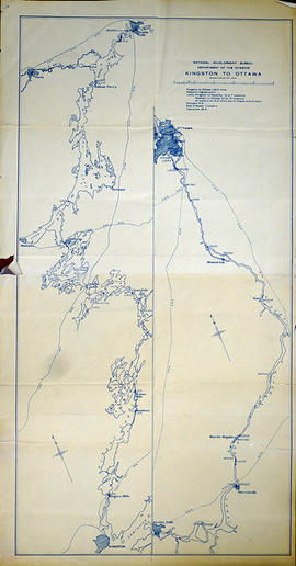
Map of Kingston to Ottawa

A map of Kingston to Ottawa, Ontario published by the National Development Bureau's Department of the Interior, circa 1930. The map features locks, bridges, waterways and settlements. Scale 2 miles to an inch. Written on the back, in ink, is "canoe trip." Presumably a tool of direction for someone's voyage.

Donated by the Belleville Public Library in 2014.

Zonder titel

Map of Presqu'ile to Kingston

A copy of an original map by Surveyor General John Collins showing land from Presqu'ile to Kingston in 1785. Scale: 4 miles : 1 inch.
Photocopied by the Archives of Canada 10 Jan 1990.

Zonder titel

Tourist Map of Land O' Lakes

A double-sided map of the accommodations, camping and attractions located in Land O' Lakes. Includes North & West of Kingston including Napanee, the Frontenacs, Loyalist Country & Mazinaw Country. Advertisements surround the map. Dated 1982.

Topographical Map of the Belleville to Kingston

A topographical map of the area between Belleville and Kingston. The total area extends from Prince Edward County to Buckshoot Lake North & South and from Havelock to Smith Falls East and West. Dated 1935. Published by the Department of National Defense.

Donated by Eric Jones.

Zonder titel

Topographical Map of Kingston - Canada sheet

A topographical map of the area, in Canada and the USA, surrounding Kingston. The total area extends from Norwood (west) to Smith Falls (east) and Buckshot Lake (north) to Picton (south). Dated 1958-1959. Published by the Army Survey Establishment.

Donated by the Belleville Public Library in 2014.

Zonder titel

Recreation Map of Land O' Lakes

A double-sided map of the accommodations, camping and attractions located in Land O' Lakes. Includes North & West of Kingston including Napanee, the Frontenacs, Loyalist Country & Mazinaw Country. Advertisements surround the map. Dated 1999.

Kingston

File contains:

  • The Globe, Toronto, ,July 30, 1892, 4 pages of pictures and history of Kingston
  • The Globe Magazine, June 15, 1957, 5 pages of pictures of Fort Henry, Kingston
  • The Telegram, November 7, 1959, clipping: Kingston - City of Gracious Living
  • Globe & Mail, April 11, 1957, clipping - Historic Simcoe House now a pile of timbers
  • Intelligencer, May 15, 1957 - Holleford Crater at Kingston believed caused by meteor over 500,000,000 years ago
  • Pamphlets: Old Fort Henry, Kingston; The Cathedral Church of St. George, Kingston; Queen's University Visitors' Guide
  • two Maps of town of Kingston, 1815 [very small]
Resultaten 1 tot 20 van 34