
- CA ON00156 TR/3716
- File
- c. 1880
File contains a diagram of Lot 19 Con. I, Twp of Madoc, Co. Hastings. Shows plots and names of owners. Names include Griffin, Broad, Morrison, Ferguson, and Hobson.
File contains a diagram of Lot 19 Con. I, Twp of Madoc, Co. Hastings. Shows plots and names of owners. Names include Griffin, Broad, Morrison, Ferguson, and Hobson.

Entry for Adult Writing Contest by Jean Elliott Cunningham. Includes photographs. 60 pages.
Cunningham, Jean Agnes

Entry for Historical Fiction Writing Contest by Wilfrid A. Forestell. Includes newspaper clipping. 7 pages.
Forestell, Wilfrid Aloysius

Entry for Historical Fiction Writing Contest by Eleanor Copeland.

Graham, Michelle "Cooper School" S.S. #6, Madoc Twp. H.C.H.S. Student Essay Contest
A report on the Cooper School written by 6th grader Michelle Graham for Madoc Township. Includes photographs and maps. 19 pages.

"The History of Burris School" S.S. #9, Madoc Twp. H.C.H.S. Student Essay Contest
A report on the Burris School written by 6th grader Sarah Ketchson for Madoc Township. Includes photographs.
Ketcheson, Sarah

McNeil, Lauri "Queensboro School" S.S. #3, Elzevir Twp. H.C.H.S. Student Essay Contest
A report on the Queensboro School written by 6th grader Laura McNeil for Madoc Township. Includes photographs and statistics. 14 pages.

Best, Rebecca Moore's School, Elzevir S.S. #4 H.C.H.S. Student Essay Contest
A report on the Moore's School written by 6th grader Rebecca Best for the Madoc Township. Includes photographs and maps. 10 pages.

Paranuik, Angela "Madoc Township School" H.C.H.S. Student Essay Contest
A report on the Madoc Township School written by 6th grader Angela Paranuik. Includes photographs and maps. 55 pages.
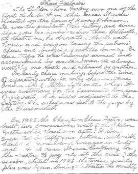
Madoc Township : history of cheese factories
File contains a photocopied brief manuscript history of cheese factories in Madoc Township.

Madoc Township : history of Bannockburn
File contains original and photocopied manuscript histories of the settlement and early development of Bannockburn including the lumbering and sawmilling industries. Includes a printout of a webpage on Maitland House (available on the Internet Archive's Wayback Machine at https://web.archive.org/web/20010805101431/http://casa-de.vrx.net/buildings/) and an article from the Fall 2019 Country Roads magazine about the conversion of St. Bartholomew Anglican Church in Bannockburn into a private home.

Madoc : Hannah family genealogy
File contains a typescript extract from the Hastings County Court Registry Office concerning the ownership of a piece of land in Madoc Township, granted to C. Gordon Hannah in 1861. The lot is not identified, but information from the land index maintained by the Marilyn Adams Genealogical Research Centre suggest that it is lot 24 in the seventh concession of Madoc Township.
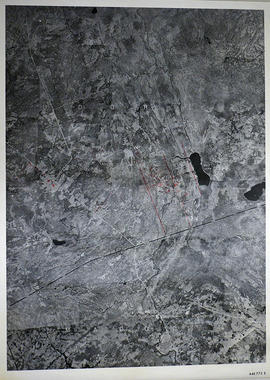
Part of Map collection
A reproduction of an air survey photograph produced by the Ontario Ministry of Natural Resources. Map #446773E of Madoc Township in Hastings County, Ontario. Circa 1950.
The photograph shows the northern part of Madoc Township, Bannockburn, Tudor Township, Concession 1 to 9, Robinson Lake, Westerly to Millbridge, Moira River, Highway 62, and the Canadian National Railway.
Donated by Walter I. Watson, P.L.S.
Ontario. Ministry of Natural Resources and Forestry

Part of Map collection
A reproduction of an air survey photograph produced by the Ontario Ministry of Natural Resources. Map #445772W of Madoc Township in Hastings County, Ontario. Circa 1950.
The photograph shows Madoc Township, Concession 5 to 9, Huntingdon Township Concession 14, northwest Elzevir Township, Queenboro and Black River.
Donated by Walter I. Watson, P.L.S.
Ontario. Ministry of Natural Resources and Forestry

Part of Map collection
A reproduction of an air survey photograph produced by the Ontario Ministry of Natural Resources. Map #445773E of Madoc Township in Hastings County, Ontario. Circa 1950.
The photograph shows Madoc Township, Concession 1 to 7, Hwy 62, and Moira River Watershed, Eldorado, Lake Township, Concession 3 to 10.
Donated by Walter I. Watson, P.L.S.
Ontario. Ministry of Natural Resources and Forestry
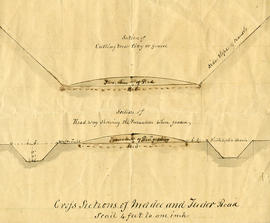
Part of Map collection
A cross-sectional plan regarding the formation of Madoc and Tudor Roads. Scale: 4 feet : 1 inch.

Plans for St Peter's Presbyterian Church
Part of Map collection
A set of plans for St. Peter's Presbyterian Church in Madoc, Hastings County, Ontario. The church itself opened in 1850. Scale: 8 feet : 1 inch.
Reproduction from the Archives of Ontario.

Plan of Norman Hill Subdivision in the Township of Madoc
Part of Map collection
A certified reproduction of Norman Hill subdivision of Park Lots # 1 & 2 of the Russell Estate - half of Lot # 2, 6th Concession of Madoc.
The Property of R. M. Norman Esq. Surveyed by C. F. Aylsworth Sr., P.L.S. and signed April 4, 1861.
This copy was made in 1972 of plan #119, as registered in the Hastings Land Registry Office.
Donated by Walter I. Watson, O.L.S.
Aylsworth, Charles Fraser Sr., P.L.S.

Plan of Eldorado Lots in the Township of Madoc
Part of Map collection
A certified reproduction of the Plan of Eldorado, Village & Mining Lots, as laid out on the northeast quarter of Lot # 17 in the 5th Concession of Madoc Township for John Moore. Surveyed by C. F. Aylsworth Sr., P.L.S. and signed January 2, 1867.
This copy was made in 1972 of plans #114, 115 and 115B, as registered in the Hastings Land Registry Office.
Donated by Walter I. Watson, O.L.S.
Aylsworth, Charles Fraser Sr., P.L.S.

Hastings with Town of Belleville and principal villages
Part of Map collection
A map of Hastings County including the Town of Belleville and other principal villages:
Trenton, Madoc, Marmora, Tweed, Bridgewater, Stirling, Wicklow, Bangor, Herschel, Monteagle, Carl, Dungannon, Wollaston, Limerick, Cashel, Tudor, Grimsthorpe, Elzevir; Rawdon, Huntingdon, Hungerford, Sidney, Thurlow, Tyendinaga.
Scale: 3 miles =1 inch. Published by John P. Evans, P.L.S. in 1869.
Evans, John Dunlop, P.L.S.