
- CA ON00156 CH/13/1/6
- Pièce
- 1884
Fait partie de County of Hastings records
Digital copy of 1884 Union Publishing Company's directory of the Counties of Frontenac, Hastings, Lennox, Addington, Prince Edward
Fait partie de County of Hastings records
Digital copy of 1884 Union Publishing Company's directory of the Counties of Frontenac, Hastings, Lennox, Addington, Prince Edward

Fait partie de County of Hastings records
Digital copy of 1899 Union Publishing Company's directory of the Counties of Frontenac, Hastings, Lennox, Addington, Prince Edward

Road Map of Prince Edward County 1955
Fait partie de Map collection
A road map of Prince Edward County in 1955. Portions of adjoining counties are also pictured. County boundaries are yellow, while roads are blue and red. Published by the Ontario Department of Highways. Scale: 1 inch = 4 miles.
Sans titre
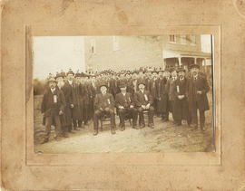
Ancient Order of United Workmen, Lodge 262 photograph
Photograph of members of the Ancient Order of United Workmen, Lodge 262 (Ameliasburgh) and two newspaper clippings from 1983 relating to the society.
Individuals identified are:
Seated: 1. ? Carnrite [Carnrike?]
James E. Glenn
Albert Lont
Dorland Fox
Dr. File M.D.
Moran Lont
Lewis Lont
Fred File
Gil Choat?
Byron Frederick
Ferris Wood
Francis Wood
John Tice
James A. Van Cott
William Bisdee
Charles Wood
Jessie Sprong
Albert Crosby
Will Reddick
Edgar Redner?
Fred Lauder?

West Lake Islands claimed by Alnwick Indians
Fait partie de Map collection
An original, waxed linen map entitled "Islands claimed by Alnwick Indians, Pursuant to Instructions bearing date Crown Lands, Dept. Quebec 2nd October 1861." The area in mention concerns the West Lake Islands, in Prince Edward County. Surveyed by Duncan McDonell Greenfield and John McNaughton, P. L. S. in May and June 1862. Scale: 8 chains to an inch.
Sans titre

Weller's and Hay Bay Islands claimed by Alnwick Indians
Fait partie de Map collection
An original, waxed linen map entitled "Plans of Islands claimed by the band of Alnwick Indians. Pursuant to Instructions bearing date “Crown Lands Department” Quebec 2nd October 1861." The area in mention concerns Weller's Bay and Hay Bay, in Prince Edward County. Surveyed by John McNaughton, P. L. S. in April and May 1862. Scale: 8 chains to an inch.
Sans titre

Topographic Map of Ontario - Belleville Sheet
Fait partie de Map collection
A map from the Eastern Canada series entitled "Topographic Map of Ontario - Belleville Sheet 31 C/3." The map includes Hastings County to Hillier in Prince Edward County. Published in 1938 by the Department of National Defence. Scale 1 inch to 1 mile.
Donated by the Belleville Public Library in 2014.
Sans titre

Map of the Counties of Hastings and Prince Edward
Fait partie de Map collection
A "Map of the Counties of Hastings and Prince Edward." In 1898, the lots, concessions, churches, schools and mines are shown of the townships in Hastings and Prince Edward. Scale: 1.5 miles to an inch. Published by the Canadian Map Publishing Company in Hamilton, Ontario, for the Belleville Sun. Revised by Henry Carre, C.E. Inset is the map of North Hastings, scale 400 chains to an inch.
Sans titre

Hydrographic Map of Bay of Quinte, Picton to Presqu'ile Bay
Fait partie de Map collection
A hydrographic map of the area surrounding the Bay of Quinte, Picton to Presqu'ile Bay in Ontario, Canada. With maps of Trenton Approaches, [racist slur redacted] Narrows, Belleville Harbour & Telegraph Narrows inset. Surveys completed in in 1952-53 and 1957. Map printed June 15, 1962. Published by the Canadian Hydrographic Service, Marine Sciences Branch, Department of Mines and Technical Surveys, Ottawa. Sheet number 2069.
Sans titre

Mullett, John & Family : pioneers of Prince Edward County
Fait partie de HCHS Textual Records collection: Files 2000 to 2499
File contains a newspaper article from The Picton Gazette concerning the life of the family of John Mullett, an early settler of Prince Edward County who established the Morocco Leather Company in Picton ca. 1833 on the site of the present Glenwood Cemetery.

Photographs of Norris Whitney Bridge construction
Nineteen photographs of the Norris Whitney bridge between Belleville and Rossmore, Ontario, under construction. Three were taken from the air when Ross Cummings was flying a Cessna 150 over the bridge.
Sans titre

Marysburgh; settlement 1784-1850
Fait partie de HCHS Textual Records collection: Files 1500 to 1999
File containing booklet on the history of the founding of Marysburgh and township council records from 1850-1.

Map of Hastings and Prince Edward Counties
Fait partie de Map collection
A map showing the roads, forts and inns of Hastings and Prince Edward Counties in 1850, by Major Baron DeRottenburg. The map extends from Brighton to Gananoque, Prince Edward County. and North to include Rawdon, Huntingdon, Hungerford Townships of Hastings County. Scale: 2 miles = 1". Dimensions 63cm x 44cm.
Sans titre

Map of District of Prince Edward County
Fait partie de Map collection
Map showing townships in the District of Prince Edward County: South Murray, Sidney, Thurlow, Ameliasburgh, Sophiasburgh. See boundary lines on map. Surveyed by Publius Virgillius Elmore, D.L.S. Dated 1835. Map copied from the Archives of Ontario.
Sans titre

Fait partie de Map collection
A map of Prince Edward County featuring information about local historical traditions, agriculture, community life and geography. Published in 1937 through Picton Times by Conger Allison. Dimensions: 72cm x 53cm.
Sans titre

Road Map of Hastings and Prince Edward Counties
Fait partie de Map collection
A map of Hastings and Prince Edward Counties from 1958. Titled "All roads lead to the City of Belleville and the Highlands of Hastings." Dimensions 19cm x 36cm.

COR Station at Bloomfield Plans
Fait partie de Map collection
A blueprint planning the COR passenger station at Bloomfield, Hastings County, Ontario. Plan features floor, platform plans, elevation and sections. Drawn by John Dunlop Evans, Chief Surveyor/Engineer - July 24, 1909.
Sans titre

Plans for COR Station at Hillier
Fait partie de Map collection
A blueprint of the proposed new COR station at Hillier, Prince Edward County, Ontario. Drawn by John Dunlop Evans, Chief Engineer. Published by the Office of Master of Bridges and Buildings G.T.R. on February 18, 1911.
Sans titre

Plans for COR Station at Picton
Fait partie de Map collection
A blueprint of the proposed new COR station at Picton, Prince Edward County, Ontario. Drawn by John Dunlop Evans, Chief Engineer. Published by the Office of Master of Bridges and Buildings G.T.R. in December 1901.
Sans titre

Plans for COR Station at Wellington
Fait partie de Map collection
A blueprint of the proposed new COR station at Wellington, Prince Edward County, Ontario. Drawn by John Dunlop Evans, Chief Engineer. Published by the Office of Master of Bridges and Buildings G.T.R. on March 23, 1911.
Sans titre