
- CA ON00156 2019-073
- Item
- c.1963
Booklet published by the Ontario Department of Lands and Forests, written by W. J. (Jack) Christie.
Ontario. Department of Lands and Forests
5 results with digital objects Show results with digital objects
Booklet published by the Ontario Department of Lands and Forests, written by W. J. (Jack) Christie.
Ontario. Department of Lands and Forests

Electoral Map of the Province of Ontario
Part of Map collection
An Electoral Map of the Province of Ontario, including all of the electoral districts outlined in red. Composed by Surveyor General F. W. Beatty. Published by the Ontario Department of Lands & Forests in 1955. Scale 8 miles to an inch.
Donated by the Argue family in 2013.
Ontario. Department of Lands and Forests
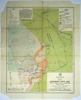
Map of the Queensboro Pyrite Area
Part of Map collection
An original map of the Queensboro area, indicating specific geological areas and signs. Includes the Townships of Madoc and Elzevir in the County of Hastings, Ontario. Dated 1913. Published by the Ontario Department of Lands, Forests and Mines. Scale: 800 feet to an inch.
Donated by David Pershik.
Ontario. Department of Lands and Forests
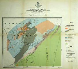
Mineral Map of the Gilmour Area
Part of Map collection
An original map of the Gilmour area, indicating specific geological areas and signs. Includes the Townships of Limerick and Tudor in the County of Hastings, Ontario. Dated 1913. Published by the Ontario Department of Lands, Forests and Mines, with a compilation of information completed by W. R. Rogers.
Donated by David Pershik.
Ontario. Department of Lands and Forests

Aerial View of Quinte Cruising Waters
Part of Map collection
A reproduction of a pre-1949 aerial view photo located in a tourism advertisement book. The booklet advertises Quinte's cruising waters extending from Trenton to Adolphus Reach.
Ontario. Department of Lands and Forests