- CA ON00156 2014-49/33
- Dossier
- 1910-1932
Fait partie de Smith family photographs
Black and white photographs of varying size. Photographs depict the building of a dam at Shaw Falls. Brief description written on each photograph.
34 résultats avec objets numériques Afficher les résultats avec des objets numériques
Fait partie de Smith family photographs
Black and white photographs of varying size. Photographs depict the building of a dam at Shaw Falls. Brief description written on each photograph.
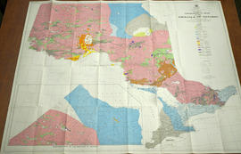
Geological Map of the Province of Ontario
Fait partie de Map collection
A Geological Map of the Province of Ontario published by the Ontario Department of Mines in 1958. Geology compiled by J. Satterly from published and unpublished maps of the Ontario Department of Mines, the Geological Survey of Canada, mining companies & technical publications (as per Legend). Scale 1 inch to 20 miles.
Sans titre
Canoe Routes in the Moira River Watershed
Fait partie de Map collection
A double sided, folded map showing the location of canoe routes within the Moira River Watershed.
Sans titre
Restoring Water Quality in the Bay of Quinte
Fait partie de Map collection
A double sided, folded map discussing pollution sources in the Bay of Quinte - where they are located, how they were created and how to clean up the pollutants.
Geological Map of the Madoc and Gananoque areas
Fait partie de Map collection
2 maps showing geological areas in Madoc (Map No. 2053) and Gananoque (Map No. 2053). Scale 1 in to 2 miles. Booklet by D. F. Hewitt, Senior Geologist, Ontario Department of Mines, Toronto.
Sans titre
Geological Maps of Hastings and surrounding counties
Fait partie de Map collection
Various maps of the Precambrian, Quarternary, and Paleozoic geology in Northumberland, Frontenac, Hastings, Lennox and Addington counties.
Sans titre

Subdivision of part of Lot 3 in the Township of Wicklow
Fait partie de Map collection
A certified reproduction of the "Subdivision of part of Lot # 3, Concession 10, Township of Wicklow, prepared for Dept. of Lands & Forests.” The area includes; Lots # 1 to 12, Blocks A to D on the northwest shore of Papineau Lake. Surveyed by Michael J. McAlpine, O. L. S. and signed December 1, 1960.
Donated by Walter I. Watson, P. L. S.
Sans titre

Fait partie de HCHS Textual Records collection: Files 2000 to 2499
One issue from a series of semi-annual bulletins published by the Ontario Dept. of Planning and Development, concerning Moira River Conservation Authority activities.
Sans titre

Booklet published by the Ontario Department of Lands and Forests, written by W. J. (Jack) Christie.
Sans titre
Ponton, W.N. : mining correspondence re Lead Mines, Galena Properties, Hastings County
Fait partie de HCHS Textual Records collection: Files 2500 to 2999
File contains several manuscript and typescript letters originating from and received by W.N. Ponton concerning lands containing lead mines in Lake and Tudor Townships, Hastings County.
Sans titre
Bolger, Thomas Oliver - Provincial Land Surveyor
Fait partie de HCHS Textual Records collection: Files 3500 to 3916
File contains an original copy of a Report on Mining Lands, in Marmora & Elzevir, County of Hastings by Thomas Oliver Bolger, Provincial Land Surveyor, circa 1850
Sans titre
Mining : Geological Map of Ontario
Fait partie de HCHS Textual Records collection: Files 2000 to 2499
File contains a colour geological map of the province of Ontario ca. 1958, displaying the rock composition underlying the soil throughout the province.
Fait partie de HCHS Textual Records collection: Files 2000 to 2499
File contains a photocopied typescript list of mineral samples from Hastings County possibly in the collections of Glanmore House, Belleville.
Mining : report to the Provincial Government on Hastings County mineral resources, 1866
Fait partie de HCHS Textual Records collection: Files 2000 to 2499
File contains a printed report to the Legislative Assembly of the [United] Province of Canada concerning mines and minerals in Hastings County in 1866.
Mines and Minerals : Hastings County
Fait partie de HCHS Textual Records collection: Files 2000 to 2499
File contains several typescript reports and correspondence concerning the mineral resources and the treatment of ores, including gold, iron, and other minerals found in Hastings County. Also contains a printed prospectus of The Gladstone and Sulphuret Gold Mining Company of Ontario ca. 1881, which had temporary headquarters at Belleville.
Madoc Township : history of Eldorado
Fait partie de HCHS Textual Records collection: Files 2000 to 2499
File contains a copy of a manuscript account of the history of Eldorado in Madoc Township, with particular attention to the gold mining industry.
Fait partie de HCHS Textual Records collection: Files 2000 to 2499
File contains manuscript and typescript correspondence relating to potential leases and shareholders' interests in the Richardson Mine, Eldorado, Ontario. Also contains a printed circular to stockholders concerning the termination of the company's operations in 1868.
Mining : gold rush in Hastings County, 1897
Fait partie de HCHS Textual Records collection: Files 2000 to 2499
File contains a newspaper article concerning the discovery of gold in the Tweed and Actinolite areas in 1897.

Marmora Gold Mining Company : gold shares, 1884
Fait partie de HCHS Textual Records collection: Files 2000 to 2499
File contains two completed printed shares in The Marmora Gold and Iron Mining Company issued in 1883-1884.
Marmora Iron Works : memorial to the Governor-General re: Belleville to Marmora railway
Fait partie de HCHS Textual Records collection: Files 2000 to 2499
File contains a manuscript original and copy of a memorial submitted by the Hastings County Council to Sir Edmund Walker Head, Governor-General of British North America, ca. 1857 requesting a railroad connection between the Marmora Iron Works and Belleville to facilitate the shipment of ore and provide a stimulus to mining in Hastings County.