Thurlow – Land Settlement Neg. showing 1836 Mills
- CA ON00156 TR/2868
- Item
- 1958
File contains a photo negative made c. 1958, of Thurlow Township c. 1836.
173 results with digital objects Show results with digital objects
Thurlow – Land Settlement Neg. showing 1836 Mills
File contains a photo negative made c. 1958, of Thurlow Township c. 1836.

Map of Belleville by Evans & Bolger 1877
Part of Map collection
An 1877 map of Belleville, Hastings County, Ontario by Evans & Bolger, surveyors. Map includes a table showing dates of plans in the registry office with plan name, wards and dates.
Cannifton & The Holgate Family
This file contains a personal writing by Maribeth L. Bird of Belleville, dated 1983 and titled "Cannifton, The Seat of Thurlow Township, Hastings County, Ontario, Canada". It contains: a brief history of Cannifton and the people; several reproduced articles from the Intelligencer (death of a child, Clarence William Holgate), unveiling of a plaque in memory of Miss Mary Cowan, "Reminiscent of a Mark Twain Novel" by John Bateman. The majority of the book is a family genealogy starting with John and Mary Holgate, born in England and Scotland in the years 1791 and 1797. The family history also contains photocopies of family pictures.
Bird, Maribeth Lillian
File contains research material for Yeomans Genealogy; including excerpts from the 1851, and 1871 Census' for Hastings County. Family names include Yeomans, Osborn, Clapp.
The file contains a number of legal documents dating from 1907 through to 1929 pertaining to land ownership of various parcels of land including: Hastings Paper Mills (Township of Thurlow), Lazier Paper Mills, Belleville Paper Mills, Lazier Dam. Family names included in these documents are: Colon Bruce Burnham, John Bell, Thomas P. Birchall, Samuel J. Bull, Jonas Canniff, James Canniff, William James Craig, William Oliver Luscomb (wife Coralie), Samuel H. Traverton, S.A. Lazier, Robert Elliott Lazier, Alec Robertson, Charles Edward Ford, Albert Ford, Frederick Ford, Walter Ford, Mary Ford, Mary Fenwick, William Moore, Clara Yeomans, Mary Yoemans, Louis C. Yeomans, Alicia Fenton Russell Yeomans , Horace Yeomans.

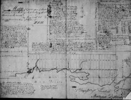
Sketch of the two front Concessions and Broken front of Thurlow
A concession survey sketch of Thurlow, signed by land surveyor Henry Smith.
Map of the First Concession of Thurlow
A map of the first concession of Thurlow, signed by land surveyor Henry Smith.
This file contains a copy of a school project written by Jim Chopman from Foxboro Sr. Elementary School. It is titled The History of the Ross Farm originally purchased from the Crown by Artimus Marsh Ross U.E.L. and 600 acres located in the Township of Thurlow, 4th and 5th Concessions circa 1800.
This file contains a copy of a school project written by Lana Ray from Foxboro Sr. Elementary School. It is titled Floyd Ray's Farm and contains information about the history of the farm owned by Floyd Andrew Ray (Lot 19, 7th Concession, Township of Thurlow) purchased from the Outwaters family circa 1867.
Midland District Hastings County Report on Roads, Crt. of Quarter Sess. 1810-30
This file contains a ledger recording roads passed in the Midland District in the County of Hastings from 1810 to 1830. Allan McLean Esq. was acting as Clerk of the Peace of the District. https://en.wikipedia.org/wiki/Allan_McLean_(Upper_Canada_politician)
these were recorded by James Nichollas, Clerk of the Peace, Midland District.
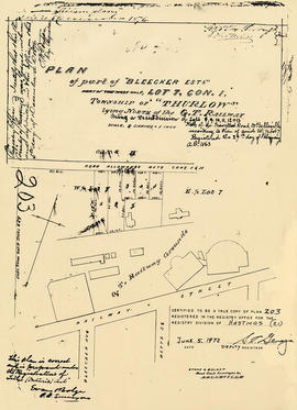
Plan of Bleecker Estate in the Township of Thurlow
Part of Map collection
A certified reproduction of the "Plan of part of Bleecker Estate, part of west half of Lot # 7 in 1st Concession Thurlow.” The Estate lay north of the Grand Trunk Railway being a re-subdivision of Lots # 8, 9, 10, 11 & 13. Surveyed by Evans and Bolger, P. L. S. Plan registered February 27, 1863.
This copy was made in 1972 of plan #203, as registered in the Hastings Land Registry Office.
Donated by Walter I. Watson, P. L. S.
Evans and Bolger

Map of Sidney and Thurlow Townships
Part of Map collection
This original map displays early township lots and proprietor names of Sidney and Thurlow Townships. Its date of creation is estimated to be between 1858-1863. Scale: 1:47,000.
Note that by observing the border, this map looks as if it was apart of a larger map. This is the only known copy.

Map of the Counties of Hastings and Prince Edward
Part of Map collection
A "Map of the Counties of Hastings and Prince Edward." In 1898, the lots, concessions, churches, schools and mines are shown of the townships in Hastings and Prince Edward. Scale: 1.5 miles to an inch. Published by the Canadian Map Publishing Company in Hamilton, Ontario, for the Belleville Sun. Revised by Henry Carre, C.E. Inset is the map of North Hastings, scale 400 chains to an inch.
Carre, Henry, O.L.S.

Resources Map of Hastings County
Part of Map collection
Resources map of Hastings County, Ontario, showing agricultural activity and natural resources.
Map of Thurlow and City of Belleville Wards
Part of Map collection
A double-sided map by the Belleville & District Chamber of Commerce. One side is the Thurlow Ward with major roadways and the location of two golf courses. On the flip side is the city of Belleville with its streets and 12 advertisements of local businesses.
Belleville Chamber of Commerce

Part of Map collection
A map of the Township of Thurlow, in 1787. Contains names of local property owners within their respective lots. Surveyed by Deputy Provincial Surveyor Lewis Kotte. Scale: 40 chains : 1 inch.
Kotte, Lewis

Subdivision of part Lot 3 in Thurlow Township
Part of Map collection
A plan of subdivision of part of Lot # 3, Concession 2, Thurlow Township, property of William Bleecker. Surveyed by P. L. Surveyor John D. Evans and signed November 24, 1873. Scale two chains to an inch.
Donated by the Glanmore National Historic Site in 2016.
Evans, John Dunlop, P.L.S.

Reproduced plan of Point Ann Railway
Part of Map collection
A photocopy of the "Plan of the Point Ann Railway in the Township of Thurlow and County of Hastings and Province of Ontario." The area includes from the Grand Trunk Railway, Lots 13-16 Concession 1, Lots 16-19 Broken Front Concession and south to the Bay of Quinte. Originally printed January 17, 1903. Scale 400 feet to an inch. Surveyed by Henry Carre, O. L. S.
Donated by the Belleville Public Library in 2014.
Carre, Henry, O.L.S.
Reproduced plan of Thurlow Railway Company Location
Part of Map collection
A photocopy of the "Thurlow Railway Company Location Plan Profile & Book of Reference, Province of Ontario." The area included extends from Lehigh Portland Cement Co. in Point Ann, First Concession of Thurlow Township and Lot # 23.
Buiy, Rayman R.

Map of Hastings with the Principal Villages and the City of Belleville
Part of Map collection
A map of Hastings County including the Town of Belleville and other principal villages:
Trenton, Madoc, Marmora, Tweed, Bridgewater, Stirling, Wicklow, Bangor, Herschel, Monteagle, Carl, Dungannon, Wollaston, Limerick, Cashel, Tudor, Grimsthorpe, Elzevir; Rawdon, Huntingdon, Hungerford, Sidney, Thurlow, Tyendinaga.
Scale: 3 miles =1 inch. Published by Evans & Bolger, P. L. Surveyors, P.L.S. in 1879-1880.
Evans and Bolger