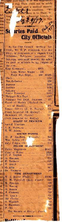
Belleville City Council salaries paid 1917
- CA ON00156 TR/0432
- File
- 1917
File contains a newspaper clip of the salaries paid to City of Belleville officials, published 20 February 1917.
Belleville City Council salaries paid 1917
File contains a newspaper clip of the salaries paid to City of Belleville officials, published 20 February 1917.
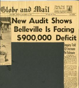
Belleville Council business – financial crisis re McFarlands 1959
File contains newspaper clips from the Globe and Mail c.1959 on the McFarland Hockey team scandal, Drury Denyes, Belleville's debt, and clips on the pending investigation and trial involving the City Council.

Belleville Council business – financial crisis regarding McFarlands in Telegram 1959
File contains newspaper clips c.1959 from the Telegram on the McFarland Hockey team scandal, Drury Denyes, Belleville's debt, and clips on the pending investigation and trial involving the City Council.
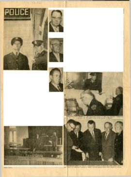
Belleville Police – New Station YMCA Building 1965
File contains the following newspaper clips on the Belleville police department c.1969: Belleville Police station officially open at old YMCA building, Hon. Roberts opens new police station, clip on Belleville police Chief Hugh MacKinnon, and other miscellaneous newspaper clips on the Belleville police station and department c.1969.

Mackenzie Bowell congratulatory message from Christian Advocate
File contains a newspaper clippling about Mackenzie Bowell being the first Prime Minister who is a member of the Methodist Church.

Newberry, Robert : City Clerk, Belleville 1873-81
File contains a brief typescript biography of Robert Newberry, City Clerk of Belleville from 1873 to his death in March of 1881.

Maps of the Districts of Upper Canada
Part of Map collection
4 maps showing the Districts of Upper Canada between 1788-1849:

Map of Hastings, Frontenac, Lennox and Addington 1850 reprint
Part of Map collection
Map showing Counties of Hastings, Frontenac, Lennox and Addington and the townships within. Legend shows boundaries of counties and townships, plank and graveled roads, other roads and canals. Surveyed by W. H. Smith. Published by MacLear. Scale 5 miles : 2 cm. Reprinted map from “Canada”: Past, Present, and Future. Original map dated 1850.
Smith, W. H.

New Railway and Commerical Map of Ontario
Part of Map collection
"New Railway and Commercial Map of Ontario:" a map showing the upper right corner of Ontario, 1887. It features information and reference to railways at the time. Published and donated by S.R.G. Penson.
Received from the Archives of Canada's map collection - 27 Jul. 1966.
Penson, S. R. G.

Map of District of Prince Edward County
Part of Map collection
Map showing townships in the District of Prince Edward County: South Murray, Sidney, Thurlow, Ameliasburgh, Sophiasburgh. See boundary lines on map. Surveyed by Publius Virgillius Elmore, D.L.S. Dated 1835. Map copied from the Archives of Ontario.
Elmore, Publius Virgillius, D.P.S.

Map of Districts of Prince Edward and Midland
Part of Map collection
Map showing counties, townships, concessions and lots in the Districts of Prince Edward and Midland. Surveyed by Publius Virgillius Elmore, D.L.S. Published by Hallowell U.C. Dated 1836. Scale 160 chains : 1". Map copied from the Archives of Ontario.
Elmore, Publius Virgillius, D.P.S.

Part of Map collection
Map showing lots in Sidney Township, 1878. Scale: about 50 chains to an inch.

Subdivision of Part of Lot #26 in the Township of Cashel
Part of Map collection
A certified reproduction of the "Subdivision of Part of Lot # 26, Concession V & VI, Township of Cashel, surveyed for Dept. of Lands & Forests.” The area includes; Lots # 1 to 13 on the West shore of Cashel Lake. Surveyed by N. H. Verhoef, O. L. S., Pierce & Pierce, O. L. S. and signed November 27, 1967. Scale: 1 inch = 100 ft.
Donated by Walter I. Watson, P. L. S.
Verhoef, N.H., O.L.S.

Subdivision of Part of Lots #28-29 in the Township of Cashel
Part of Map collection
A certified reproduction of the "Subdivision of part of Lots # 28 & 29, Concession VIll, Township of Cashel, surveyed for Dept. of Lands & Forests.” The area includes; Lots # 1 to 15 and Block “A” on the southeast shore of Lake Mephisto, being Lots # 28 & 29, Concession 8, Township of Cashel. Surveyed by N. H. Verhoef, O. L. S. of Pierce & Pierce, O. L. S. and signed November 29, 1967. Scale: 1 inch = 100 ft.
Donated by Walter I. Watson, P. L. S.
Verhoef, N.H., O.L.S.

Subdivision of Part of Lot #30 in the Township of Cashel
Part of Map collection
A certified reproduction of the "Subdivision of part of Lot #30, Concession VIll, Township of Cashel, surveyed for Dept. of Lands & Forests.” The area includes; Lots # 1 & 2 on the east shore of Lake Mephisto with the west side line between Lots # 30 & 31, Concession VIII, Township of Cashel. Surveyed by Michael Joseph McAlpine, O. L. S. and signed August 27, 1968. Scale: 1 inch = 100 ft.
Donated by Walter I. Watson, P. L. S.
McAlpine, Michael Joseph, O.L.S.

Subdivision of Part of Lots #16-17 in the Township of Mayo
Part of Map collection
A certified reproduction of the "Subdivision of part of Lots # 16 and 17, Concession V, Township of Mayo, surveyed for Dept. Lands & Forests.” The area includes; Lots # 1 to 4 on the northeast shore of [Little] Mayo Lake, being on part of Lot # 16 & 17, Concession V, Township of Mayo. Surveyed by Michael Joseph McAlpine, O. L. S. and signed August 1, 1967. Scale: 1 inch = 50 ft.
Donated by Walter I. Watson, P. L. S.
McAlpine, Michael Joseph, O.L.S.

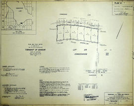
Subdivision of Part of Lots #27-28 in the Township of Bangor
Part of Map collection
A certified reproduction of the "Subdivision of part of Lots # 27 & 28, Concession XII, Township of Bangor surveyed for Dept. of Lands & Forests.” The area includes; Kamaniskeg Lake- Lots # 1 to 14 on the West and Northerly shore. Surveyed by Grange W. Elliott, O. L. S. and signed May 22, 1968. Scale: 1 inch = 100 ft.
Donated by Walter I. Watson, P. L. S.
Elliott, Grange W., O.L.S.
Subdivision of Part of Lot 28 in the Township of Bangor
Part of Map collection
A certified reproduction of the "Subdivision of part of Lot # 28, concession VII, Township of Bangor, surveyed for Dept. of Lands & Forests.” The area includes; Kamaniskeg Lake: Lots # 1 to 6 along the south shore on Lot # 28. Surveyed by Grange W. Elliott, O. L. S. and signed May 22, 1968. Scale: 1 inch = 100 ft.
Donated by Walter I. Watson, P. L. S.
Elliott, Grange W., O.L.S.

Subdivision of Part of Lot 21 in the Township of Bangor
Part of Map collection
A certified reproduction of the "Subdivision of part of Lot # 21, Concession XII, Township of Bangor, surveyed for Dept of Lands & Forests.” The area includes; Lots # 1 to 11 on the southwest shore of the Madawaska river being Lot # 21, Concession XII, Township of Bangor. Surveyed by Grange W. Elliott, O. L. S. and signed May 29, 1968.
Donated by Walter I. Watson, P. L. S.
Elliott, Grange W., O.L.S.

Subdivision of Part of Lot 28 in the Township of Bangor
Part of Map collection
A certified reproduction of the "Subdivision of part of Lot # 28, Concession XII, Township of Bangor, surveyed for Dept. of Lands & Forests.” The area includes; Lots # 1 to 14 and Blocks “A” and “B” on the west shore of Kamaniskeg Lake being part of Lot # 28, Concession XII, Township of Bangor. Surveyed by Grange W. Elliott, O. L. S. and signed February 7, 1969.
Donated by Walter I. Watson, P. L. S.
Elliott, Grange W., O.L.S.