Mostrando 111 resultados

Descripción archivística
Geographic features Con objetos digitales
Imprimir vista previa Hierarchy Ver :

Reproduction of a map of the province of Upper Canada

  • CA ON00156 M/M400-1002
  • Unidad documental simple
  • 12 April 1800
  • Parte deMap collection

Reproduction of a map showing new settlements, townships, counties etc.in the province of Upper Canada as of April 12, 1800. The total area spans from Quebec to Lake Huron and from Lake Michigan to New Hampshire then south to Pennsylvania in the U.S.A. This was the first printed map of Upper Canada, showing all settlements since 1784. Charted by D. W. Smith, Esq., Surveyor General London and published by W. Faden.

This map was published by Stonehouse Productions as part of "Charting Our Past" from the Archives of Ontario.

Sin título

Map of the principal settlements of Upper Canada (Part 2)

  • CA ON00156 M/M400-1004
  • Unidad documental simple
  • 1817
  • Parte deMap collection

Reproduction of Part 2 of a map showing a plan of the Principal Settlements of Upper Canada in 1817. The area covers from Northumberland to Essex counties.
This map can be found the Archives of Canada.

Maps of the Districts of Upper Canada

  • CA ON00156 M/M400-1010
  • Unidad documental simple
  • 1788-1849
  • Parte deMap collection

4 maps showing the Districts of Upper Canada between 1788-1849:

  1. Province of Upper Canada, original districts of 1788 and districts in 1802 (District boundaries 1788, dotted line, District boundaries 1802, solid line)
  2. Province of Upper Canada, original counties, ca. 1793
  3. Province of Upper Canada, districts in 1836
  4. Province of Canada West, districts in 1849

Map of Watersheds of the Moira and Napanee Rivers

  • CA ON00156 M/M410-1050
  • Unidad documental simple
  • 1950
  • Parte deMap collection

A map of the Watersheds of the Moira and Napanee Rivers, 1950. From the Department of Planning and Development by A. H. Richardson, Chief Conservation Officer. Dimensions: 48cm x 35.5cm.

Sin título

Map of Hastings, Frontenac, Lennox and Addington 1850 reprint

  • CA ON00156 M/M420-1079
  • Unidad documental simple
  • 1850
  • Parte deMap collection

Map showing Counties of Hastings, Frontenac, Lennox and Addington and the townships within. Legend shows boundaries of counties and townships, plank and graveled roads, other roads and canals. Surveyed by W. H. Smith. Published by MacLear. Scale 5 miles : 2 cm. Reprinted map from “Canada”: Past, Present, and Future. Original map dated 1850.

Sin título

Road Map of Hastings County 1956

  • CA ON00156 M/M420-1111
  • Unidad documental simple
  • 1956
  • Parte deMap collection

A road map of Hastings County in 1956. Portions of adjoining counties are also pictured. Boundaries are yellow, while roads are blue and red. Published by the Ontario Department of Highways. Scale: 1 inch = 4 miles. Dimensions: 72cm x 46.5cm.

Donated by Vera Crabbe in 2008.

Sin título

Road Map of Hastings County 1959

  • CA ON00156 M/M420-1115
  • Unidad documental simple
  • 1959
  • Parte deMap collection

A road map of Hastings County in 1959. Portions of adjoining counties are also pictured. Boundaries are yellow, while roads are blue and red. Published by the Ontario Department of Highways. Scale: 1 inch = 4 miles.

Sin título

Map of the Trent Port

  • CA ON00156 M/M430-1162
  • Unidad documental simple
  • 12 Jun 1837
  • Parte deMap collection

Map showing a sketch of the Trent Port - June 12th, 1837. Scale: 2 chains to an inch. Published by the Office of the Surveyor General.

From the Archives of Ontario in Toronto.

Map of Parcel of Area #1 - Land Settlement

  • CA ON00156 M/M440-1271
  • Unidad documental simple
  • 1881
  • Parte deMap collection

"In the High Court of Justice - Chancery Division - Morton vs. Ponton. Sketch of Parcel No. ,1 referred to in advertisement of sale therein. "

A map showing a parcel of land between the Bay of Quinte and Dundas Street East (Area #1) in Belleville, Ontario. Published in 1881. Used in land settlement matters. Printed on tissue paper. Scale: 8 chains to an inch.

Map of Dredging in Belleville Harbour

  • CA ON00156 M/M440-1278
  • Unidad documental simple
  • c. 1890
  • Parte deMap collection

A map detailing harbour improvements, specifically areas to be dredged, in Belleville, Ontario, post 1890. The areas to be dredged are hatched lines, see bottom right Legend. By J. W. Fraser. Scale: 400 ft : 1 inch.

Sin título

Topographical map of Bancroft - east half

  • CA ON00156 M/M470-1559 - 1573, 1576 - 1579, and 1585 - 1621/1559
  • Unidad documental simple
  • 1950
  • Parte deMap collection

A topographical map of Bancroft - Canada sheet #31 F/4, east half. Published by the Army Survey Establishment, Department of National Defence in 1950. Scale 1:50,000.

Donated by Gerry Boyce.

Sin título

Topographical map of Bancroft - east half

  • CA ON00156 M/M470-1559 - 1573, 1576 - 1579, and 1585 - 1621/1563
  • Unidad documental simple
  • 1956
  • Parte deMap collection

A topographical map of Bancroft - Canada sheet #31 F/4, east half. Published by the Army Survey Establishment, Department of National Defence in 1956. Scale 1:50,000.

Donated by Gerry Boyce.

Sin título

Topographical map of Mazinaw Lake

  • CA ON00156 M/M470-1559 - 1573, 1576 - 1579, and 1585 - 1621/1599
  • Unidad documental simple
  • 1947
  • Parte deMap collection

A topographical map of Mazinaw Lake - Canada sheet #31 C/14. Published by the Army Survey Establishment, Department of National Defence in 1947. Scale 1 inch to 1 mile = 1/63.360.

Sin título

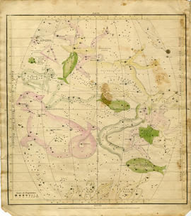
Geography of the Heavens - a Celestial Atlas

  • CA ON00156 M/M15000-1652
  • Unidad documental simple
  • 1833
  • Parte deMap collection

A "Celestial Atlas designed to illustrate the Geography of the Heavens" by Elijah Hinsdale Burritt, an American astronomer and mathematician. This second edition was published in 1833 by F. J. Huntingdon in the Clerk's Office of the District Court of Connecticut. The pages are as follows:

  1. "The visible heavens in October, November and December."
  2. "The visible heavens in January, February and March."
  3. "The visible heavens in April, May and June."
  4. "The visible heavens in July, August and September."
  5. "The visible heavens in the North polar region for each month of the year."
  6. "The visible heavens in the South polar region for each month of the year."
  7. "Planisphere of the whole heavens on Mercator's projection."

Sin título

Champlain Map of 1616

  • CA ON00156 M/M400-1653
  • Unidad documental simple
  • 1956
  • Parte deMap collection

The original map is a tracing of the printed map by Samuel de Champlain from "Les Voyages" in 1613. In the 1616 map, more additions were made to the north and south due to increased colonization. It shows Lake Ontario, here called Lac St. Louis today is known as Georgian Bay, Lake Huron and the Great Lakes.

The map was purchased by John Carter Brown Library, July 1953. The library had received it from Arthur Rau, an antique bookseller in Paris. Reproduced by the Meriden Gravure Society in 1956.

Sin título

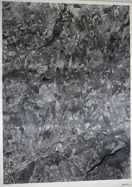
Sidney Township Map # 442773E

  • CA ON00156 M/M470-2591 - 2616/2591
  • Unidad documental simple
  • c. 1950
  • Parte deMap collection

A reproduction of an air survey photograph produced by the Ontario Ministry of Natural Resources. Map # 442773E of Sidney Township in Hastings County, Ontario. Circa 1950.

The photograph shows Sidney Township, Concession 1 to 8, Lots # 1 to 25, Hwy 33 and the Trent Canal and Frankford Village, southeast part of Murray Township.

Donated by Walter I. Watson, P. L. S.

Sin título

Murray Township Map # 442773W

  • CA ON00156 M/M470-2591 - 2616/2592
  • Unidad documental simple
  • c. 1950
  • Parte deMap collection

A reproduction of an air survey photograph produced by the Ontario Ministry of Natural Resources. Map # 442773W of Murray Township in Hastings County, Ontario. Circa 1950.

The photograph shows Concession 3 to 10 and Hickory Island of Murray Township, and Lots # 5 to 22, east part of Brighton Township.

Donated by Walter I. Watson, P. L. S.

Sin título

Tyendinaga Township Map # 443771W

  • CA ON00156 M/M470-2591 - 2616/2594
  • Unidad documental simple
  • c. 1950
  • Parte deMap collection

A reproduction of an air survey photograph produced by the Ontario Ministry of Natural Resources. Map # 443771W of Tyendinaga Township in Hastings County, Ontario. Circa 1950.

The photograph shows Lonsdale, Melrose and north to Concession 8, Township of Tyendinaga.

Donated by Walter I. Watson, P. L. S.

Sin título

Rawdon Township Map # 443772W

  • CA ON00156 M/M470-2591 - 2616/2596
  • Unidad documental simple
  • c. 1950
  • Parte deMap collection

A reproduction of an air survey photograph produced by the Ontario Ministry of Natural Resources. Map # 443772W of Rawdon Township in Hastings County, Ontario. Circa 1950.

The photograph shows the west part of Rawdon Township and the east part of Huntingdon Township.

Donated by Walter I. Watson, P. L. S.

Sin título

Seymour Township Map # 443773W

  • CA ON00156 M/M470-2591 - 2616/2598
  • Unidad documental simple
  • c. 1950
  • Parte deMap collection

A reproduction of an air survey photograph produced by the Ontario Ministry of Natural Resources. Map #443773W of Seymour Township in Northumberland County, Ontario. Circa 1950.

The photograph shows Seymour Township to the 10th Concession, including Percy Reach and Wilson Isle, Northumberland County.

Donated by Walter I. Watson, P.L.S.

Sin título

Resultados 1 a 20 de 111