Mostrando 26 resultados

Descripción archivística
Exploration, discovery and travel Imagen
Imprimir vista previa Hierarchy Ver :

26 resultados con objetos digitales Muestra los resultados con objetos digitales

Canadian National Railway System Map

  • CA ON00156 M/M400-3072
  • Unidad documental simple
  • 1952
  • Parte deMap collection

"The Only Railway Serving All Ten Provinces of Canada:" a map showing the Canadian National Railway System in 1952. The map includes: Canadian National Railways, Grand Trunk Western Railroad Company, Central Vermont Railway Inc., Duluth, Winnipeg and Pacific Railway Company. Composed by C.N.R. Montreal. Scale 10/16 of an inch to 50 miles.

Donated by Bruce Polmanter.

Sin título

Map of Hastings County and Road Changes

  • CA ON00156 M/M420-1658
  • Unidad documental simple
  • Jun 1915
  • Parte deMap collection

A map of Hastings County in 1914. Roads to be removed are highlighted in red colour. Published by the Office of Public Roads and Highways. Scale: 2 miles = 1". Dimensions: 54cm x 87cm.

Donated by Eric Jones, accession #2015-49.

Sin título

Road Map of the Province of Ontario 1953

  • CA ON00156 M/M425-1018
  • Unidad documental simple
  • 1953
  • Parte deMap collection

A road map of the northern and southern portions of the Province of Ontario. Published by the Ontario Department of Highways in 1953. Various indexes and legends are located on the map.

Sin título

Road Map of the Province of Ontario 1967

  • CA ON00156 M/M400-1023
  • Unidad documental simple
  • 1967
  • Parte deMap collection

A road map of the northern and southern portions of the Province of Ontario. Published by the Ontario Department of Highways in 1967 for the Centennial Year. Various indexes and legends are located on the map.

Sin título

Road Map of Hastings County 1953

  • CA ON00156 M/M420-1110
  • Unidad documental simple
  • 1953
  • Parte deMap collection

A road map of Hastings County in 1953. Portions of adjoining counties are also pictured. Boundaries are yellow, while roads are blue and red. Published by the Ontario Department of Highways. Scale: 1 inch = 4 miles.

Sin título

Map of Hastings County and Townships

  • CA ON00156 M/M420-1136
  • Unidad documental simple
  • c. 1950
  • Parte deMap collection

A map outlining Hastings County and the townships within. Neighboring counties are also present: Peterborough, Northumberland, Haliburton, Renfrew and Lennox and Addington. The Quinte region, including the cities of Belleville and Trenton are outlined at the bottom of the map.

Map of Hastings Highlands, Trenton and Belleville

  • CA ON00156 M/M440-1320
  • Unidad documental simple
  • 1966-1967
  • Parte deMap collection

A map of Hastings County in 1967, including; Hastings Highlands, Trenton and Belleville. Surveyed by D. John Emerson. Published by Canada Map Services.

Sin título

Map of the Great Lakes with French Missionary notes

  • CA ON00156 M/M400-2186
  • Unidad documental simple
  • 7 Jul 1882
  • Parte deMap collection

A map of Lake Ontario and the land surrounding it, with notes, presumably written by French explorers. Original date 1670, reprinted July 7, 1882.

Part of the Mika collection.

Map of British North America

  • CA ON00156 M/M400-2230
  • Unidad documental simple
  • 15 Feb. 1834
  • Parte deMap collection

A reproduction by the Canadian Department of Energy, Mines and Resources of "British North America by Permission dedicated to The Honorable Hudsons Bay Company containing the latest information which their documents furnish by their obedient servants." The map was originally composed by John Arrowsmith in 1834.

Donated by Gerry Boyce.

Sin título

"Things to see and do in Ontario" Map

  • CA ON00156 M/M400-3045
  • Unidad documental simple
  • 1961
  • Parte deMap collection

A map of Ontario detailing sports and activities located within the "Heart of Canada - Ontario - [an] easy to reach vacation land!" The "things to see & do" are located at different stops along the Trans-Canada Highway. Map dated 1961. Published for free distribution by the Department of Travel & Publicity of the Province of Ontario.

Sin título

Smith family photographs

  • CA ON00156 2014-49
  • Fondo
  • 1872-2000

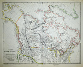
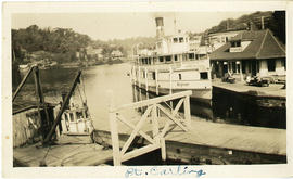
The fonds consists of 633 photographs, 23 negatives, letters, sympathy cards, business cards, newspaper clippings, genealogy and family history and a few business papers belonging to the Smith family, primarily Frank Smith of Madoc. The photographs found in this fonds mainly depict the area around Madoc, with some from Bancroft, Maynooth and other places in Hastings County. A large number of the photographs were taken on vacation or while travelling through Canada and the United States. The photographs were taken in Florida, Atlantic City, Pittsburgh, New Jersey, Philadelphia, Healy Falls, Shaw Falls, Coppercliffe, Ottawa, Port Carling, Gaspe, Napanee, Madoc, Bancroft, Manitoba, Saskatchewan and New Brunswick.

The families primarily depicted in the photographs are the Smith family, McCaw family, Swayne family and Cassidy family. Many of the photographs have names and places written on the back of them. Other people mentioned on the photographs include: Jean Phillips Thompson, Mary Smith Barton, Aunt Vera, Muriel Smith, George Wright, Hugh Pepper, Frank Smith, Frank and Jane Packer Ingersoll, Elizabeth Baker, Martin Porter, Kay Seaton, Helen Whycock, Bessie Woods, Tom Ross, Jack and Ann Yonkers.

There are 3 letters from Henry and Eliza Smith between 1872 and 1874; a birth certificate for Frank Smith, news clippings on the Smith and McCaw families and events in Madoc. There are also family trees and other genealogical information connecting the Smith, McCaw and other families. Much of the information appears to have been gathered by Mary Elizabeth Barton (born Smith: lived from 1921 to 2017).

Sin título

Townships of Hastings County with advertisements

  • CA ON00156 M/M420-1104
  • Unidad documental simple
  • 1932
  • Parte deMap collection

A map of Hastings County, in 1932, showing lakes, rivers, cities, towns and townships. A list of businesses within the county are on the right. Drawn exclusively for and published by Croydon Publishing Company.

Sin título

Tourist Map of Hastings County

  • CA ON00156 M/M420-1135
  • Unidad documental simple
  • c. 1940
  • Parte deMap collection

A tourist road map of Hastings County showing major highways, waterways, towns, cities and villages. Map is undated and from an unnamed tourist guide book. Circa 1940.

Note the absence of any 400 highways.

Information Guide Map of Belleville

  • CA ON00156 M/M440-1393
  • Unidad documental simple
  • c. 1961
  • Parte deMap collection

An information guide map of Belleville for visitors to the area. Map features points of interest within the southern part of the city. Circa 1961.

Sin título

Road Map of Central Canada 1939

  • CA ON00156 M/M400-3046
  • Unidad documental simple
  • 1939
  • Parte deMap collection

A map of Central Canada detailing various roads, towns and cities. The total area extends from west Sarnia to east Prescott and north Algonquin Park to south Lake Ontario. Map dated 1939. Published by Imperial Oil Limited. Scale: 15 miles to 1 inch.

Sin título

Road Map of the Province of Ontario 1956

  • CA ON00156 M/M400-1019
  • Unidad documental simple
  • 1956
  • Parte deMap collection

A road map of the northern and southern portions of the Province of Ontario. Published by the Ontario Department of Highways in 1956. Various indexes and legends are located on the map.

Sin título

Road Map of Prince Edward County 1955

  • CA ON00156 M/M425-1037
  • Unidad documental simple
  • 1955
  • Parte deMap collection

A road map of Prince Edward County in 1955. Portions of adjoining counties are also pictured. County boundaries are yellow, while roads are blue and red. Published by the Ontario Department of Highways. Scale: 1 inch = 4 miles.

Sin título

Resultados 1 a 20 de 26