"The Only Railway Serving All Ten Provinces of Canada:" a map showing the Canadian National Railway System in 1952. The map includes: Canadian National Railways, Grand Trunk Western Railroad Company, Central Vermont Railway Inc., Duluth, Winnipeg and Pacific Railway Company. Composed by C.N.R. Montreal. Scale 10/16 of an inch to 50 miles.
A map for recreation purposes, showing existing and proposed facilities in the Moira River watershed area. Not dated, circa 1950. Dimensions 47.5cm x 35cm.
A map of Hastings County in 1914. Roads to be removed are highlighted in red colour. Published by the Office of Public Roads and Highways. Scale: 2 miles = 1". Dimensions: 54cm x 87cm.
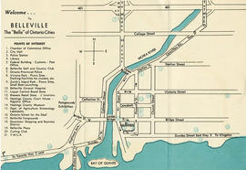
A map outlining Hastings County and the townships within. Neighboring counties are also present: Peterborough, Northumberland, Haliburton, Renfrew and Lennox and Addington. The Quinte region, including the cities of Belleville and Trenton are outlined at the bottom of the map.
A map of Hastings County in 1967, including; Hastings Highlands, Trenton and Belleville. Surveyed by D. John Emerson. Published by Canada Map Services.
A map of Central Canada detailing various roads, towns and cities. The total area extends from west Sarnia to east Prescott and north Algonquin Park to south Lake Ontario. Map dated 1939. Published by Imperial Oil Limited. Scale: 15 miles to 1 inch.
A road map of Hastings County in 1932. Portions of adjoining counties are also pictured. Boundaries are yellow, while roads are blue and red. Published by the Ontario Department of Highways. Scale: 1 inch = 4 miles. Dimensions: 40.7cm x 66cm.
A road map of Hastings County in 1953. Portions of adjoining counties are also pictured. Boundaries are yellow, while roads are blue and red. Published by the Ontario Department of Highways. Scale: 1 inch = 4 miles.
A road map of Hastings County in 1956. Portions of adjoining counties are also pictured. Boundaries are yellow, while roads are blue and red. Published by the Ontario Department of Highways. Scale: 1 inch = 4 miles. Dimensions: 72cm x 46.5cm.
A road map of Hastings County in 1959. Portions of adjoining counties are also pictured. Boundaries are yellow, while roads are blue and red. Published by the Ontario Department of Highways. Scale: 1 inch = 4 miles.
A road map of Hastings County in 1969. Portions of adjoining counties are also pictured. Boundaries are yellow, while roads are blue and red. Published by the Ontario Department of Highways. Scale: 1 inch = 4 miles.
A road map of Prince Edward County in 1955. Portions of adjoining counties are also pictured. County boundaries are yellow, while roads are blue and red. Published by the Ontario Department of Highways. Scale: 1 inch = 4 miles.
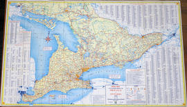
A road map of the northern and southern portions of the Province of Ontario. Published by the Ontario Department of Highways in 1953. Various indexes and legends are located on the map.
A road map of the northern and southern portions of the Province of Ontario. Published by the Ontario Department of Highways in 1956. Various indexes and legends are located on the map.
A road map of the northern and southern portions of the Province of Ontario. Published by the Ontario Department of Highways in 1967 for the Centennial Year. Various indexes and legends are located on the map.
A map of Ontario detailing sports and activities located within the "Heart of Canada - Ontario - [an] easy to reach vacation land!" The "things to see & do" are located at different stops along the Trans-Canada Highway. Map dated 1961. Published for free distribution by the Department of Travel & Publicity of the Province of Ontario.