- CA ON00156 M/M430-2628
- Item
- c. 2000
Part of Map collection
A map of Hastings County showing the location and information about local agriculture businesses relevant to autumn - orchards, bakeries etc.
Hastings Stewardship Council
24 results with digital objects Show results with digital objects
Part of Map collection
A map of Hastings County showing the location and information about local agriculture businesses relevant to autumn - orchards, bakeries etc.
Hastings Stewardship Council
Map of Belleville on the Bay of Quinte 2014-2015
Part of Map collection
A Map of Belleville on the Bay of Quinte, also including the surrounding areas of Picton in Prince Edward County. Advertisements border the map
Belleville Chamber of Commerce
Ontario Aerial photographs 1972-1977
Part of Map collection
Aerial photographs showing various townships within Ontario in the 1970s.

Seymour Power & Electric Co. Limited in Murray Township
Part of Map collection
An original map produced for the Seymour Power & Electric Co. Limited, concerning proposed transmission lines within the Township of Murray. However, the map also features railways, roads, mills and land boundaries. Circa 1910. Scale: 50 chains = 1 inch. Map composed by Smith, Kerry and Chace Engineers located in Toronto, Winnipeg, Calgary and Vancouver.
Donated by David Pershick.
Smith, Kerry and Chace Engineers

Trenton Electric & Water Co. Limited in Sidney Township
Part of Map collection
An original map produced for the Trenton Electric & Water Co. Limited, concerning proposed transmission lines within the Township of Sidney. However, the map also features railways, roads and land boundaries. Circa 1910. Scale: 50 chains = 1 inch. Map composed by Smith, Kerry and Chace Engineers located in Toronto, Winnipeg, Calgary and Vancouver.
Donated by David Pershick.
Smith, Kerry and Chace Engineers
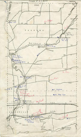
Map of Thurlow Township with annotations
Part of Map collection
A map of Thurlow Township featuring the addition of handwritten annotations. Concessions, railways, proprietors, businesses and locations are featured. The map extends from the Bay of Quinte in the southwest to Roslin the northeast. Circa 1950 (Bakelite plant opened c. 1948 and the Foxboro Cheese Factory closed in 1961).
Specific annotations are as follows: Halloway Grist Mill, Latta Bridge, Plainfield Grist, Saw Mill, O'Brien's Bridge, Grist Mill, Canning Factory Foxboro, Footbridge, Cheese Factory, Fairfields Bridge, Dam Corbyville, Distillery, Cannifton Dam, Grist & Saw Mill, Quarry & Substation, Round House, Brickyard, Graham's Dried Foods, Bell Telephone Lines, Hydro Power Lines, and Cement Works.

Part of Map collection
A map showing concessions and lots of Huntingdon - Madoc Township, Hastings County. Circa 1869. 30 advertisements for companies surround the map. Published by Macleod and Carre, Engineers and Surveyors. Scale: 1:63,000. Dimensions: 34.0cm x 37.0cm. Map was created from Government plan.
Donated from the Col. W. N. Ponton Estate. Penciled notes on map show Ponton family's interest in mining, especially after the Eldorado Gold Rush in 1866.
MacLeod and Carre, P.L.S.

Aerial View of Quinte Cruising Waters
Part of Map collection
A reproduction of a pre-1949 aerial view photo located in a tourism advertisement book. The booklet advertises Quinte's cruising waters extending from Trenton to Adolphus Reach.
Ontario. Department of Lands and Forests

Map of Railway Station, Harbour and Wharf Facilities
Part of Map collection
A map detailing the Grand Trunk Railway's station (1882), harbour and wharf facilities (1878) in Belleville, Ontario. Legends on each side of the maps describe buildings and areas. By William Michaud.
Michaud, William

Carre's Plan of the city of Belleville 1892
Part of Map collection
A copy of a map planning streets and buildings in Belleville, Ontario, 1892. The total area extends from Belleville to Bay of Quinte to Bridge Street (sheet 2) and from Bridge Street to Concession Road Allowance - now College Street - (sheet 1). Surveyed by Henry Carre, Ontario Land Surveyor.
Scale: 10 chains to an inch.
Carre, Henry, O.L.S.
Real Estate Board Map of Belleville and Trenton
Part of Map collection
A map featuring the streets in the City of Belleville and the Town of Trenton, as well as important buildings (e.g. schools, churches etc.).
Quinte and District Real Estate Board
Registered Plan Map of Belleville
Part of Map collection
A map of Belleville, Hastings County, Ontario and its properties and boundaries. Copyright 2006.
Maps of Belleville on the Bay of Quinte
Part of Map collection
Each map was published by the Ontario Mapping Company and features advertisements, streets, transit routes and points of interest.
1) M440-1367. Dated from 2000-2001. Scale 2.5 cm : 0.5 km. Composed by the Belleville & District Chamber of Commerce.
2) M440-1390. Dated from 2008-2009.
3) M440-1391. Dated from 2006-2007.
4) M440-1392. Dated from 2003-2004.
5) M440-1826. Dated 2010.
Ontario Mapping Company

Dominion of Canada with Hudson's Bay areas
Part of Map collection
A Map of the Dominion of Canada Shewing the Establishments of the Hudson's Bay Company. Scale: 1:10,500,00. Note the presence of the Districts of Mackenzie, Keewatin and Franklin and the border of Manitoba - circa 1905.
Map of Thurlow and City of Belleville Wards
Part of Map collection
A double-sided map by the Belleville & District Chamber of Commerce. One side is the Thurlow Ward with major roadways and the location of two golf courses. On the flip side is the city of Belleville with its streets and 12 advertisements of local businesses.
Belleville Chamber of Commerce
Plot Plan in the City of Belleville in 1960
Part of Map collection
A plan of a plot in the City of Belleville. Some of the buildings on site include Zellers, A and P, Reitmans. The plot is located between Dundas Street and Bridge Street. Published December 30, 1960 by Principal Investments Ltd., General Contractors.
Donated by the Belleville Public Library in 2014.
Copy of Fire Insurance Map 1878
Part of Map collection
1878 Fire Insurance Map from Charles Goad's Atlas. Details streets, buildings and lots in Belleville, Ontario. Donated by Beth Green.
Chas. E. Goad Company

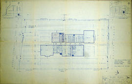
Floor plans for L. W. Yeoman's Drug Store
Part of Map collection
An original hand-painted, paper set of floor plans. The plan was drawn in 1873 for L. W. Yeoman & Company's drug store. The store was located on the corner of Front and Market Streets. The drawings cover the plans for the foundation, ground, second and third floors. Scale: 8 feet to one inch. Published by H. Belden & Company. John Forin built the building.
H. Belden & Company
Belleville Transit Bus Route Maps
Part of Map collection
Each map was published by the Belleville Transit Commission and features street names, transit routes and rider fares.
Belleville Transit Commission
Map of the Belleville Central Business District
Part of Map collection
A map of the Belleville Central Business District in Belleville from Church Street west to Moira River and from CPR north to Station Street.
Quinte Planning Board