Zwick's Island Park Project 1966-67
- CA ON00156 TR/3232
- Item
- 1966-1967
The file contains a series of newspaper articles from 1966 and 1967 about the development of Zwick's Island Park Centennial Project, Belleville.
174 results with digital objects Show results with digital objects
Zwick's Island Park Project 1966-67
The file contains a series of newspaper articles from 1966 and 1967 about the development of Zwick's Island Park Centennial Project, Belleville.
Part of Map collection
A map showing a zoning limits street plan within the City of Belleville. The zones and symbols can be referenced on the legend. The map was published on February 6, 1974.

Zoning Map of Belleville 1959-1970
Part of Map collection
A map showing, primarily, zoning limits within the City of Belleville. The limits are coloured in crayon and can be referenced on the legend (left). The map was first created c. 1959 (as written in pencil). However, more recent revisions were made June 4, 1970. Scale: 1:12,000. Additional information about by-laws is available on the map's border.
Note the two names listed on the top left corner: K. Murray and D. Williams - possible authors or owners.
Wooler District - Beetle (Wooden Mallet)
File contains a newspaper article from The Trentonian, dated November 23, 1960 titled "Wooler District Hunters Find Relic Of Bygone Days Near Gunter".
File contains several newspaper articles; one from The Ontario Intelligencer, dated July 20, 1933 and titled "The Old Church, the Ridge, In Wollaston Township"; from the Intelligencer, dated May 24, 1957 titled "Mrs. H.M. Hoard, Wollaston, Heads Assessors' Class"; one dated March 23, 1960 titled "Find of Copper Extends Into North Hastings".
File contains a newspaper article from The Woman's Globe and Mail, dated May 25, 1967 and titled "Windows To A City". The article is about historical buildings in Toronto and their windows.
Wilkins, Robert C. Carrying Place 1845
A deed to Robert C. Wilkins and Robert Shuter. 3 pages.
Wicklow Twp. Bangor, Wicklow, and McClure
Letters and notes written by Mrs. H. A. Fentie to Gerry Boyce on schools in Wicklow Township for his book Historic Hastings.
Watercolours of homes on West Hill, Belleville
Page with four watercolour paintings of homes, entitled "Grey Ladies - West Hill I Belleville". The four homes are 23 Charlotte Street, 8 Holloway Street, 114 Bridge Street West, 14-20 Murney Street, Belleville, Ontario.
Rector, Anne Elspeth
VHS video of Hastings County Administrative Building
Part of County of Hastings records
Tape labelled "Hastings County Administration Building, 235 Pinnacle Street, Belleville, Ontario, taped by Heritage Belleville, April /96". The video is 13 minutes and 30 seconds in length, and consists of a visual and audio survey by an unidentified female narrator of paintings and plaques inside and outside the Hastings County Court House and Administrative Building on April 4th, 1996.
Heritage Belleville
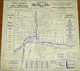
Vernon Mights Clearview Map of Belleville
Part of Map collection
A 1932 "Clearview" city directory map of Belleville, Ontario. The map features streets, water ways and major city buildings, as seen in the legend. Composed by Charles A. Mott, City Engineer. Published by Vernon Directories (Hamilton, Ontario) and Might Directories (Toronto, Ontario). Six advertisements also border the map.
Donated by Doctor Harold Reid.
Mott, Charles Allan

Vernon Clearview Map of Belleville c. 1940
Part of Map collection
A circa 1940 "Clearview" city directory map of Belleville, Ontario. The map features streets, water ways and major city buildings, as seen in the legend. Surveyed by Charles A. Mott, City Engineer. Published by Vernon Directories (Hamilton, Ontario). Heading of the map "Central Ontario Credit Exchange, The home of Collections, East Robertson Block, 219 Front Street, Licenced and Bonded Collection Specialists."
Mott, Charles Allan
This file contains three brochures, and numerous newspaper articles; regarding Upper Canada Village, Quinte – St. Lawrence Parks, and the history surrounding them.
United Empire Loyalists - Memorial Church Adolphustown
File contains an original copy of a booklet written by Rev. R.S. Forneri in 1888 entitled "The United Empire Loyalist and The Memorial Church, Adolphustown, Ontario". File also contains several newspaper clippings from 1959 about the Adolphustown Church.
United Empire Loyalists - Church Adolphustown
File contains a brief history on the U.E. Loyalist Memorial Church in Adolphustown.

File contains a newspaper article from the Intelligencer, dated 13-June-1967, titled “Woman's Penchant for Stone Houses Led to Purchase of Lonsdale Mill”.
Tweed Hydro-Electric Commission, History of
Five newspaper articles clipped from The Tweed News period from Jan 14, 1970 to Feb 11, 1970. Editorial history of Tweed Hydro-Electric Commission written by Cartha Cassidy, Commissioner. "Record of some of the significant happenings relating to the early history of electricity in Tweed and the march of Hydro in the community from 1930 until 1967 - Canada's Centennial Year."
Cassidy, Cartha
File contains a number of newspaper articles about Ontario's smallest jailhouse in Tweed, Ontario
File contains a newspaper article dated 20-November-1961 titled "Fire Completely Destroys Tweed Steel Works Plant".
Tuttle, Leslie : assignment of mortgage
File contains a completed assignment of mortgage to Dr. Leslie Tuttle, M.D. and Mary Edith Tuttle, Tweed dated 23 November 1897.