
Materials transferred from Glanmore National Historic Site
- CA ON00156 2019-071
- Collection
- 1728-1979
Various items from the collections of Glanmore National Historic Site.
Materials transferred from Glanmore National Historic Site
Various items from the collections of Glanmore National Historic Site.

An Accurate Map of Canada with the adjacent Countries
Part of Map collection
A reproduction by the Canadian Department of Energy, Mines and Resources of "An Accurate Map of Canada with the adjacent Countries Exhibiting the late Seat of War between the English & French in those parts." Original map was issued in 1761 at London. Includes the areas named; New South Wales, New Britain, Canada, south Louisiana, Virginia, "Pennsilvania," New York and New England. The names and location of Indigenous peoples are also featured on the map.
Donated by Gerry Boyce.
Canada. Department of Energy, Mines and Resources

Reproduction of Carte des Cinq Grands Lacs du Canada
Part of Map collection
Map showing "The 5 Big Lakes of Canada" by Jacques Nicholas Bellin, Paris, 1764. Bellin produced a maritime atlas containing this map, showing the topography, forts, portages and the Mission Ste. Marie in the Great Lakes area. This map was published by Stonehouse Productions as part of "Charting Our Past" from the Archives of Ontario.
Bellin, Jacques Nicolas

A New and Accurate Map of Part of North America
Part of Map collection
A reproduction of "A New and Accurate Map of Part of North-America, Comprehending the Provinces of New England, New York, Pennsilvania, New Jersey, Connecticut, Rhode Island & Part of Virginia, Canada and Halifax, For the Illustration of M. Peter Kalms Travels." Written at the bottom is "Publish'd according to Act of Parliament Mrahc 7th, 1771."

The Wanamaker fonds consists of textual records and graphic materials of genealogical histories of various families. The fonds also contains records, brochures, pamphlets, publications, books, and other textual records from towns and cities throughout Ontario, predominantly from the Quinte Area and Hastings County.
Genealogical family research names:
Wanamaker, Castello Loral Roy

Copy of a Map of the Province of New York and Jersey
Part of Map collection
A reproduction of "A New & Accurate Map of the Province of New York and Part of the Jerseys, New England and Canada. Showing the Scenes of our Military Operations during the Prejant War- Also the New Erected State of Vermont." Originally published by J. Bow on October 31, 1780. Date of reproduction is unknown.
Donated by the Belleville Public Library in 2014.

Marysburgh; settlement 1784-1850
File containing booklet on the history of the founding of Marysburgh and township council records from 1850-1.

Map of Fredericksburg Township
Part of Map collection
A survey plan map of the Township of Fredericksburg, 1784. Contains names of local property owners and bodies of water. Composed by James Peachy, Lewis Kotte, Henry Holland and Samuel Jaffe. Scale: 40 chains in an inch. Dimensions: 53cm x 39cm.
Peachey, James, D.L.S.
Digital photographs of family history notes
Part of Scrapbooks, newspaper clippings, papers of the Dafoe, Lloyd and Reid families
Digital copies of notes on the family history of the Wilmot, Merritt, Chisholm and Wartman families, 1785-1940.

Maps, plans and diplomas relating to Belleville and Hastings County
Various maps, plans and diplomas relating to Belleville and Hastings County, Ontario
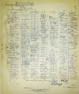
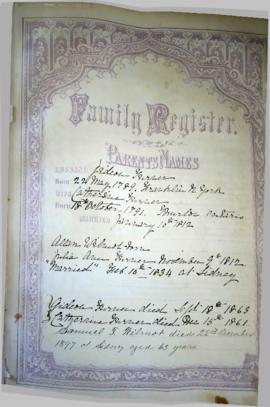
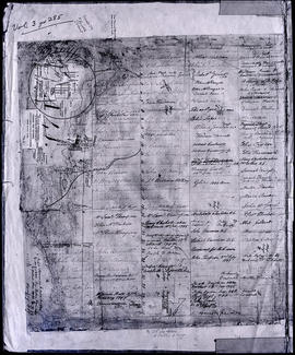
Map of Sidney Township in 1787 - 1981 rewrite
Part of Map collection
A recopy of the 1787 map of Sidney Township. The original map entitled "Plan of the Township of Sidney in the District of Mecklinburg. Surveyed in 1787 by Lewis Kotts, with the names of the proprietor inserted in the Lots." The recopy was completed by Mrs. Dorothy Ashton in 1981, for the Corby Public Library and Hastings County Historical Society. Scale 40 chains to an inch.
Donated by the Belleville Public Library in 2014.
Kotte, Lewis

Part of Map collection
A map of the Township of Thurlow, in 1787. Contains names of local property owners within their respective lots. Surveyed by Deputy Provincial Surveyor Lewis Kotte. Scale: 40 chains : 1 inch.
Kotte, Lewis

Part of Map collection
A map of Sidney Township, specifically the District of Mecklenburg in 1787. Contains information on the plans for the 1st, 2nd, and 3rd concessions, as well as property owners. Created by Lewis Kotte, Deputy Provincial Surveyor. Scale: 40 chains to an inch.
Kotte, Lewis
Map of Thurlow Township 1787 (with footnotes)
Part of Map collection
A land grant map of the Township of Thurlow, in 1787. Contains names of local property owners within their respective lots and concessions 1-4. Footnotes around the waterfront were added c.1960. Dimensions: 22cm x 28cm.

Maps of the Districts of Upper Canada
Part of Map collection
4 maps showing the Districts of Upper Canada between 1788-1849:

Reproduction of a map of Upper Canada
Part of Map collection
Reproduction of a map showing "the Routes Lt. Gov. J. G. Simcoe took on trips" throughout Upper Canada from March 1792 to September 1795. The map was charted by Lt. Gov. Simcoe. A good depiction of the area now referred to as Southern Ontario and his plans for a capital there - "London." This map was published as part of "Charting Our Past" from the Archives of Ontario by Stonehouse Publications.
Scale: about 20 miles to an inch.

Maps collected by the Hastings County Historical Society and added to by the Community Archives of Belleville and Hastings County. The maps cover locations in Hastings County and extend to all of Canada.
Hastings County Historical Society

Rawdon Township : diary of W. Hambly, 1793-1794
File contains a reproduction of a manuscript diary of W. Hambly, surveyor, for the period 6 December 1793 to 1 May 1794. The diary entries discuss the survey process in Thurlow, Sidney, Huntingdon and Rawdon Townships. Also present is a typescript transcript of the diary with an appended footnote section which contains a glossary of terms.

Proposed Towns and Military Roads of Upper Canada
Part of Map collection
Poor reproduction of a sketch of Upper Canada to show places designated by Lt. Gov. Simcoe for towns and proposed military roads, circa 1796. The map was published by B. M. Kings.

Map of Murray Township showing several lots
Part of Map collection
A copy of an original map by Surveyor General David W. Smith showing several lots of land in Murray Township in the District of Newcastle. Specifically, the map shows Lots 1-5 near the 1st Concession and River Trent. Published by Henry Smith on July 24, 1799.
Donated by K.G.M. Ross in 1963.
Smith, David William