Mostrando 188 resultados

Descripción archivística
Sidney, Township of
Imprimir vista previa Hierarchy Ver :

90 resultados con objetos digitales Muestra los resultados con objetos digitales

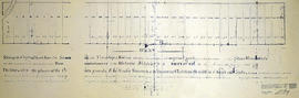
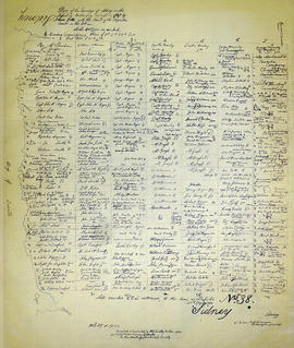
Map of Sidney Township in 1787 - 1981 rewrite

  • CA ON00156 M/M430-2391
  • Unidad documental simple
  • 1787
  • Parte deMap collection

A recopy of the 1787 map of Sidney Township. The original map entitled "Plan of the Township of Sidney in the District of Mecklinburg. Surveyed in 1787 by Lewis Kotts, with the names of the proprietor inserted in the Lots." The recopy was completed by Mrs. Dorothy Ashton in 1981, for the Corby Public Library and Hastings County Historical Society. Scale 40 chains to an inch.

Donated by the Belleville Public Library in 2014.

Sin título

Sidney : First Minutes of Township

File contains photocopied manuscript lists of persons nominated for township and parish officers in Sidney Township, 1790-1819. Also contains a newspaper article regarding the establishment of the Sidney Township Council and highlights of its proceedings to the 1930s. Also present is photocopied typescript outline of the history of Sidney Township and Trenton from ca. 1787-1819.

Map of Sidney Township 1787

  • CA ON00156 M/M430-1160
  • Unidad documental simple
  • 1787
  • Parte deMap collection

A map of Sidney Township, specifically the District of Mecklenburg in 1787. Contains information on the plans for the 1st, 2nd, and 3rd concessions, as well as property owners. Created by Lewis Kotte, Deputy Provincial Surveyor. Scale: 40 chains to an inch.

Sin título

Indenture

Sale of the eastern half of lot 37 in the second concession of Sidney Township by Anthony Ostrum of New York State, yeoman, to Roswell Leavens of Thurlow Township, blacksmith.

Midland District Hastings County Report on Roads, Crt. of Quarter Sess. 1810-30

This file contains a ledger recording roads passed in the Midland District in the County of Hastings from 1810 to 1830. Allan McLean Esq. was acting as Clerk of the Peace of the District. https://en.wikipedia.org/wiki/Allan_McLean_(Upper_Canada_politician)
these were recorded by James Nichollas, Clerk of the Peace, Midland District.

Map of District of Prince Edward County

  • CA ON00156 M/M420-1076
  • Unidad documental simple
  • 1835
  • Parte deMap collection

Map showing townships in the District of Prince Edward County: South Murray, Sidney, Thurlow, Ameliasburgh, Sophiasburgh. See boundary lines on map. Surveyed by Publius Virgillius Elmore, D.L.S. Dated 1835. Map copied from the Archives of Ontario.

Sin título

Boundary Lines Survey of Sidney Township, Con. 2

  • CA ON00156 M/M430-2530
  • Unidad documental simple
  • 4 Sep 1840
  • Parte deMap collection

A certified reproduction of the “Boundary Line Commissioners Survey of the Second Concession of Sidney, for the Victoria District..” The area contained includes; Sidney Township, Concession 2, Lot Block A and Lots # 1 to 38. Originally surveyed by John Emerson, P. L. S. and produced on September 4, 1840. This reproduction was made on June 2, 1972 and approved by the Deputy Registrar.
Donated by Walter I. Watson, P. L. S.

Sin título

Boundary Lines Survey of Sidney Township, Con. 5

  • CA ON00156 M/M430-2532
  • Unidad documental simple
  • 25 Nov 1840
  • Parte deMap collection

A certified reproduction of the “Boundary Line Commissioners Survey of the Fifth Concession of Sidney, for the Victoria District.” The area contained includes; Concession 5, Lot Block A and Lots # 1 to 32. Originally surveyed by Samuel M. Benson, D. P. S. and produced on November 25, 1840.

This reproduction was made on June 5, 1972 and approved by the Deputy Registrar.

Donated by Walter I. Watson, P. L. S.

Sin título

Boundary Lines Survey of Sidney Township, Con. 3

  • CA ON00156 M/M430-2531
  • Unidad documental simple
  • c. 1841
  • Parte deMap collection

A certified reproduction of the “Boundary Line Commissioners Survey of the Third Concession of Sidney, for the Victoria District.” The area contained includes; Sidney Township, Concession 3, Lots: Block A and Lots # 1 to 38. Originally surveyed by John Emerson, P. L. S. and produced circa 1841. This reproduction was made on June 5, 1972 and approved by the Deputy Registrar.
Donated by Walter I. Watson, P. L. S.

Sin título

Boundary Lines Survey of Sidney Township, Con. 1

  • CA ON00156 M/M430-2529
  • Unidad documental simple
  • 6 Jun 1841
  • Parte deMap collection

A certified reproduction of the “Boundary Line Commissioners Survey of Sidney Township. First Concession and Broken Front, for the Victoria District.” The area contained includes; Sidney Township, Concession 1 and the Broken Front Lots # 5 to 38. Originally surveyed by John Emereson, P. L. S. and produced on June 6, 1841. This reproduction was made by the Archives of Ontario.

Donated by Walter I. Watson, P. L. S.

Sin título

Boundary Lines Survey of Sidney Township, Con. 9

  • CA ON00156 M/M430-2534
  • Unidad documental simple
  • 18 Jul 1842
  • Parte deMap collection

A certified reproduction of the “Boundary Line Commissioners Survey of the 9th Concession of Sidney, for the Victoria District.” The area contained includes; the 9th Concession of Sidney Township, Block A and Lots # 1 to 38.. Originally surveyed by John Emerson D. P. S. and produced on July 18, 1842.

This reproduction was made on June 5, 1972 and approved by the Deputy Registrar.

Donated by Walter I. Watson, P. L. S.

Sin título

Resultados 1 a 20 de 188