Showing 57 results

Archival description
Stirling Item
Print preview Hierarchy View:

25 results with digital objects Show results with digital objects

Stirling history book

An unbound history of Stirling titled "The Heritage Years: A History of Stirling and District" , edited by Blanche Faulkner and Rosella Clancy, and published by the Stirling Historical Book Committee in 1984. It is 555 pages with photographs and an index. It is placed in three folders. (a,b,c).

Stirling Historical Book Committee

Air Surveys of Stirling, Ontario

All air surveys were completed in 1984 and published in 1985. Scale 1 inch = 2000 feet. By the Ontario Ministry of Natural Resources, Map base by Survey and Mapping Branch, Air Photography.

1) M470-2683. Stirling, Sheet # 1, 02-18-2960-49060 showing areas of; the Village of Stirling, Sidney Township Lot # 20, Concession 9, with Rawdon Creek along the Westerly section of the map.

2) M470-2684. Stirling, Sheet # 2, 02-018-2950-49070 showing areas of; the Village of Stirling, Lots # 18, 19, 20 Concession 9 of Sidney Township and Lots # 14, 13, 12 Concession 1, Rawdon Township.

3) M470-2685. Stirling, Sheet # 3A, 02-18-2960-49070 showing areas of; the Village of Stirling, Lots # 21, 22, 23 Concession 9, Sidney Township, Lot # 12 Concession 1, Rawdon Township. Also, the Mill Pond of Rawdon Creek on Lot # 10 & 11, Concession 1, Rawdon Township.

4) M470-2686. Stirling, Sheet # 3B, 02-18-2960-49070 showing areas of; the Village of Stirling, Lots # 21, 22, 23 Concession 9, Sidney Township, Lot # 12 Concession 1, Rawdon Township. Also, the Mill Pond of Rawdon Creek on Lot # 10 & 11, Concession 1, Rawdon Township.

5) M470-2687. Stirling, Sheet # 4, 02-18-2970-49070 showing areas of; the Village of Stirling and Sidney Township.

6) M470-2688. Stirling, Sheet # 5, 02-18-2960-49080 showing areas of; the Village of Stirling and Rawdon Township; Lots # 12, 11, 10 Concession 1.

7) M470-2689. Stirling, Sheet # 6, 02-18-2970-49080 showing areas of; the Village of Stirling and Rawdon Creek.

Ontario. Ministry of Natural Resources and Forestry

Plan of Survey of the Village of Stirling

A plan of survey of part of Blocks D & E, north of Church Street. Registered Plan 149 & Lots 1,2 & 3 Part of Lot # 4, south of Albert Street.

Miller, Paul A., O.L.S.

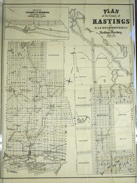
Plan of Hastings for Hastings Directory

A map of Hastings County outlining townships:
Marmora, Lake, Madoc, Tudor, Grimsthorpe, Elzevir; Rawdon, Huntingdon, Hungerford, Sidney, Thurlow, Tyendinaga - as well as the northern townships.
Inset is "the Village of Marmora." Surveyed by H. A. F. Macleod, C.E. and P.L.S. Published by W. A. Little Lith., Montreal in the 1864-1865 copy of the Hastings Directory . Scale: 1:190,000.

MacLeod, Henry Augustine Fitzgerald, P.L.S.

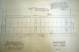
Plan of part of Lot 12 in the Township of Rawdon

A certified reproduction of the Plan of part Lot # 12 in 1st Concession of Rawdon, for proprietor Joseph Green. The lot is bounded by Marmora Road, Church Street. the Line between Concessions 11 & 12 and Front Street. Surveyed by John J. Haslett, P.L.S. and signed in December 1849.

This copy was made in 1972 of plan #52, as registered in the Hastings Land Registry Office.

Donated by Walter I. Watson, O.L.S.

Haslett, John James, P.L.S. & D.P.S.

Plan of Lot 23 in the village of Rawdon (Stirling)

A certified reproduction of the Plan of part of Rawdon (Stirling) Village, the north end of Lot # 23 in 9th Concession of Rawdon Township. A tannery is by the shore of Rawdon Creek and buildings are on Wright Street and John Street. An “Old Bridge” & a “New Bridge” extend over the Creek. Surveyed by John J. Haslett, P.L.S. in 1849.

This copy was made in 1972 of plan #54, as registered in the Hastings Land Registry Office.

Donated by Walter I. Watson, O.L.S.

Haslett, John James, P.L.S. & D.P.S.

Anniversary Notice

A letter from Belleville mayor George A. Zegouras to Mr. and Mrs. Cyrus Fulford on the occasion of their 60th wedding anniversary.

City of Belleville

Lloyd's Map of Hastings County

A map of Hastings County outlining the twelve townships:
Marmora and Lake, Madoc, Tudor, Grimsthorpe, Elzevir; Rawdon, Huntingdon, Hungerford, Sidney, Thurlow, Tyendinaga. The northern townships are pictured on the right side.
As well as, the lots and concessions. Circa 1922. Scale: 1.5 miles: 1 inch. Published by Lloyd's Maps, Map Publisher.

Lloyd's Map, Map Publisher

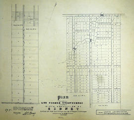
Plan of Lot 23 in the Township of Sidney (Stirling)

A certified reproduction of the Plan of Lot # 23 in 9th Concession of Sidney Township, including Park & Village Lots (in Stirling). Surveyed by J. J. Haslett, P.L.S. in 1859.

This copy was made in 1972 of plan #95, as registered in the Hastings Land Registry Office.

Donated by Walter I. Watson, O.L.S.

Haslett, John James, P.L.S. & D.P.S.

Plan of Park Lots 1, 12-14 and 26 in the village of Stirling

A certified reproduction of the Plan of Part of Village of Stirling for Edward Fidlar (Esqr.), showing the subdivision of Park Lots 1, 12, 13, 14, and 26. Surveyed by J. Emerson, P.L.S. and signed July 25, 1855.

This copy was made in 1972 of plan #77, as registered in the Hastings Land Registry Office.

Donated by Walter I. Watson, O.L.S.

Emerson, John, P.L.S.

Plan of subdivision of Lot 22 in the village of Stirling

A certified reproduction of the "Plan of subdivision in the Village of Stirling - Lot # 22, Concession 9, Sidney Township, on part of the property of E. F. Potts.” Surveyed by A. W. Ponton, P.L.S., and signed November 14, 1881.

This copy was made in 1972 of plan #226, as registered in the Hastings Land Registry Office.

Donated by Walter I. Watson, P. L. S.

Ponton, Archibald William, P.L.S. & D.L.S.

Plan of Block F Lots in the village of Stilring

A certified reproduction of the "Plan of Lots Laid out on Block F of Stirling - prepared for F. B. Parker; J. Clare Halliwell.” Surveyed by William R. Aylsworth O. L. S. and dated May 16, 1901.

This copy was made in 1972 of plan #326, as registered in the Hastings Land Registry Office.

Donated by Walter I. Watson, P. L. S.

Aylsworth, William Robert, O. L. S.

Results 1 to 20 of 57