Showing 1294 results

Archival description
Map collection
Print preview Hierarchy View:

897 results with digital objects Show results with digital objects

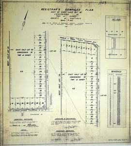
Registrar's Plan of part of Lots 12-15 in the Township of Hungerford

A certified reproduction of the "Registrar's Compiled Plan of parts of Lots # 12, 13, 14, 15...Township of Hungerford.” The area includes; Lots # 1 to 39, Block A-P along the shore of Stoco Lake, on the east side of the mouth of the Moira River and south of the former Canadian Pacific Railway now Trans Canada Trail and along Lake view Drive & Sunrise Road. Surveyed by Walter I. Watson, O. L. S. and signed June 23, 1965.

Donated by Walter I. Watson, P. L. S.

Watson, Walter Irvine, O.L.S.

Subdivision of island opposite Lot 24 in the Township of Cashel

A certified reproduction of the "Subdivision of island opposite Lot # 24, Concession IV, Township of Cashel, over High Pine Developments.” The area includes; Gunter Lake island Lots # 1 to 16 and Block A-B being opposite of Lot # 24, Concession IV, Township of Cashel. Surveyed by David M. Bews, O. L. S. (of McAlpine & Bews, O. L. S.) and signed July 13, 1966.

Donated by Walter I. Watson, P. L. S.

Bews, David Matthew, O.L.S.

Plan of Re-subdivision of Lot 7-24 in the Town of Trenton

A certified reproduction of the "Plan of Resubdivision of Lots # 7 to 24 inclusive and Lot # 48, Bowen Crescent, Downs Park Ave and Coulter Crescent as shown on Reg. Plan 775, Trenton, owner Downs Coulter & Co. (Canada) Ltd.” The area includes; Trenton- Lots # 7 to 31 on Coulter Crescent, North of Prince Charles School grounds and Westerly from Dufferin St. to Hanna Park. Surveyed by W. J. Pattison, O. L. S. and signed July 22, 1965.

Donated by Walter I. Watson, P. L. S.

Pattison, William James, O.L.S.

Registrar's Plan of Lot 33 in Sidney Township

A certified reproduction of the "Registrar's Compiled Plan of part of East half of Lot #33, Concession IV.” The area includes; part of the east half of Lot # 33, Concession IV, Sidney Township, Lot # 33 being between Wallbridge Loyalist Road on West and Philburn Rd. Surveyed by Ransom and Watson, O. L. S. and signed March 9, 1967.

Donated by Walter I. Watson, P. L. S.

Watson, Walter Irvine, O.L.S.

Registrar's Complete Plan of Lot 26 in Sidney Township

A certified reproduction of the "Registrar's compiled plan, part of Lot # 26, in Concession 1, Township of Sidney.” The area includes; part of Lot # 26, Concession 1, south of Canadian National Railway & Moira St. West. Registered March 10, 1967.

Donated by Walter I. Watson, P. L. S.

Graphic Index of Lots 37-38, Belleville

A certified reproduction of the "Registrar's Compiled Plan, being a graphic Index of Part of Lots # 37 and 38, Concession 1, Township of Sidney now City of Belleville.” The area includes;Lots # 1 to 50 Westerly from Sidney Street to Palmer Road and Northerly from Leland Drive to Bridge Street West. Surveyed by S. C. Geneja CST, Registry Office of Hastings and signed July 2, 1968.

Donated by Walter I. Watson, P. L. S.

Geneja, Stephen Conrad, CST

Subdivision of Block A in the Town of Trenton

A certified reproduction of the "Subdivision of Block “A”, Red. Plan no. 1210 and part of Park Lot # 15...Plan 240 Town of Trenton- owner Stanley Heights (Trenton) Ltd.” The area includes; Lots # 1 to 14, easterly from Sidney St. to Byron St. and northerly from Dixon Drive to Wilson Crescent. Surveyed by W. J. Pattison, O. L. S. and signed September 25, 1967.

Donated by Walter I. Watson, P. L. S.

Pattison, William James, O.L.S.

Subdivision of Earl's Court in the City of Belleville

A certified reproduction of the "Earls Court Subdivision part of Lots # 15 & 15, Reg. Plan 198, City of Belleville...owner R. H. Breault and Marian Vivien Breault” The area includes; Lot # 1 to 19 on Walmsley Place in the Earls court Subdivision East of Avondale Road.. Surveyed by Walter I. Watson, O. L. S. and signed December 15, 1968.

Donated by Walter I. Watson, P. L. S.

Watson, Walter Irvine, O.L.S.

Subdivision of part of Lots #17-19 in the Township of Tudor

A certified reproduction of the "Subdivision of part of Lots # 17, 18, 19, Concession 14, Part of Lot # 18, Concession 13 Township of Tudor, owner Jordon Lake Developments Ltd.” The area includes; Jordon Lake, Tudor Township, Lots # 1 to 22 and Block A and B and Streets: North Jordon Lake Road & South Jordon Lake Road being West of Hwy. 62. Surveyed by Edward C. Carter, O. L. S. and signed February 25, 1969.

Donated by Walter I. Watson, P. L. S.

Carter, Edward Christian, O.L.S.

Palmer Gardens Subdivision in the City of Belleville

A certified reproduction of the "Palmer Gardens subdivision...Registrar's compiled Plan 1824 formerly in Township of Sidney now Belleville.” The area includes; East of Palmer Road and Northerly from Leland Drive to Bridge St. West, being Lots # 1 to 126, Blocks A-K and streets Dunnet Boulevard, O'Hare St, Hope Crescent, Robertson Lane. Surveyed by Lloyd Parker, O. L. S. and signed April 25, 1969.

Donated by Walter I. Watson, P. L. S.

Parker, Lloyd Edward George, O.L.S.

Map of Southern Hastings County 1990

A map of the County of Hastings, Southern Portion, County Seat - Belleville. Published by the Ministry of Transportation and Communications, Ontario, in 1990.

Features: road jurisdictions, Kings Highways, secondary highways, township roads, roads legally open but not necessarily passable, urban corporate limits, railways and stations, township boundaries, county boundaries, populated areas.

Donated by the Belleville Public Library in 2014.

Ontario. Ministry of Transportation

Map of Hastings County with advertisements 1980

A presumed photocopy of a map of the County of Hastings, with advertisements, in 1980. Published by Graphic Publishers (Canada) of Toronto.

Donated by the Belleville Public Library in 2014.

Belleville Public Library

Road Map of Hastings County 1972

A road map of Hastings County in 1972. Portions of adjoining counties are also pictured. Boundaries are yellow, while roads are blue and red. Published by the Ontario Department of Transportation and Communications.

Donated by the Belleville Public Library in 2014.

Ontario. Ministry of Transportation

Map of Northern Hastings County 1971

A map of the County of Hastings, North Portion, County Seat - Belleville. Published by the Ministry of Transportation and Communications, Ontario. Revised in February 1971.

Features: road jurisdictions, Kings Highways, secondary highways, township roads, roads legally open but not necessarily passable, urban corporate limits, railways and stations, township boundaries, county boundaries, populated areas.

Donated by the Belleville Public Library in 2014.

Ontario. Ministry of Transportation

Results 1281 to 1294 of 1294