Showing 1294 results

Archival description
Map collection
Print preview Hierarchy View:

897 results with digital objects Show results with digital objects

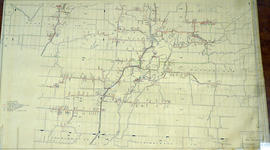
City of Belleville Map with Property Boundaries in 1981

A map of the City of Belleville, including property boundaries, waterways and roads. From the Moira River in the east to the Bay of Quinte south and CNR & North Front Street in the north to Avondale Road in the west. Map composed by the Quinte Planning Board and dated October 1, 1981. Scale 1:4800.

Donated by the Heritage Belleville Committee in 2017.

Quinte Planning Board

South City of Belleville Map with Property Boundaries in 1976

A map of the City of Belleville, including property boundaries, waterways and roads. House numbers are also included. From Bay of Quinte north to Bridge Street East and from the Moira River east to Foster Avenue. Map composed by the Quinte Planning Board and dated February 23, 1976. Scale 1:2400.

Donated by the Heritage Belleville Committee in 2017.

Quinte Planning Board

Layout of Buildings at County Court House

A General Layout of the Buildings at the Hastings County Court House on Pinnacle Street in Belleville, Ontario. All buildings are named. Composed by Charles D. Campbell, O.L.S, and dated October 16, 1927.

Donated by Heritage Belleville in 2017.

Campbell, Charles Donald, O.L.S.

First Floor Plan at County Court House

A Floor Plan of the Main First Floor at the County Court House on Pinnacle Street in Belleville, Ontario. All rooms and areas are named: Turnkey's Apartment, Sheriff's Offices, Judge Cameron's Office, Jail Govenor's Office etc. Composed by Charles A. Mott, City Engineer, and dated November 15, 1944.

Donated by Heritage Belleville in 2017.

Mott, Charles Allan

Plan of Elevations on Ponton Home in Belleville

A blueprint plan of the front and side elevations of the Veranda at the Ponton Home on west Dundas Street (Highway 2). Over the door "Quinte Cottage" is written. Drawn by John Arnold Thomson, Architect, and signed June 11, 1941. The house is now demolished.

Donated by the Heritage Belleville Committee in 2017.

Thomson, John Arnold

Site Plans for repairs at Sir James Whitney School

A set of architectural drawings of the Site Plan, Exterior Masonry, Water proofing and Foundation Repairs at Sir James Whitney School, 350 Dundas Street West, Belleville Ontario. Drawn by J. Mendoza, Licensed Professional Engineer, Province of Ontario - April, 2008.

Mendoza, J.

Architectural Plans of Superintendent's House at SJW School

A set of architectural drawings of the Superintendent's House Elevations, Floor Plans, and Roof Plan at Sir James Whitney School, 350 Dundas Street West, Belleville Ontario. Drawn by C. R. Mallette, Reg. Prof. Engineer - May 19, 2003.

Malette, C. R.

Downtown Area of the City of Belleville 1993

A map of the Downtown Area of the City of Belleville including building outlines and street addresses. The map covers Church Street east to Foster Ave and Edmund Street north to Pine St.

Grand Trunk and Grand Junction Trackage History

A photocopy of a map detailing Grand Trunk and Grand Junction Railways trackage and the history of it, at Belleville, Hastings County, Ontario. The map indicates the “Cross Over Diamond” Grand Junction Railway over Grand Trunk: approx November 1877, removed approx. August 1883. Researched and drawn by David L. Pershick - November 12, 1999.

Pershick, David

Hydro-Electric Power Commission of Ontario, Tweed-Section

  • CA ON00156 M/M430-2995 - 2996, 3018 - 3021, 3031/3018
  • Item
  • 16 Oct 1951
  • Part of Map collection

An original map produced for the Hydro-Electric Power Commission of Ontario, concerning hydro power lines, stations and transformers. However, the map also features railways, roads and land boundaries.

This map is the West Centre Section - Tweed ROA. The total area includes parts of Rawdon, Marmora, Huntingdon, Madoc, Hungerford, and Elzevir Townships. Dated October 16, 1951. Scale: 1.2 inches = 1 m.

Donated by David Pershik.

Hydro-Electric Power Commission of Ontario, Frankford Section

  • CA ON00156 M/M430-2995 - 2996, 3018 - 3021, 3031/3020
  • Item
  • c. 1950
  • Part of Map collection

An original map produced for the Hydro-Electric Power Commission of Ontario, concerning hydro power lines, stations and transformers. However, the map also features railways, roads and land boundaries.

This map is of the North Section - Frankford Rural Power District. The total area includes parts of Thurlow, Huntingdon, Sidney, Rawdon, Campbellford, Seymour, Brighton, and Percy Townships. Circa 1950.
Donated by David Pershik.

Hydro-Electric Power Commission of Ontario, Tweed Section

  • CA ON00156 M/M430-2995 - 2996, 3018 - 3021, 3031/3021
  • Item
  • 16 Oct 1951
  • Part of Map collection

An original map produced for the Hydro-Electric Power Commission of Ontario, concerning hydro power lines, stations and transformers. However, the map also features railways, roads and land boundaries.

This map is of the Southwest Section - Tweed Rural Power District. The total area includes parts of Hungerford, Huntingdon, and Thurlow Townships. Dated October 16, 1951. Scale: 2 inches = 1 mile.

Donated by David Pershik.

Seymour Power & Electric Co. Limited in Murray Township

  • CA ON00156 M/M430-2998 - 3001/M430-3000
  • Item
  • c.1910
  • Part of Map collection

An original map produced for the Seymour Power & Electric Co. Limited, concerning proposed transmission lines within the Township of Murray. However, the map also features railways, roads, mills and land boundaries. Circa 1910. Scale: 50 chains = 1 inch. Map composed by Smith, Kerry and Chace Engineers located in Toronto, Winnipeg, Calgary and Vancouver.

Donated by David Pershick.

Smith, Kerry and Chace Engineers

Trenton Electric & Water Co. Limited in Sidney Township

  • CA ON00156 M/M430-2998 - 3001/M430-3001
  • Item
  • c. 1910
  • Part of Map collection

An original map produced for the Trenton Electric & Water Co. Limited, concerning proposed transmission lines within the Township of Sidney. However, the map also features railways, roads and land boundaries. Circa 1910. Scale: 50 chains = 1 inch. Map composed by Smith, Kerry and Chace Engineers located in Toronto, Winnipeg, Calgary and Vancouver.

Donated by David Pershick.

Smith, Kerry and Chace Engineers

Map of the Queensboro Pyrite Area

An original map of the Queensboro area, indicating specific geological areas and signs. Includes the Townships of Madoc and Elzevir in the County of Hastings, Ontario. Dated 1913. Published by the Ontario Department of Lands, Forests and Mines. Scale: 800 feet to an inch.

Donated by David Pershik.

Ontario. Department of Lands and Forests

A Close Up of Southern Ontario, Ontario, and Canada

  • CA ON00156 M/M400-3036, 3038 - 3041, 3044/M400-3036
  • Item
  • Dec 1978
  • Part of Map collection

A map entitled "A Close Up of Southern Ontario, Ontario, and Canada" by the National Geographic Society's Cartography Section. Scale: 1 centimeter = 30 kilometers or 1 inch = 47.3 miles. Dated December 1978.

National Geographic Society

A Map of Canada, 1985

  • CA ON00156 M/M400-3036, 3038 - 3041, 3044/M400-3038
  • Item
  • Nov 1985
  • Part of Map collection

A map showing all of Canada by the National Geographic Society's Cartography Section. Scale: 1 centimeter = 69 kilometers or 1 inch = 109 miles. Dated November 1985.

National Geographic Society

Results 61 to 80 of 1294