An aerial photograph of Sidney Township, Concession 3 (Map # TD19689Z). The photo includes Concession 3 and part of Concession 4, Lots A, # 1 to 21, including proposed Hydro right of way and landowners names and instrument numbers. Photographed on September 10, 1973 and annotations made July 27, 1976. Scale 1 inch = 200 feet. For the Ontario Hydro Route and site Selection Division, Orthophoto R/W Selection Plan Lennox G. S. - Oshawa Area T. S. Aerial View. By J. E. Clements- photogrammetric production officer; D. Crozier- chief draftsman; J. Sedgwal- project engineer; C. E. Bishop- Sr R/W planning engineer.
Plan showing Sidney Township, part of Lot # 31, Concession 4, and the proposed right of way for Ontario Hydro Lines. (Map # TD30198D). For Ontario Hydro, Design and Construction Branch, Surveys and Mapping. Scale 1 inch = 60 feet. Drawn by R. Sweeney.
Plan showing Sidney Township, part of Lots # 25 to 29, concession 4 & part of Lot # 25, Concession 3, for proposed right of way for Ontario Hydro Lines (Map # TD30199Z). For Ontario Hydro, Design and Construction Branch, Surveys and Mapping. Scale 1 inch = 200 feet. Drawn by R. Sweeney.
Plan showing Tyendinaga Township, Part of Lots # 31 to 40, concession 2 North range, Ontario Hydro proposed right to way (Map # TD30189Z). For Ontario Hydro, Design and Construction Branch, Surveys and Mapping. Scale 1 inch = 200 feet. Drawn by R. Sweeney, R. A. Schan, O .L. S.
Plan showing Richmond Township, Lennox & Addington County, Lots # 8 -12, Concession 3 & Lots # 1 to 12, Concession 4 (Map # TD19683Z). For Ontario Hydro, Route and Site Selection Division Orthophoto R/W Selection Plan. Scale: 1 inch = 20 feet. By J. E. Clements-photogrammetric production officer.
Plan showing Cramahe Township, Northumberland County, Concession 8, Lots # 23 to 26 part of road allowance between Lots # 22 & 23, Concession 8 (Map # TD24778Z). For Ontario Hydro Transmission & Distribution projects, Division Orthophoto Title Study. Scale: 1 inch= 200 feet.
Plan showing Cramahe Township, Northumberland County, Concession 8, part Lots # 27 to 31. Aerial View of Ontario Hydro Project. (Map # TD24779Z). For Ontario Hydro Transmission & Distribution projects, Division Orthophoto Title Study. Scale: 1 inch= 200 feet.
Plan showing Cramahe Township, Northumberland County, Concession 8, Part Lots # 32 to 35 (Map # TD24780Z). For Ontario Hydro Transmission & Distribution projects, Division Orthophoto Title Study. Scale: 1 inch= 200 feet.
Belleville, Map # 78-4413-24 showing areas of; North East Belleville, Alemite Park on South West corner of map, Moira Secondary School near South East corner of map and Leeming Farm on 3rd Concession Road at North side of map. Published by the Ministry of Natural Resources. Surveyed by Walter I. Watson, P.L.S. Circa 1970.
Tudor Township, Map # 69.4432,6.275 showing areas of; Tudor Township- near Glamire Village on the Hastings Road, including the Beaver Creek and part of Glamire Lake and the road going North Easterly off Hastings Road at Glanmire. Published by the Department of Mines and Technical Surveys. Surveyed by EHR. Circa 1977.
Hamilton & Hope Townships, Map (order) 841-5711 showing areas of; Hamilton & Hope Townships-including Cobourg & Port Hope showing Hydro lines and gas & oil pipelines. Dated August 27, 1973. Scale: 1 inch = 2000 feet.
An aerial photograph of Sophiasburgh Township, Map # 1.71-4402- 2-144 (enlarged section). The total area covered includes, Consecon Creek and Marsh, Hwy 62, County Road 2 and west Concession 7 in centre of map. A “Little Swamp”, Provincial Government Aerial Photo. Scale 1:10,000. Dated 1971.
An aerial photograph of Tyendinaga Township, Map # TD19684Z01. The total area covered includes, Lots # 22-40, Concession 2, Lot # 22-31, Concession 3 - showing orthophoto right of way Selection Plan. For Ontario Hydro - Route & Site Selection Division. Aerial photo taken on September 10, 1973 and published August 25, 1976. Scale: 1 inch = 200 feet.
A map from the Corporation of the Township of Thurlow showing Ontario Hydro lines, concessions and additional country roads. Circa 1970. Donated by the City of Belleville.
Map showing CPR railway extending from Belleville to Point Ann in Hastings County. Dated June 15, 1903. Scale: 1" : 400ft. Surveyed by R. Aylsworth, Ontario Land Surveyor.
Map showing Grand Trunk railway extending from Belleville to Point Ann in Hastings County. Also shows different lots, with named proprietors and number of acres. Dated June 10, 1904. Scale: 1" : 400ft. Surveyed by R. Aylsworth, Ontario Land Surveyor.
Plan of Vair's Block registered in the Hastings County Land Registry Office, showing Lots # 22 & 23 North side of Bridge Street & Lot # 15 West side of Town Line Street in Belleville, Ontario. The plan was drawn up John James Haslett, Provincial Land Surveyor, in November 1869.
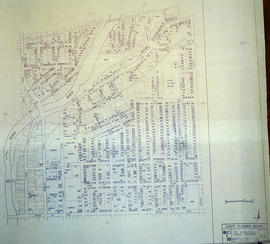
A map of the City of Belleville, including property boundaries, waterways and roads. House numbers are also included. From Bridge Street East north to Station Street and from the Moira River east to Bleecker Avenue. Map composed by the Quinte Planning Board and dated February 23, 1976. Scale 1:2400.
Donated by the Heritage Belleville Committee in 2017.