Minutes and accounts for S. S. 4, Thurlow
- CA ON00156 2010-50
- Item
- 1921-1947
Minutes and accounts for School Section number 4 in Thurlow Township, Ontario.
Thurlow Township, School Section 4
185 results with digital objects Show results with digital objects
Minutes and accounts for S. S. 4, Thurlow
Minutes and accounts for School Section number 4 in Thurlow Township, Ontario.
Thurlow Township, School Section 4
Minute and account book of Thurlow School Section #4
Volume of minutes and accounts for School Section 4 in Thurlow Township, Hastings County, Ontario.
Register of marriage licences issued in Thurlow Township
Register of marriage licences issued between 21 March 1922 and 25 December 1926. There are two later entries, in pencil, for 10 February 1942 and 8 March 1946. In total there are 34 entries in this register.
Township of Thurlow
Various notes and legal documents relating to Russell and Thomas Pitman of Thurlow Township, Hastings County. Partially transcribed by Lois Foster.
Pitman, Thomas
Cannifton-Corbyville School collection
Materials relating to Cannifton-Corbyville and other schools in Thurlow Township, Hastings County, Ontario:
Demczyna, Louise

Survey plans transferred from City of Belleville Engineering Department
A series of 506 land registry survey plans for various parcels of land in Thurlow Township.
Thurlow Junior Farmers and Junior Institute minute book
Minutes of the Thurlow Junior Farmers and Junior Institute for young women on the fifth concession of Thurlow Township in Hastings County, Ontario.
Thurlow Junior Farmers and Junior Institute
Materials collected by Mary Lu Toms:
Toms, Mary Lu
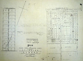
Plan of Park and Village Lots in Stirling
Part of Map collection
A certified reproduction of the "Plan of Park and Village Lots in Village of Stirling. Being Lot # 23 in 9th Concession of Sidney Township for James Ross." Surveyed by John J. Haslett, P.L.S. in 1852.
This copy was made in 1972 of plan #16A, as registered in the Hastings Land Registry Office.
Donated by Walter I. Watson, O.L.S.
Haslett, John James, P.L.S. & D.P.S.
Forestry in the Townships of Hastings and Prince Edward Counties
Part of Map collection
Forestry maps of Ameliasburgh, Murray, Rawdon, Sidney and Thurlow townships from 1980.

Map of District of Prince Edward County
Part of Map collection
Map showing townships in the District of Prince Edward County: South Murray, Sidney, Thurlow, Ameliasburgh, Sophiasburgh. See boundary lines on map. Surveyed by Publius Virgillius Elmore, D.L.S. Dated 1835. Map copied from the Archives of Ontario.
Elmore, Publius Virgillius, D.P.S.

Plan of Hastings for Hastings Directory
Part of Map collection
A map of Hastings County outlining townships:
Marmora, Lake, Madoc, Tudor, Grimsthorpe, Elzevir; Rawdon, Huntingdon, Hungerford, Sidney, Thurlow, Tyendinaga - as well as the northern townships.
Inset is "the Village of Marmora." Surveyed by H. A. F. Macleod, C.E. and P.L.S. Published by W. A. Little Lith., Montreal in the 1864-1865 copy of the Hastings Directory . Scale: 1:190,000.
MacLeod, Henry Augustine Fitzgerald, P.L.S.

Map of Hastings with the Principal Villages and the City of Belleville
Part of Map collection
A map of Hastings County including the Town of Belleville and other principal villages:
Trenton, Madoc, Marmora, Tweed, Bridgewater, Stirling, Wicklow, Bangor, Herschel, Monteagle, Carl, Dungannon, Wollaston, Limerick, Cashel, Tudor, Grimsthorpe, Elzevir; Rawdon, Huntingdon, Hungerford, Sidney, Thurlow, Tyendinaga.
Scale: 3 miles =1 inch. Published by Evans & Bolger, P. L. Surveyors, P.L.S. in 1879-1880.
Evans and Bolger

Map of Hastings County in 4 sections
Part of Map collection
A map of Hastings County outlining townships from the Bay of Quinte in the south, to Wallaston, Limerick and Cashel in the north.
Map is in four sections. Scale: 3 miles : 1 inch. Original map is dated 1894. Photocopy from the Archives of Ontario.

Map of the Counties of Hastings and Prince Edward
Part of Map collection
A "Map of the Counties of Hastings and Prince Edward." In 1898, the lots, concessions, churches, schools and mines are shown of the townships in Hastings and Prince Edward. Scale: 1.5 miles to an inch. Published by the Canadian Map Publishing Company in Hamilton, Ontario, for the Belleville Sun. Revised by Henry Carre, C.E. Inset is the map of North Hastings, scale 400 chains to an inch.
Carre, Henry, O.L.S.

Map of Hastings with townships
Part of Map collection
A map of Hastings County outlining the twelve townships:
Marmora and Lake, Madoc, Tudor, Grimsthorpe, Elzevir; Rawdon, Huntingdon, Hungerford, Sidney, Thurlow, Tyendinaga.
As well as, the lots and concessions. Circa 1916.Scale: 4 miles: 1 inch.
Donated by K.G.M. Ross.

Townships of Hastings County with advertisements
Part of Map collection
A map of Hastings County, in 1932, showing lakes, rivers, cities, towns and townships. A list of businesses within the county are on the right. Drawn exclusively for and published by Croydon Publishing Company.
Croydon Publishing Co.

Map of Southern Hastings County
Part of Map collection
Southern Hastings County in 1963. Map features boundaries, roads and railways. Scale: 1:63,360. Published by the Department of Highways, Ontario. Made by Hunting Survey Corp. Ltd. Dimensions 107.5cm x 92.5cm.
A unique "one-inch" map because all one-inch series maps were converted to 1:50,000 after 1950. However, this map was converted to 1:63,360.
Ontario. Department of Highways

Resources Map of Hastings County
Part of Map collection
Resources map of Hastings County, Ontario, showing agricultural activity and natural resources.

Lloyd's Map of Hastings County
Part of Map collection
A map of Hastings County outlining the twelve townships:
Marmora and Lake, Madoc, Tudor, Grimsthorpe, Elzevir; Rawdon, Huntingdon, Hungerford, Sidney, Thurlow, Tyendinaga. The northern townships are pictured on the right side.
As well as, the lots and concessions. Circa 1922. Scale: 1.5 miles: 1 inch. Published by Lloyd's Maps, Map Publisher.
Lloyd's Map, Map Publisher