
- CA ON00156 TR/1954
- Unidad documental compuesta
- 1935-1967
File contains newspaper articles concerning legends surrounding Meyers' and Bleecker's Cave in Hastings County.
File contains newspaper articles concerning legends surrounding Meyers' and Bleecker's Cave in Hastings County.

Field Notes of the Township of Faraday
Photocopied cover of manuscript field notes by Quintin Johnston, Provincial Land Surveyor concerning resources and quality of land in Faraday Township in 1857. Published by Ontario Department of Crown Lands.
Sin título

Aerial View of Belleville Harbour
Parte deMap collection
A reproduction of an aerial view photograph of the Belleville Harbour at the mouth of the Moira River in Belleville, Ontario. The photograph includes oil tanks, coal piles and trains. Circa 1933.
Donated by Bruce Polmanter.

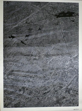
Parte deMap collection
A reproduction of an air survey photograph produced by the Ontario Ministry of Natural Resources. Map #446773W of Lake Township in Hastings County, Ontario. Circa 1950.
The photograph shows Concession 6 to 9 from the border with Marmora Township, north to Little Burnt Lake and Big Burnt Lake and Carson Lake.
Donated by Walter I. Watson, P.L.S.
Sin título
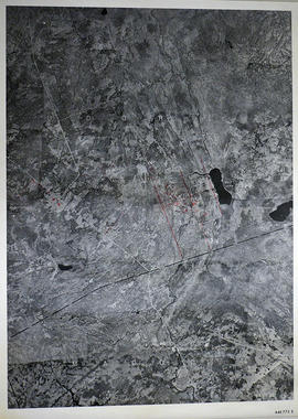
Parte deMap collection
A reproduction of an air survey photograph produced by the Ontario Ministry of Natural Resources. Map #446773E of Madoc Township in Hastings County, Ontario. Circa 1950.
The photograph shows the northern part of Madoc Township, Bannockburn, Tudor Township, Concession 1 to 9, Robinson Lake, Westerly to Millbridge, Moira River, Highway 62, and the Canadian National Railway.
Donated by Walter I. Watson, P.L.S.
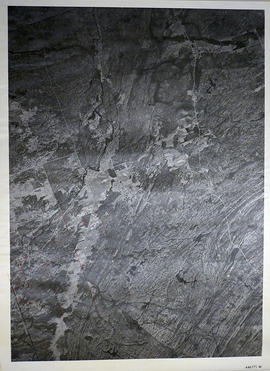
Sin título

Elzevir Township Map # 446772W
Parte deMap collection
A reproduction of an air survey photograph produced by the Ontario Ministry of Natural Resources. Map #446772W of Elzevir Township in Hastings County, Ontario. Circa 1950.
The photograph shows the Black River Watershed, North West Elzevir Township, North East Madoc Township, South West Grimsthorpe Township, South East corner of Tudor Township.
Donated by Walter I. Watson, P.L.S.
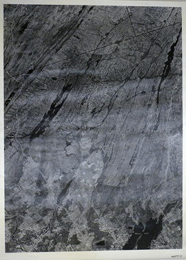
Sin título
Elzevir Township Map # 446772E
Parte deMap collection
A reproduction of an air survey photograph produced by the Ontario Ministry of Natural Resources. Map #446772E of Elzevir Township in Hastings County, Ontario. Circa 1950.
The photograph shows the North East part of Elzevir Township, Elzevir Creek and the Skootamata River.
Donated by Walter I. Watson, P.L.S.
Sin título
Kaladar Township Map # 446771W
Parte deMap collection
A reproduction of an air survey photograph produced by the Ontario Ministry of Natural Resources. Map #446771W of Kaladar Township in Lennox and Addington County, Ontario. Circa 1950.
The photograph shows Kaladar Township, Concession 1 to 7, Hwy 41, Northbrook and west to Flinton, the Skootamata River and the border of Anglesea Township.
Donated by Walter I. Watson, P.L.S.
Sin título

Kennebec Township Map # 446771E
Parte deMap collection
A reproduction of an air survey photograph produced by the Ontario Ministry of Natural Resources. Map #446771E of Kennebec Township in Frontenac County, Ontario. Circa 1950.
The photograph shows Kennebec Township, Concession 1 to 5 and south to Cranberry Lake.
Donated by Walter I. Watson, P.L.S.
Sin título

Marmora Township Map # 445773W
Parte deMap collection
A reproduction of an air survey photograph produced by the Ontario Ministry of Natural Resources. Map #445773W of Marmora Township in Hastings County, Ontario. Circa 1950.
The photograph shows Marmora Township, Crow Lake, and north to Thompson Lake.
Donated by Walter I. Watson, P.L.S.
Sin título

Parte deMap collection
A reproduction of an air survey photograph produced by the Ontario Ministry of Natural Resources. Map #445772W of Madoc Township in Hastings County, Ontario. Circa 1950.
The photograph shows Madoc Township, Concession 5 to 9, Huntingdon Township Concession 14, northwest Elzevir Township, Queenboro and Black River.
Donated by Walter I. Watson, P.L.S.
Sin título

Parte deMap collection
A reproduction of an air survey photograph produced by the Ontario Ministry of Natural Resources. Map #445773E of Madoc Township in Hastings County, Ontario. Circa 1950.
The photograph shows Madoc Township, Concession 1 to 7, Hwy 62, and Moira River Watershed, Eldorado, Lake Township, Concession 3 to 10.
Donated by Walter I. Watson, P.L.S.
Sin título

Hungerford Township Map # 445772E
Parte deMap collection
A reproduction of an air survey photograph produced by the Ontario Ministry of Natural Resources. Map #445772E of Hungerford Township in Hastings County, Ontario. Circa 1950.
The photograph shows the northeast part of Hungerford Township, south of Elzevir Township, Hwy 7 and Skootamata River.
Donated by Walter I. Watson, P.L.S.
Sin título

Hungerford Township Map # 445772W
Parte deMap collection
A reproduction of an air survey photograph produced by the Ontario Ministry of Natural Resources. Map #445772W of Hungerford Township in Hastings County, Ontario. Circa 1950.
The photograph shows the east part of Hungerford, southeast corner of Elzevir, west part of Sheffield and southwest part of Kaladar Townships in Lennox and Addington County.
Donated by Walter I. Watson, P.L.S.
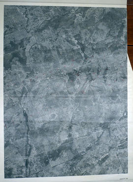
Sin título
Sheffield Township Map # 445771E
Parte deMap collection
A reproduction of an air survey photograph produced by the Ontario Ministry of Natural Resources. Map #445771E of Sheffield Township in Lennox and Addington County, Ontario. Circa 1950.
The photograph shows Sheffield Township, Concession 3 to 9, Beaver Lake and north to Kaladar Township, Concession VIII to XI, Lingham Lakes in Grimthorpe Township in Hastings County.
Donated by Walter I. Watson, P.L.S.
Sin título

Parte deMap collection
A reproduction of an air survey photograph produced by the Ontario Ministry of Natural Resources. Map # 444773W of Rawdon Township in Hastings County, Ontario. Circa 1950.
The photograph shows Rawdon Township, Concession 8 to 14, west of Hwy 14, small sections of Marmora Township including Marmora Village and Crow Lake and a small part of Seymour Township in Northumberland County
Donated by Walter I. Watson, P.L.S.
Sin título

Parte deMap collection
A reproduction of an air survey photograph produced by the Ontario Ministry of Natural Resources. Map # 444773E of Rawdon Township in Hastings County, Ontario. Circa 1950.
The photograph shows Rawdon Township from the eastern border to Hwy 14, Harold and Springbrook Villages, western Huntingdon Township, southern Marmora and Madoc Townships, Banker Lake.
Donated by Walter I. Watson, P.L.S.
Sin título

Huntingdon Township Map # 444772W
Parte deMap collection
A reproduction of an air survey photograph produced by the Ontario Ministry of Natural Resources. Map # 444772W of Huntingdon Township in Hastings County, Ontario. Circa 1950.
The photograph shows Huntingdon Township, Fuller Village north to Concession 13 and Moira Lake.
Donated by Walter I. Watson, P.L.S.
Sin título

Hungerford Township Map # 444772E
Parte deMap collection
A reproduction of an air survey photograph produced by the Ontario Ministry of Natural Resources. Map #444772E of Hungerford Township in Hastings County, Ontario. Circa 1950.
The photograph shows Hungerford Township, Concession 3 to Tweed Village, Stoco Lake and Bogart Village.
Donated by Walter I. Watson, P.L.S.
Sin título
Hungerford Township Map # 444771W
Parte deMap collection
A reproduction of an air survey photograph produced by the Ontario Ministry of Natural Resources. Map # 444771W of Hungerford Township in Hastings County, Ontario. Circa 1950.
The photograph shows Hungerford Township from Tyedinaga Township north to Bogart and Claire River.
Donated by Walter I. Watson, P.L.S.
Sin título