
- CA ON00156 M/M420-1093/Marmora
- Part
- 1898
Part of Map collection
2408 results with digital objects Show results with digital objects
Part of Map collection

Electoral Map of the Province of Ontario
Part of Map collection
An Electoral Map of the Province of Ontario, including all of the electoral districts outlined in red. Composed by Surveyor General F. W. Beatty. Published by the Ontario Department of Lands & Forests in 1955. Scale 8 miles to an inch.
Donated by the Argue family in 2013.
Ontario. Department of Lands and Forests

Ontario Map from the National Topographic Series
Part of Map collection
A topographical map of Ontario from the Department of Mines and Technical Surveys, Surveys and Mapping Branch. Area includes west Lake Superior, east Quebec, north James Bay and south to Lake Erie. Dated April 30, 1956. Scale 1:63,360.
Canada. Department of Mines and Technical Surveys
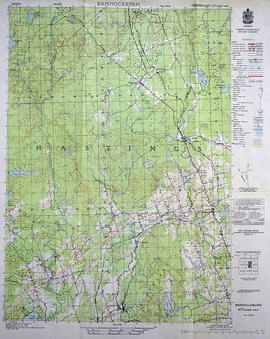
Topographical Map of Bannockburn - east half
Part of Map collection
A topographical map of Bannockburn - Canada sheet #31 C/12 (east half). Area includes Little Burnt Lake in the north, Crowe Lake and Deloro in the south. From Thompson Lake in the west to Bannockburn in the east. Map was published by the Department of National Defence in 1950. Scale 1:50,000.
Canada. Department of National Defence

Topographical Map of Tweed - Canada sheet
Part of Map collection
A topographical map of Tweed - Canada sheet #31 C/6 (east half). Area extends from west Blessington to east of the Salmon River and north to Bogart and south to Lonsdale. Map was published by the Department of National Defence in 1950. Scale 1:50,000.
Canada. Department of National Defence

Topographical Map of Belleville - Canada sheet
Part of Map collection
A topographical map of Belleville - Canada sheet #31 C/3 (west half). Area extends from North-Honeywell corner to South-Conscecon Lake and from East- Hungry Bay to West [racist slur redacted] Narrows. Map was published by the Department of National Defence in 1950. Scale 1:50,000.
Canada. Department of National Defence

Aerial View of Belleville Harbour
Part of Map collection
A reproduction of an aerial view photograph of the Belleville Harbour at the mouth of the Moira River in Belleville, Ontario. The photograph includes oil tanks, coal piles and trains. Circa 1933.
Donated by Bruce Polmanter.

Part of Map collection
A Soil Map of Hastings County Ontario, South Sheet, Soil Survey Report # 27. Published by the Experimental Farms Service of Ottawa. in 1958. Base maps supplied by the Department of Mines and Technical Surveys. Soil survey by the Department of Soils, Ontario Agricultural College, Guelph and the Experimental Farms Service, Canada Department of Agriculture, Ottawa. Scale 1 inch to 1 mile.
Canada. Department of Agriculture

Topographical Map of Kingston - Canada sheet
Part of Map collection
A topographical map of the area, in Canada and the USA, surrounding Kingston. The total area extends from Norwood (west) to Smith Falls (east) and Buckshot Lake (north) to Picton (south). Dated 1958-1959. Published by the Army Survey Establishment.
Donated by the Belleville Public Library in 2014.
Army Survey Establishment

Topographical Map of Belleville - Canada sheet - east half
Part of Map collection
A topographical map of Belleville - Canada sheet #31 C/3 (east half). Area extends from North-Milltown/Marysville to South-Picton and from East-Lennox and Addington to Salmon River and Big Island. Map was published by the Department of National Defence, Army Survey Establishment in 1950. Scale 1:50,000.
Donated by the Belleville Public Library in 2014.
Army Survey Establishment

Topographic Map of Ontario - Belleville Sheet
Part of Map collection
A map from the Eastern Canada series entitled "Topographic Map of Ontario - Belleville Sheet 31 C/3." The map includes Hastings County to Hillier in Prince Edward County. Published in 1938 by the Department of National Defence. Scale 1 inch to 1 mile.
Donated by the Belleville Public Library in 2014.
Canada. Department of National Defence
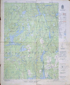
Topographical Map of Bannockburn - west half
Part of Map collection
A topographical map of Bannockburn - Canada sheet #31 C/12, west half. Map was published by the Department of National Defence in 1950. Scale 1:50,000.
Donated by Eric Jones.
Canada. Department of National Defence

Topographical Map of Ontario - Campbellford sheet
Part of Map collection
A topographical map of Ontario - Campbellford sheet #31 C/5. Map was published by the Department of National Defence and reprinted in 1941. Scale 1:63,360.
Donated by Eric Jones.
Canada. Department of National Defence

Topographical Map of the Belleville to Kingston
Part of Map collection
A topographical map of the area between Belleville and Kingston. The total area extends from Prince Edward County to Buckshoot Lake North & South and from Havelock to Smith Falls East and West. Dated 1935. Published by the Department of National Defense.
Donated by Eric Jones.
Canada. Department of National Defence

Topographical Map of west Trenton - Canada sheet
Part of Map collection
A topographical map of west Trenton - Canada sheet #31 C/4. Area includes the West Half of Trenton and part of Northumberland County. Map was published by the Department of National Defence in December 1962. Scale 1:50,000.
Canada. Department of National Defence

Topographical Map of Ontario - Belleville Sheet
Part of Map collection
A map of Hastings, Prince Edward, Northumberland and Peterborough counties in 1929 from the Department of Interior Canada. By J.E. Chalifour, Chief Geographer. Scale: 1" to 3.95 miles.
The legend includes additional information about counties, towns, villages, boundaries, railways, canals, lots, concessions, portages, rapids and First Nations Territories.
Canada. Department of the Interior

Topographical Map of west Belleville - Canada sheet
Part of Map collection
A topographical map of west Belleville - Canada sheet #31 C/3. Area includes the West Half of Belleville and Part of Prince Edward County. Map was published by the Department of National Defence in 1962. Scale 1:50,000.
Canada. Department of National Defence

Topographical Map of east Belleville - Canada sheet
Part of Map collection
A topographical map of east Belleville - Canada sheet #31 C/3. Area extends from Tyendinaga Mohawk Territory to Lennox & Addington East to West and South to Picton Bay. Map was published by the Department of National Defence in November 1962. Scale 1:50,000.
Canada. Department of National Defence

Reproduction of a topographical Map of the New Welland Canal
Part of Map collection
A reproduction of a topographical map showing the New Welland Canal and the country lying between Allanburgh and Port Dalhousie, by Thomas Monro and John Page (Chief Engineers of Canals). The Welland Canal shows the extent of communities along the canal, government lands along the canal and private owners of lands. The information on the map is from surveys completed in 1870-1871. Scale: 5 feet to an inch.
This map was published by Stonehouse Productions as part of "Charting Our Past" from the Archives of Ontario.
Monro, Thomas

Canada Mines and Technical Surveys
Part of Map collection
"Canada Mines and Technical Surveys" covering area in Ontario and Southwestern Quebec. Published 1954. Scale: 50 miles to 1 inch.
Canada. Department of Energy, Mines and Resources