File contains a newspaper article concerning an early Sulpician mission to the Cayuga First Nation in the Quinte region ca. 1668, and missionization by the Jesuits and Sulpicians among the Wendat(Huron), Mohawk and Oneida in what is now Quebec.
File contains a photocopy of the front page of “The Justice of the Peace, and Parish Officer” by Richard Burn, LL.D., 16th Edition, Four Volumes, printed London 1788. Two of the four volumes are in the Law Library of the Hastings Law Society.
A 1719 map of Canada (New France) covering the explored areas of Canada previously featured on Guillaume de l'Isle's former map of 1703. Reproduction published by Stonehouse Publications in St. Catharines, Ontario.
Map showing "The 5 Big Lakes of Canada" by Jacques Nicholas Bellin, Paris, 1764. Bellin produced a maritime atlas containing this map, showing the topography, forts, portages and the Mission Ste. Marie in the Great Lakes area. This map was published by Stonehouse Productions as part of "Charting Our Past" from the Archives of Ontario.
A survey plan map of the Township of Fredericksburg, 1784. Contains names of local property owners and bodies of water. Composed by James Peachy, Lewis Kotte, Henry Holland and Samuel Jaffe. Scale: 40 chains in an inch. Dimensions: 53cm x 39cm.
Map showing the Bay of Quinte to Presqu'ile to the eastern tip of Grande Isle (Wolfe Island) used as a teacher's guide to the area in 1785. The 20th century names are in capital letters as per the Legend.
A copy of an original map by Surveyor General John Collins showing land from Presqu'ile to Kingston in 1785. Scale: 4 miles : 1 inch. Photocopied by the Archives of Canada 10 Jan 1990.
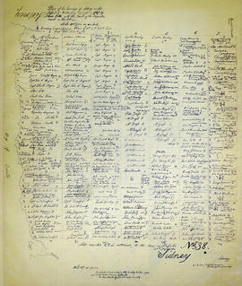
A recopy of the 1787 map of Sidney Township. The original map entitled "Plan of the Township of Sidney in the District of Mecklinburg. Surveyed in 1787 by Lewis Kotts, with the names of the proprietor inserted in the Lots." The recopy was completed by Mrs. Dorothy Ashton in 1981, for the Corby Public Library and Hastings County Historical Society. Scale 40 chains to an inch.
A map of the Township of Thurlow, in 1787. Contains names of local property owners within their respective lots. Surveyed by Deputy Provincial Surveyor Lewis Kotte. Scale: 40 chains : 1 inch.
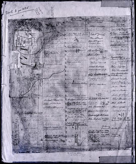
A map of Sidney Township, specifically the District of Mecklenburg in 1787. Contains information on the plans for the 1st, 2nd, and 3rd concessions, as well as property owners. Created by Lewis Kotte, Deputy Provincial Surveyor. Scale: 40 chains to an inch.
A land grant map of the Township of Thurlow, in 1787. Contains names of local property owners within their respective lots and concessions 1-4. Footnotes around the waterfront were added c.1960. Dimensions: 22cm x 28cm.
This file contains a copy of a c.1788 Upper Canada Proclamation, made by Geo. Pownall. Mentioning; “The Bay of Quinty”and also with references the Trent River, Sidney Township.
Map showing townships by the waterfront of the Bay of Quinte and the Mohawk Territory. This area encompasses townships in both Prince Edward and Hastings Counties. Text on map says "District of Nassau." Dated 1790. Map copied from the Archives of Ontario.
File contains photocopies of field notes dated 1791-92 of a survey of the Indian Lands on Grand River; the course of the Lake Ontario from Toronto to the River Trent; Head of the Bay of Quinty (sic). Donated by K.G.M. Ross
File contains a photocopied manuscript petition to Lt. Governor John Graves Simcoe by Captain John W. Meyers for the grant of lot no. 4 in Thurlow Township for the use and improvement by the Meyers family.
File contains a reproduction of a manuscript diary of W. Hambly, surveyor, for the period 6 December 1793 to 1 May 1794. The diary entries discuss the survey process in Thurlow, Sidney, Huntingdon and Rawdon Townships. Also present is a typescript transcript of the diary with an appended footnote section which contains a glossary of terms.
Reproduction of a map showing "the Routes Lt. Gov. J. G. Simcoe took on trips" throughout Upper Canada from March 1792 to September 1795. The map was charted by Lt. Gov. Simcoe. A good depiction of the area now referred to as Southern Ontario and his plans for a capital there - "London." This map was published as part of "Charting Our Past" from the Archives of Ontario by Stonehouse Publications.