A map of the Buildings Designated under the Ontario Heritage Act in Belleville, Ontario. Created by the Heritage Belleville Committee on November 22, 1985 and revised February 14, 1994. The area includes; the Bay of Quinte north to Highway 401 with designations in the area between Sidney Street and McDonald Avenue.
A topographical map of Campbellford - sheet #31 C/5. Includes Crowe Lake, south Trent River, west Asphodel Township & rast Oak Lake. Composed by the Department of Natural Resources. Published by Canadian Topographic Maps in 1994. Scale 1:50,000.
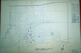
A map of the Downtown Area of the City of Belleville including building outlines and street addresses. The map covers Church Street east to Foster Ave and Edmund Street north to Pine St.
A map describing areas of land ownership and fish species in Bancroft/Mazinaw. The map covers the following townships: Hastings County: Lake, Tudor & Grimsthorpe Lennox and Addington County: Ashby, Denbigh, Effingham, Abinger & Anglesea Frontenac County: Barrie, Clarendon, Miller, North Canonto, South Canonto, & Palmerston
Scale 1cm:1km. Published by the Ontario Ministry of Natural Resources in 1993.
Ontario. Ministry of Natural Resources and Forestry
A map of Ontario to eastern Quebec entitled "Surveyed for Settlement." Produced to commemorate the organization's centennial 1892-1992. Pictures and stories of early surveying surround the map. Scale 1:2,775,000.
A topographical map of Ontario from the Canada Index 1, Maps of the National Topographic System of Canada. Published by the Department of Mines and Resources (now the Department of Natural Resources). Dated July 1991. Scale 1:50,000.
A topographical map of Tweed - Canada sheet #31 C/6, 7th edition. Map published by the Department of Energy, Mines and Resources, Canada in 1991. Scale 1:50,000.
Key to Zoning By-law Maps of the City of Belleville. Scale: 1:4800. Published by the Quinte Planning Board. 1) M440-1328. Dated 6 Nov 1976. Revised 2 Apr 1991. 2) M440-1329. Dated 6 Nov 1976. Revised 6 Jun 1991. 3) M440-1330. Dated 6 Nov 1976. Revised 19 Aug 1991. 4) M440-1331. Dated 6 Nov 1976. Revised 28 May 1991. 5) M440-1332. Dated 10 Oct 1990. 6) M440-1333. Dated 16 Dec 1985. Revised 21 Feb 1990. 7) M440-1334. Dated 19 Dec 1985. Revised
A topographical map of Belleville - Canada sheet #31 C/3. Map was published by the Department Energy, Mines and Resources Canada in 1991. Scale 1:50,000.
A map featuring the towns, cities and major tourist attractions from Belleville to Brockville. Sponsored by Rideau Marina Kingston Ltd, Atlantis Direct Marketing Inc., and CKWS television. On the reverse - brief explanations of the major cities/towns.
Schedule plans A - F for the City of Belleville. Researched by the Quinte Planning Board. Published by Totten Sims Hubick; Associates Limited. All maps must be read in conjunction with the associative text provided. 1) M440-1344. Dated Jul 1988. Schedule A - Planning Districts and Planning Units. Scale 0-1000:4". 2) M440-1345. Dated Aug 1974. Revised Jan and Oct 1975. Schedule B - Land Use Plan. Scale 1" : 800ft. 3) M440-1346. Dated Aug 1974. Revised Jan and Oct 1975. Schedule C - Recreation Plan. Scale 1: 9600. 4) M440-1347. Dated Aug 1974. Revised Jan and Oct 1975. Schedule D - Residential Density Plan. Scale 1: 9600. 5) M440-1348. Dated Aug 1974. Revised Jan and Oct 1975 and Sep 1986. Schedule E - Transportation Plan. Scale 1: 9600. 6) M440-1349. Dated 1990. Schedule F - Municipal Services Plan. Scale 1: 9600.
An aerial photograph of the Lower Trent Region Conservation Authority, Sheet LTR1-286 of 374. Published by Kenting Earth Sciences. Aerial photography by Airborne Sensing Corporation. Scale: 1;5000.