A part of a research project studying the evolution of wards in Belleville, from 1836 - 1874. The wards are coloured in on Charles Mott's map of the City of Belleville (circa 1950).
A topographical map of Trenton - sheet #31 C/4. Includes north Murray Marsh, south Presqu'ile & Lake Ontario, west Carmel and east Bayside. Composed by the Department of Natural Resources. Published by Canadian Topographic Maps in 2000. Scale 1:50,000.
A photocopy of a map detailing Grand Trunk and Grand Junction Railways trackage and the history of it, at Belleville, Hastings County, Ontario. The map indicates the “Cross Over Diamond” Grand Junction Railway over Grand Trunk: approx November 1877, removed approx. August 1883. Researched and drawn by David L. Pershick - November 12, 1999.
A double-sided map of the accommodations, camping and attractions located in Land O' Lakes. Includes North & West of Kingston including Napanee, the Frontenacs, Loyalist Country & Mazinaw Country. Advertisements surround the map. Dated 1999.
Plans for a Proposed Hastings Heritage Centre in former Thurlow Township Municipal Hall and Offices, located at 154 Cannifton Rd. North. By Gerry Boyce, Susie Boyce, Carson Cross. The former Historical Society and Archives until 2016.
A full color Map Guide to Belleville & Trenton. Published by Citi Design Group Inc. in 1997. Using a numerical/alpha grid system, different advertisers throughout the city are named and located with cartoon images. On the back is the full name of the business and grid location.
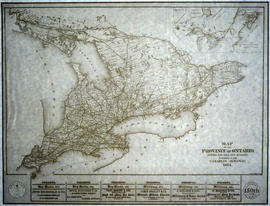
A reproduction of a "Map of the Province of Ontario Showing Railways now Running." A series of Toronto business advertisements line the bottom of the map. Originally published by the Canadian Almanac in 1884. Reproduced by COPP Clark Professional in January 1997 for the celebration of 150 continuous years of almanac and directory publishing.
A map of all of Canada and the boreal forest included within. Additional environmental information can be found on the borders. Composed by the Canadian Department of Natural Resources. Published by Canadian Geographic in 1996.
A by-law map for the City of Belleville covering area from the Bay of Quinte to College Street & the Moira River to Sidney Street. Initially dated April 4, 1977 but revised later on October 2, 1996. Complied by the Quinte Planning Board. Scale 1;4800. Signed by Mayor J. Ben Corke and Clerk Earl M. Dafoe.
A by-law map for the City of Belleville covering area from the Bay of Quinte to College Street & Station Street, Herchimer Avenue to the Moira River. Initially dated April 4, 1977 but revised later on October 2, 1996. Complied by the Quinte Planning Board. Scale 1;4800. Signed by Mayor J. Ben Corke and Clerk Earl M. Dafoe.
A topographical map of Whitney - sheet #31 E/8. Includes Caleairy Lake, south Big Mink Lake, west Lake Louisa, and east McKenzie Lake. Composed by the Department of Natural Resources. Published by Canadian Topographic Maps in 1996. Scale 1:50,000.
A Regional Map of Belleville, Trenton, Sidney Township and Picton. Including advertisements around map. Composed by the Belleville & District Chamber of Commerce. Published by the Ontario Mapping Company in 1995.
A research project completed by the Heritage Belleville Committee from October 1993 - February 1994. The project researched designated (red) and non-designated (blue) heritage properties in the West Hill area of Belleville, Ontario.