Showing 813 results

Archival description
Item Land, settlement and immigration Image
Print preview Hierarchy View:

813 results with digital objects Show results with digital objects

Research Project of the Wards in Belleville

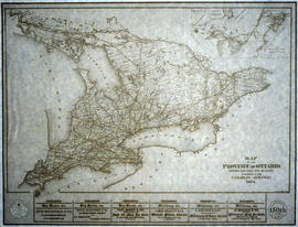
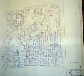
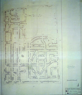
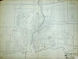
A part of a research project studying the evolution of wards in Belleville, from 1836 - 1874. The wards are coloured in on Charles Mott's map of the City of Belleville (circa 1950).

Donated by the Belleville Public Library in 2014.

Belleville Public Library

Copy of a Map of the Province of Ontario showing Railways

A reproduction of a "Map of the Province of Ontario Showing Railways now Running." A series of Toronto business advertisements line the bottom of the map. Originally published by the Canadian Almanac in 1884. Reproduced by COPP Clark Professional in January 1997 for the celebration of 150 continuous years of almanac and directory publishing.

Donated by the Belleville Public Library in 2014.

Copp Clark Limited

By-law Map #3 of the City of Bellleville

  • CA ON00156 M/M450-3052
  • Item
  • 4 Apr 1977 - 2 Oct 1996
  • Part of Map collection

A by-law map for the City of Belleville covering area from the Bay of Quinte to College Street & the Moira River to Sidney Street. Initially dated April 4, 1977 but revised later on October 2, 1996. Complied by the Quinte Planning Board. Scale 1;4800. Signed by Mayor J. Ben Corke and Clerk Earl M. Dafoe.

Donated by Lois Foster.

Quinte Planning Board

By-law Map #4 of the City of Bellleville

  • CA ON00156 M/M450-3053
  • Item
  • 4 Apr 1977 - 2 Oct 1996
  • Part of Map collection

A by-law map for the City of Belleville covering area from the Bay of Quinte to College Street & Station Street, Herchimer Avenue to the Moira River. Initially dated April 4, 1977 but revised later on October 2, 1996. Complied by the Quinte Planning Board. Scale 1;4800. Signed by Mayor J. Ben Corke and Clerk Earl M. Dafoe.

Donated by Lois Foster.

Quinte Planning Board

City of Belleville Map with Property Boundaries in 1981

A map of the City of Belleville, including property boundaries, waterways and roads. From the Moira River in the east to the Bay of Quinte south and CNR & North Front Street in the north to Avondale Road in the west. Map composed by the Quinte Planning Board and dated October 1, 1981. Scale 1:4800.

Donated by the Heritage Belleville Committee in 2017.

Quinte Planning Board

Central City of Belleville Map with Property Boundaries in 1976

A map of the City of Belleville, including property boundaries, waterways and roads. House numbers are also included. From Bridge Street East north to Station Street and from the Moira River east to Bleecker Avenue. Map composed by the Quinte Planning Board and dated February 23, 1976. Scale 1:2400.

Donated by the Heritage Belleville Committee in 2017.

Quinte Planning Board

South City of Belleville Map with Property Boundaries in 1976

A map of the City of Belleville, including property boundaries, waterways and roads. House numbers are also included. From Bay of Quinte north to Bridge Street East and from the Moira River east to Foster Avenue. Map composed by the Quinte Planning Board and dated February 23, 1976. Scale 1:2400.

Donated by the Heritage Belleville Committee in 2017.

Quinte Planning Board

East City of Belleville Map with Property Boundaries in 1976

A map of the City of Belleville, including property boundaries, waterways and roads. House numbers are also included. From Bridge Street East north to Station Street and from the Bleecker Avenue east to Herchimer Avenue. Map composed by the Quinte Planning Board and dated February 23, 1976. Scale 1:2400.

Donated by the Heritage Belleville Committee in 2017.

Quinte Planning Board

Street Plan of the City of Belleville 1975

  • CA ON00156 M/M440-2564
  • Item
  • 6 Feb 1974 - 2 Nov 1975
  • Part of Map collection

A map detailing local streets, schools and their respective names, in Belleville, Ontario. Composed by the Quinte Planning Board in February 1974. Revised November 2, 1975.

Donated by the Belleville Public Library in 2014.

Quinte Planning Board

Registrar's Plan of Lot 12 in Sidney Township

A certified reproduction of the "Registrar”s Compiled Plan, being a graphic index of part of Lot # 12, Concession 2, Township of Sidney.” The area includes; Lots # 1 to 22 on the West side of White's Road and North between Concession 1 and 2, Township of Sidney. Surveyed by Walter I. Watson, O. L. S. and signed April 19, 1973.
Donated by Walter I. Watson, P. L. S.

Watson, Walter Irvine, O.L.S.

Subdivision of part of Lots 38-39 in the City of Belleville

A certified reproduction of the "Subdivision of part of Lots # 38 & 39. Reg. Plan No. 22, Belleville, owners Ross Robinson & Elizabeth Robinson.” The area includes; Lots # 1, 2, 3, Blocks A & B regarding widening at South East corner of Tracey St. and Lemoine Street. Surveyed by Walter I. Watson, O. L. S. and signed March 29, 1973.

Donated by Walter I. Watson, P. L. S.

Watson, Walter Irvine, O.L.S.

Subdivision of part of Lot 13 in the Township of Thurlow

A certified reproduction of the "Subdivision of part of Lot # 13, Concession 1, Township of Thurlow, Belleville.” The area includes; Lot # 1 to 11, and Block “A” South of Bridge Street East and West of Haig Road. Surveyed by Walter I. Watson, O. L. S. and signed October 18, 1973.

Donated by Walter I. Watson, P. L. S.

Watson, Walter Irvine, O.L.S.

Subdivision of Block A in the City of Belleville

A certified reproduction of the "Subdivision of Block A, Reg. Plan No. 1904, Belleville, owner Maurice H. Rollins.” The area includes; Lots # 1 to 14, Blocks A and B and Conger Place North of College Street West ( the third street west of Sidney Street). Surveyed by Walter I. Watson, O. L. S. and signed May 10, 1972.

Donated by Walter I. Watson, P. L. S.

Watson, Walter Irvine, O.L.S.

Subdivision of Lot 13 in the City of Belleville

A certified reproduction of the "Subdivision of part of the West ½ of Lot # 13, Concession 1, Township of Thurlow, now Belleville, owner Lambert-Rollins Construction Ltd.” The area includes; Block A, Lots # 1 to 41, Diamond Crescent, Flint Driver, and Haig Road. Surveyed by Walter I. Watson, O. L. S. and signed December 29, 1972.

Donated by Walter I. Watson, P. L. S.

Watson, Walter Irvine, O.L.S.

Street Plan of the City of Belleville 1972

  • CA ON00156 M/M440-2563
  • Item
  • Oct 1965 - Nov 1972
  • Part of Map collection

A map detailing local streets, schools and their respective names, in Belleville, Ontario. Composed by the Quinte Planning Board in October 1965. Revised November 1972.

Donated by the Belleville Public Library in 2014.

Quinte Planning Board

Subdivision of part of Lots 8-9 in the City of Belleville

A certified reproduction of the "Subdivision of Part of Lots # 8 & 9 East of North Park Street, Gov't Plan and part of Lot # 5, Concession 2, Township of Thurlow, now Belleville, owner J. L. Farrell Construction Ltd.” The area includes; Lots # 1 to 52, Blocks A & B, March Drive, Chown Crescent and McFee Street, being East of North Park Street.. Surveyed by Walter I. Watson, O. L. S. and signed February 17, 1972.

Donated by Walter I. Watson, P. L. S.

Watson, Walter Irvine, O.L.S.

Registrar's Plan of Lot 13 in Sidney Township

A certified reproduction of the "Registrar's compiled Plan, being a graphic index of Part of Lot # 13, Concession 2.” The area includes; Lots # 1 to 28 East of White's Road and South of Hwy 401.. Surveyed by Walter I. Watson, O. L. S. and signed November 16, 1972.

Donated by Walter I. Watson, P. L. S.

Watson, Walter Irvine, O.L.S.

Registrar's Plan of Lot 13 in Sidney Township

A certified reproduction of the "Registrar's Compiled Plan, being a graphic index of Part of Lot # 13, Concession 2, Township of Sidney.” The area includes; Lots # 1 to 75, East of White's Road and North of Meyers Creek Road, including Jeffrey Drive. Surveyed by Walter I. Watson, O. L. S. and signed November 16, 1972.

Donated by Walter I. Watson, P. L. S.

Watson, Walter Irvine, O.L.S.

Registrar's Plan of Lot 13 in Sidney Township

A certified reproduction of the "Registrar's compiled Plan, being a graphic index of Part of Lot # 13, Concession 2.” The area includes; Lots # 1 to 56 East of White's Road and County Road No. 22 (Hamilton Rd.) including Jeffrey Road. Surveyed by Walter I. Watson, O. L. S. and signed November 17, 1972.

Donated by Walter I. Watson, P. L. S.

Watson, Walter Irvine, O.L.S.

Subdivision of Lots 99-102 in the City of Belleville

A certified reproduction of the "Subdivision of Lots # 99, 100, 101, 102, Blocks D and F and part of Richmond Grove, Reg. Plan 1604...Township of Thurlow, now Belleville.” The area includes; Lots # 5, 10, 11 and part of Lots # 6, 7, 8, 9, and Richmond Grove, Easterly of Haig Road, being Lot # 13, Concession 1 Township of Thurlow. Surveyed by Walter I. Watson, O. L. S. and signed April 12, 1971.

Donated by Walter I. Watson, P. L. S.

Watson, Walter Irvine, O.L.S.

Results 1 to 20 of 813