Showing 116 results

Archival description
Transportation and utilities With digital objects
Print preview Hierarchy View:

William Michaud Railway Papers

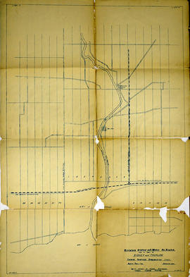
This file contains a number of newspaper articles from The Ontario Intelligencer containing pictures and history of the railways in Eastern Ontario; a number of maps showing the routes in Eastern Ontario; a brief review of the history written by R.F. Corley (March 9, 1964) and titled "Railway Development In Central Ontario".

Michaud, William

William Freeman railway photographs

  • CA ON00156 2019-015
  • Fonds
  • c.1911

Eighteen photo-postcards of Hastings County scenes, taken by William Freeman. They include images of Bannockburn (2), Eldorado (4), Moscow (1), and Trenton (3). Items donated in 2011 include a photograph of Oran Tripp at Trenton, snapshots of the Rose family of Millbridge, a Model T at Bannockburn in 1911 and three C.N.R. engines at Bannockburn in 1912.

Freeman, William

Trenton Electric & Water Co. Limited in Thurlow Township

  • CA ON00156 M/M430-2998 - 3001/M430-2998
  • Item
  • c. 1910
  • Part of Map collection

An original map produced for the Trenton Electric & Water Co. Limited, concerning their water mains, towers and substations within the Township of Thurlow. However, the map also features railways, roads and land boundaries. Circa 1910. Scale: 50 chains = 1 inch. Map composed by Smith, Kerry and Chace Engineers located in Toronto, Winnipeg, Calgary and Vancouver.

Donated by David Pershick.

Smith, Kerry and Chace Engineers

Trenton Electric & Water Co. Limited in Thurlow and Sidney Townships

  • CA ON00156 M/M430-2998 - 3001/M430-2999
  • Item
  • 31 Mar 1910
  • Part of Map collection

An original map produced for the Trenton Electric & Water Co. Limited, concerning proposed transmission lines within the Townships of Thurlow and Sidney. However, the map also features railways, roads, mills and land boundaries. Dated March 31, 1910. Scale: 1/4 mile = 1 inch. Map composed by Smith, Kerry and Chace Engineers located in Toronto, Winnipeg, Calgary and Vancouver.

The map includes the first 4 concessions, Lots 33-38 in Sidney Township and Lots 1-13 in Thurlow Township.

Donated by David Pershick.

Smith, Kerry and Chace Engineers

Trenton Electric & Water Co. Limited in Sidney Township

  • CA ON00156 M/M430-2998 - 3001/M430-3001
  • Item
  • c. 1910
  • Part of Map collection

An original map produced for the Trenton Electric & Water Co. Limited, concerning proposed transmission lines within the Township of Sidney. However, the map also features railways, roads and land boundaries. Circa 1910. Scale: 50 chains = 1 inch. Map composed by Smith, Kerry and Chace Engineers located in Toronto, Winnipeg, Calgary and Vancouver.

Donated by David Pershick.

Smith, Kerry and Chace Engineers

Townships of Hastings County with advertisements

A map of Hastings County, in 1932, showing lakes, rivers, cities, towns and townships. A list of businesses within the county are on the right. Drawn exclusively for and published by Croydon Publishing Company.

Croydon Publishing Co.

Township of Monteagle with Concessions and Railways

  • CA ON00156 M/M430-3030
  • Item
  • 30 Jul 1862 - 1906
  • Part of Map collection

A reproduction of a map of the Township of Monteagle in the County of Hastings. The map features railway lines, Concessions & Lots with the names of residents. The original map was published by the Quebec Department of Lands on July 30, 1862 and revised in 1906.

Quebec. Department of Lands

Town of Trenton with advertising businesses

A photocopy of a map of the Town of Trenton, circa 1915. The map features advertisements for local businesses, important sites, industries and many railways and stations.

Donated by Bruce Polmanter.

"Things to see and do in Ontario" Map

A map of Ontario detailing sports and activities located within the "Heart of Canada - Ontario - [an] easy to reach vacation land!" The "things to see & do" are located at different stops along the Trans-Canada Highway. Map dated 1961. Published for free distribution by the Department of Travel & Publicity of the Province of Ontario.

Ontario. Department of Travel and Publicity

The 'Monck' Road : colonization road, 1863

File contains newspaper articles concerning the history of the Monck Road, a colonization road primarily, but also intended as a less vulnerable military route between the Upper Great Lakes and the Ottawa Valley, passing near Bancroft, Ontario. The road was surveyed in 1864-1865 and named in honour of Governor-General, Lord Monck. Also included is typescript transcript of an article entitled "Was the Monck Road for Military Use?" / by Dr. J. J. Talman, first published in the Orillia Packet and Times, 27 June 1940

Slides of Belleville and Ontario scenes

  • CA ON00156 2021-041
  • Series
  • 1969-1971

Slides made by Rudolf Donninger during his time in Belleville, Ontario, working at Northern Electric. They include photographs of buildings in Belleville, rural scenes, cars, a parade and the Belleville Fair in 1970, winter scenes, Ottawa and Kingston views, and aircraft at the Trenton Air Show.

Donninger, Rudolf

Skyway Bridge

Newspaper clipping with photograph of Skyway Bridge under construction, and McNews magazine of McNamara of Canada, June 1965, with an article on the construction project.

Seymour Power & Electric Co. Limited in Murray Township

  • CA ON00156 M/M430-2998 - 3001/M430-3000
  • Item
  • c.1910
  • Part of Map collection

An original map produced for the Seymour Power & Electric Co. Limited, concerning proposed transmission lines within the Township of Murray. However, the map also features railways, roads, mills and land boundaries. Circa 1910. Scale: 50 chains = 1 inch. Map composed by Smith, Kerry and Chace Engineers located in Toronto, Winnipeg, Calgary and Vancouver.

Donated by David Pershick.

Smith, Kerry and Chace Engineers

Road Map of the Province of Ontario 1967

A road map of the northern and southern portions of the Province of Ontario. Published by the Ontario Department of Highways in 1967 for the Centennial Year. Various indexes and legends are located on the map.

Ontario. Department of Highways

Road Map of the Province of Ontario 1956

A road map of the northern and southern portions of the Province of Ontario. Published by the Ontario Department of Highways in 1956. Various indexes and legends are located on the map.

Ontario. Department of Highways

Road Map of the Province of Ontario 1953

A road map of the northern and southern portions of the Province of Ontario. Published by the Ontario Department of Highways in 1953. Various indexes and legends are located on the map.

Ontario. Department of Highways

Results 1 to 20 of 116