
- CA ON00156 TR/2901
- Item
- 1967
Parte de HCHS Textual Records collection: Files 2500 to 2999
File contains a typescript note on the status of Thurlow schools by school section, indicating the dates of their establishment and their current use.
Parte de HCHS Textual Records collection: Files 2500 to 2999
File contains a typescript note on the status of Thurlow schools by school section, indicating the dates of their establishment and their current use.

Map of Belleville by Evans & Bolger 1877
Parte de Map collection
An 1877 map of Belleville, Hastings County, Ontario by Evans & Bolger, surveyors. Map includes a table showing dates of plans in the registry office with plan name, wards and dates.

Survey plans transferred from City of Belleville Engineering Department
A series of 506 land registry survey plans for various parcels of land in Thurlow Township.

Jones, Mrs. Eliza, Deed of Land, Eliza Wife of Rev. Sept. Jones 1868
Parte de HCHS Textual Records collection: Files 1500 to 1999
File contains a Deed of Land Sale between Agnes Fitzgibbon of Toronto and Eliza Jones of lots one and two on Bridge Street in Belleville, Ontario.

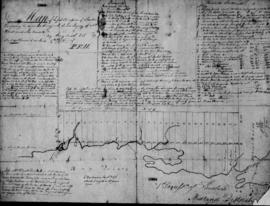
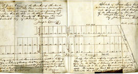
Sketch of the two front Concessions and Broken front of Thurlow
Parte de HCHS Textual Records collection: Files 2500 to 2999
A concession survey sketch of Thurlow, signed by land surveyor Henry Smith.
Map of the First Concession of Thurlow
Parte de HCHS Textual Records collection: Files 2500 to 2999
A map of the first concession of Thurlow, signed by land surveyor Henry Smith.

Hastings County Council Papers; Reports of County Surveyors 1855
Parte de HCHS Textual Records collection: Files 1000 to 1499
File contains an 1855 letter from provincial land surveyor John Haslett to verify work has been done to allow for a road from the townships of Sidney to Thurlow.
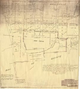
Map of planned Belleville Harbour
Parte de Map collection
A map showing a plan for the Belleville Harbour. The total area stretches from south Front Street to the Ponton Plan. Published by John T. Ransom on May 19th, 1947. The map features field notes of survey of lands, marshes and Bay of Quinte waters. Scale: 1':100'.
Sem título
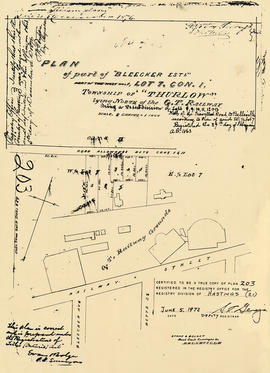
Plan of Bleecker Estate in the Township of Thurlow
Parte de Map collection
A certified reproduction of the "Plan of part of Bleecker Estate, part of west half of Lot # 7 in 1st Concession Thurlow.” The Estate lay north of the Grand Trunk Railway being a re-subdivision of Lots # 8, 9, 10, 11 & 13. Surveyed by Evans and Bolger, P. L. S. Plan registered February 27, 1863.
This copy was made in 1972 of plan #203, as registered in the Hastings Land Registry Office.
Donated by Walter I. Watson, P. L. S.
Sem título

Map of Sidney and Thurlow Townships
Parte de Map collection
This original map displays early township lots and proprietor names of Sidney and Thurlow Townships. Its date of creation is estimated to be between 1858-1863. Scale: 1:47,000.
Note that by observing the border, this map looks as if it was apart of a larger map. This is the only known copy.
Thurlow : Plan of Town lots in Canniffton, 1849
Parte de HCHS Textual Records collection: Files 2500 to 2999
File contains a copy of a sketch of town lots in Thurlow by Joseph Canniff in 1849. Also present are several photocopied survey maps by lot of Thurlow Township, ca. 1878.

Map of the Counties of Hastings and Prince Edward
Parte de Map collection
A "Map of the Counties of Hastings and Prince Edward." In 1898, the lots, concessions, churches, schools and mines are shown of the townships in Hastings and Prince Edward. Scale: 1.5 miles to an inch. Published by the Canadian Map Publishing Company in Hamilton, Ontario, for the Belleville Sun. Revised by Henry Carre, C.E. Inset is the map of North Hastings, scale 400 chains to an inch.
Sem título

Resources Map of Hastings County
Parte de Map collection
Resources map of Hastings County, Ontario, showing agricultural activity and natural resources.

Parte de Map collection
A map of the Township of Thurlow, in 1787. Contains names of local property owners within their respective lots. Surveyed by Deputy Provincial Surveyor Lewis Kotte. Scale: 40 chains : 1 inch.
Sem título

Subdivision of part Lot 3 in Thurlow Township
Parte de Map collection
A plan of subdivision of part of Lot # 3, Concession 2, Thurlow Township, property of William Bleecker. Surveyed by P. L. Surveyor John D. Evans and signed November 24, 1873. Scale two chains to an inch.
Donated by the Glanmore National Historic Site in 2016.
Sem título

Reproduced plan of Point Ann Railway
Parte de Map collection
A photocopy of the "Plan of the Point Ann Railway in the Township of Thurlow and County of Hastings and Province of Ontario." The area includes from the Grand Trunk Railway, Lots 13-16 Concession 1, Lots 16-19 Broken Front Concession and south to the Bay of Quinte. Originally printed January 17, 1903. Scale 400 feet to an inch. Surveyed by Henry Carre, O. L. S.
Donated by the Belleville Public Library in 2014.
Sem título

Map of Hastings with the Principal Villages and the City of Belleville
Parte de Map collection
A map of Hastings County including the Town of Belleville and other principal villages:
Trenton, Madoc, Marmora, Tweed, Bridgewater, Stirling, Wicklow, Bangor, Herschel, Monteagle, Carl, Dungannon, Wollaston, Limerick, Cashel, Tudor, Grimsthorpe, Elzevir; Rawdon, Huntingdon, Hungerford, Sidney, Thurlow, Tyendinaga.
Scale: 3 miles =1 inch. Published by Evans & Bolger, P. L. Surveyors, P.L.S. in 1879-1880.
Sem título

Plan of Tapson village in the Township of Thurlow
Parte de Map collection
A certified reproduction of the Plan of the village of Tapson on part of Lot # 8 in 3rd Concession Thurlow for Ann Tapson, widow of Ebsworthy Tapson deceased. Episcopal Methodist Parsonage on lot at north end. Saw Mill at south end of plot. Surveyed by John Emerson, P.L.S. and signed April 1, 1853.
This copy was made in 1972 of plan #44, as registered in the Hastings Land Registry Office.
Donated by Walter I. Watson, O.L.S.
Sem título
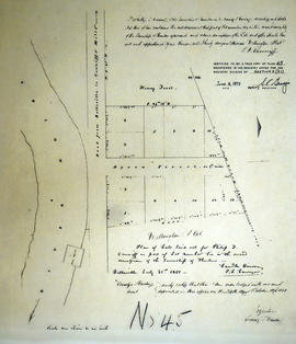
Plan of Wellington Plot in the Township of Thurlow
Parte de Map collection
A certified reproduction of the Plan of Wellington Plot. Lots laid out for Philip R. Canniff on part of Lot # 6 in second Concession Thurlow Township. Surveyed by Sameul Benson, P.L.S. and signed July 31, 1851.
This copy was made in 1972 of plan #45, as registered in the Hastings Land Registry Office.
Donated by Walter I. Watson, O.L.S.
Sem título
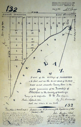
Plan of Planefield in the Township of Thurlow
Parte de Map collection
A certified reproduction of the Plan of Planefield in west Lot # 23 in 6th Concession, Thurlow Township, for proprietor William W. Fox. Surveyed by John Emerson, P.L.S. and signed September 1868.
This copy was made in 1972 of plan #132, as registered in the Hastings Land Registry Office.
Donated by Walter I. Watson, O.L.S.
Sem título