
Collage of topographical maps of Trenton area
- CA ON00156 2023-083
- Unidad documental simple
- 1933
Collage of pasted 1933 topographical maps of the Bay of Quinte region, with 'Wavecrest' property identified in ink.
Sin título
Collage of topographical maps of Trenton area
Collage of pasted 1933 topographical maps of the Bay of Quinte region, with 'Wavecrest' property identified in ink.
Sin título

Topographical Map of Belleville - Canada sheet
Parte deMap collection
A topographical map of Belleville - Canada sheet #31 C/3 (west half). Area extends from North-Honeywell corner to South-Conscecon Lake and from East- Hungry Bay to West [racist slur redacted] Narrows. Map was published by the Department of National Defence in 1950. Scale 1:50,000.
Sin título

Topographical map of Tweed - Canada sheet
Parte deMap collection
A topographical map of Tweed - Canada sheet #31 C/6. Published by the Army Survey Establishment, Department of National Defence in 1933. Scale 1 inch to 1 mile = 1/63,360.
Donated by Gerry Boyce.
Sin título

Topographical map of Tweed - west half
Parte deMap collection
A topographical map of Tweed - Canada sheet #31 C/6, west half. Published by the Army Survey Establishment, Department of National Defence in 1958. Scale 1:50,000.
Donated by Gerry Boyce.
Sin título

Topographical map of Tweed - east half
Parte deMap collection
A topographical map of Tweed - Canada sheet #31 C/6, east half. Published by the Army Survey Establishment, Department of National Defence in 1958. Scale 1:50,000.
Donated by Gerry Boyce.
Sin título

Topographical map of Trenton - Canada sheet
Parte deMap collection
A topographical map of Trenton - Canada sheet #31 C/4. Published by the Army Survey Establishment, Department of National Defence in 1938. Scale one inch to one mile - 1/63, 360.
Donated by Gerry Boyce.
Sin título

Topographical map of Mazinaw Lake
Parte deMap collection
A topographical map of Mazinaw Lake - Canada sheet #31 C/14. Published by the Army Survey Establishment, Department of National Defence in 1947. Scale 1 inch to 1 mile = 1/63.360.
Sin título

Topographical map of Duck Island
Parte deMap collection
A topographical map of Duck Island- Canada sheet #30 N/15. Published by the Army Survey Establishment, Department of National Defence in 1932. Scale one inch to one mile - 1/63, 360.
Donated by Gerry Boyce.
Sin título
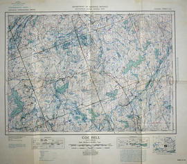
Topographical map of Coe Hill - east half
Parte deMap collection
A topographical map of Coe Hill- Canada sheet #31 C/13, east half. Published by the Army Survey Establishment, Department of National Defence in 1956. Scale 1:50,000.
Donated by Gerry Boyce.
Sin título
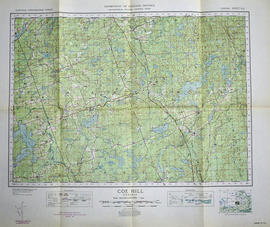
Topographical map of Coe Hill - west half
Parte deMap collection
A topographical map of Coe Hill- Canada sheet #31 C/13, west half. Published by the Army Survey Establishment, Department of National Defence in 1956. Scale 1:50,000.
Donated by Gerry Boyce.
Sin título
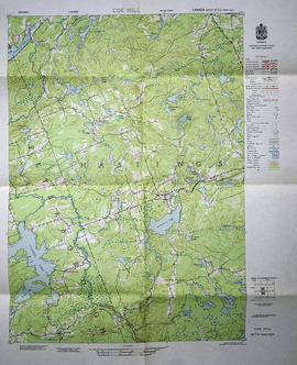
Topographical map of Coe Hill - Canada sheet
Parte deMap collection
A topographical map of Coe Hill- Canada sheet #31 C/13. Published by the Army Survey Establishment, Department of National Defence in 1950. Scale one inch to one mile = 1/63,360.
Donated by Gerry Boyce.
Sin título
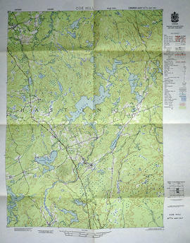
Topographical map of Coe Hill, Ontario
Parte deMap collection
A topographical map of Coe Hill- Canada sheet #31 C/13. Published by the Army Survey Establishment, Department of National Defence in 1949. Scale one inch to one mile = 1/63,360.
Donated by Gerry Boyce.
Sin título

Topographical map of Belleville - east half
Parte deMap collection
A topographical map of Belleville - Canada sheet #31 C/3, east half. Published by the Army Survey Establishment, Department of National Defence in 1956. Scale 1:50,000.
Donated by Gerry Boyce.
Sin título

Topographical map of Belleville - west half
Parte deMap collection
A topographical map of Belleville - Canada sheet #31 C/3, west half. Published by the Army Survey Establishment, Department of National Defence in 1956. Scale 1:50,000.
Donated by Tom Ransom.
Sin título

Topographical map of Bannockburn - Canada sheet
Parte deMap collection
A topographical map of Bannockburn - Canada sheet #31 C/12. Published by the Army Survey Establishment, Department of National Defence in 1950. Scale one inch to one mile - 1/63,360.
Donated by Vera Crabbe in 2008.
Sin título

Topographical map of Bancroft - east half
Parte deMap collection
A topographical map of Bancroft - Canada sheet #31 F/4, east half. Published by the Army Survey Establishment, Department of National Defence in 1956. Scale 1:50,000.
Donated by Gerry Boyce.
Sin título

Topographical map of Bancroft - west half
Parte deMap collection
A topographical map of Bancroft - Canada sheet #31 F/4, west half. Published by the Army Survey Establishment, Department of National Defence in 1956. Scale 1:50,000.
Donated by Gerry Boyce.
Sin título

Topographical map of Bancroft - west half
Parte deMap collection
A topographical map of Bancroft - Canada sheet #31 F/4, west half. Published by the Army Survey Establishment, Department of National Defence in 1950. Scale 1:50,000.
Donated by Gerry Boyce.
Sin título

Topographical map of Bancroft - east half
Parte deMap collection
A topographical map of Bancroft - Canada sheet #31 F/4, east half. Published by the Army Survey Establishment, Department of National Defence in 1950. Scale 1:50,000.
Donated by Gerry Boyce.
Sin título

Topographic Map of Ontario - Belleville Sheet
Parte deMap collection
A map from the Eastern Canada series entitled "Topographic Map of Ontario - Belleville Sheet 31 C/3." The map includes Hastings County to Hillier in Prince Edward County. Published in 1938 by the Department of National Defence. Scale 1 inch to 1 mile.
Donated by the Belleville Public Library in 2014.
Sin título