Mostrando 817 resultados

Descripción archivística
Land, settlement and immigration Imagen
Imprimir vista previa Hierarchy Ver :

817 resultados con objetos digitales Muestra los resultados con objetos digitales

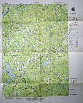
Topographical map of east Trenton - Canada sheet

  • CA ON00156 M/M440-1485
  • Unidad documental simple
  • Dec 1962
  • Parte deMap collection

A topographical map of Trenton - Canada sheet 31 C/4. Map was published by the Department of National Defence in December 1962.
This second edition was converted from the first edition of the 1:63,360 map to 1:50,000 by the A. S. E. in 1950.

Insets include:
1) legend
2) index to adjoining sheets
3) mean declination
4) grid reference on the sheet and other minor information.

Sin título

Topographical map of Bancroft - west half

  • CA ON00156 M/M470-1559 - 1573, 1576 - 1579, and 1585 - 1621/1561
  • Unidad documental simple
  • 1956
  • Parte deMap collection

A topographical map of Bancroft - Canada sheet #31 F/4, west half. Published by the Army Survey Establishment, Department of National Defence in 1956. Scale 1:50,000.

Donated by Gerry Boyce.

Sin título

Topographical map of Belleville - west half

  • CA ON00156 M/M470-1559 - 1573, 1576 - 1579, and 1585 - 1621/1572
  • Unidad documental simple
  • 1956
  • Parte deMap collection

A topographical map of Belleville - Canada sheet #31 C/3, west half. Published by the Army Survey Establishment, Department of National Defence in 1956. Scale 1:50,000.

Donated by Tom Ransom.

Sin título

Topographical map of Belleville - east half

  • CA ON00156 M/M470-1559 - 1573, 1576 - 1579, and 1585 - 1621/1573
  • Unidad documental simple
  • 1956
  • Parte deMap collection

A topographical map of Belleville - Canada sheet #31 C/3, east half. Published by the Army Survey Establishment, Department of National Defence in 1956. Scale 1:50,000.

Donated by Gerry Boyce.

Sin título

Topographical map of Coe Hill - west half

  • CA ON00156 M/M470-1559 - 1573, 1576 - 1579, and 1585 - 1621/1588
  • Unidad documental simple
  • 1956
  • Parte deMap collection

A topographical map of Coe Hill- Canada sheet #31 C/13, west half. Published by the Army Survey Establishment, Department of National Defence in 1956. Scale 1:50,000.

Donated by Gerry Boyce.

Sin título

Topographical map of Tweed - east half

  • CA ON00156 M/M470-1559 - 1573, 1576 - 1579, and 1585 - 1621/1616
  • Unidad documental simple
  • 1958
  • Parte deMap collection

A topographical map of Tweed - Canada sheet #31 C/6, east half. Published by the Army Survey Establishment, Department of National Defence in 1958. Scale 1:50,000.

Donated by Gerry Boyce.

Sin título

Topographical map of Tweed - west half

  • CA ON00156 M/M470-1559 - 1573, 1576 - 1579, and 1585 - 1621/1617
  • Unidad documental simple
  • 1958
  • Parte deMap collection

A topographical map of Tweed - Canada sheet #31 C/6, west half. Published by the Army Survey Establishment, Department of National Defence in 1958. Scale 1:50,000.

Donated by Gerry Boyce.

Sin título

Topographical Map of east Belleville - Canada sheet

  • CA ON00156 M/M470-1574
  • Unidad documental simple
  • 1962
  • Parte deMap collection

A topographical map of east Belleville - Canada sheet #31 C/3. Area extends from Tyendinaga Mohawk Territory to Lennox & Addington East to West and South to Picton Bay. Map was published by the Department of National Defence in November 1962. Scale 1:50,000.

Sin título

Topographical Map of west Trenton - Canada sheet

  • CA ON00156 M/M470-1623
  • Unidad documental simple
  • December 1962
  • Parte deMap collection

A topographical map of west Trenton - Canada sheet #31 C/4. Area includes the West Half of Trenton and part of Northumberland County. Map was published by the Department of National Defence in December 1962. Scale 1:50,000.

Sin título

Topographical Map of the Belleville to Kingston

  • CA ON00156 M/M470-1659
  • Unidad documental simple
  • 1935
  • Parte deMap collection

A topographical map of the area between Belleville and Kingston. The total area extends from Prince Edward County to Buckshoot Lake North & South and from Havelock to Smith Falls East and West. Dated 1935. Published by the Department of National Defense.

Donated by Eric Jones.

Sin título

Plan of Subdivision of Lot 2 in the town of Belleville

  • CA ON00156 M/M440-1669
  • Unidad documental simple
  • 30 Nov 1871
  • Parte deMap collection

A certified reproduction of the Plan of subdivision of Lot # 2 on the west side of Yeomans Street, as laid out on Block B in Belleville, being part of Lot # 1 in 1st Concession Thurlow, for Wellington, Murney and designated “Bulls Block”. Surveyed by John D. Evans, P.L.S. and signed November 30, 1871.

This copy was made in 1972 of plan #146, as registered in the Hastings Land Registry Office.

Donated by Walter I. Watson, O.L.S.

Sin título

Plan of Randolph Place in the town of Belleville

  • CA ON00156 M/M440-1675
  • Unidad documental simple
  • 11 Jul 1870
  • Parte deMap collection

A certified reproduction of Randolph Place, or a plan of 4 Lots, each ½ acre belonging to Ezro W. Holton - being part Lot # 6 in 1st Concession Thurlow now in Belleville. Depicted are the 2 large brick homes on Randolph Place lots # 1 and 2. Surveyed by Samuel M. Benson, P.L.S. and signed July 11, 1870.

This copy was made in 1972 of plan #136, as registered in the Hastings Land Registry Office.

Donated by Walter I. Watson, O.L.S.

Sin título

Plan of Planefield in the Township of Thurlow

  • CA ON00156 M/M430-1677
  • Unidad documental simple
  • Sep 1868
  • Parte deMap collection

A certified reproduction of the Plan of Planefield in west Lot # 23 in 6th Concession, Thurlow Township, for proprietor William W. Fox. Surveyed by John Emerson, P.L.S. and signed September 1868.

This copy was made in 1972 of plan #132, as registered in the Hastings Land Registry Office.

Donated by Walter I. Watson, O.L.S.

Sin título

Plan of Hawley's Survey of town lots in Village of Trenton

  • CA ON00156 M/M430-1679
  • Unidad documental simple
  • Jan 1871
  • Parte deMap collection

A certified reproduction of the Plan of Hawley's Survey of town lots in the Village of Trenton. Laid out on the southwest part of Lot # 1 in 1st Concession of Murray Township, designated “The Hawley Estate” for Josiah Hawley, proprietor. Surveyed by David Williams, P.L.S. and signed January 1871.

This copy was made in 1972 of plan #141, as registered in the Hastings Land Registry Office.

Donated by Walter I. Watson, O.L.S.

Sin título

Plan of VanBlaricom Burying Ground in the Township of Sidney

  • CA ON00156 M/M430-1689
  • Unidad documental simple
  • 30 Nov 1868
  • Parte deMap collection

A certified reproduction of the Plan of VanBlaricom Burying Ground - part of Lot # 10 in 1st Concession of Township of Sidney. Surveyed by John J. Haslett, P.L.S. and signed November 30, 1868.

This copy was made in 1972 of plan #127, as registered in the Hastings Land Registry Office.

Donated by Walter I. Watson, O.L.S.

Sin título

Plan of Ross Block in the Town of Belleville

  • CA ON00156 M/M440-1690
  • Unidad documental simple
  • 10 Apr 1869
  • Parte deMap collection

A certified reproduction of the Plan of Ross Block, part of the Estate of Hon. John Ross of Belleville. The block includes part of Lot # 5 in 1st Concession in Township of Thurlow and in the north half of Lot in the Town of Belleville. Surveyed by John J. Haslett, P.L.S. and signed April 10, 1869.

This copy was made in 1972 of plan #131, as registered in the Hastings Land Registry Office.

Donated by Walter I. Watson, O.L.S.

Sin título

Plan of South Hastings in the Township of Huntingdon

  • CA ON00156 M/M430-1692
  • Unidad documental simple
  • 27 Mar 1867
  • Parte deMap collection

A certified reproduction of the Plan of South Hastings laid out on Lot # 12, 14th Concession of Huntingdon, for Charles. Kirk. Surveyed by C. F. Ayslworth Sr., P.L.S. and signed March 27, 1867.

This copy was made in 1972 of plan #118, as registered in the Hastings Land Registry Office.

Donated by Walter I. Watson, O.L.S.

Sin título

Plan of lots in the Town of Belleville for Wm Dafoe

  • CA ON00156 M/M430-1699
  • Unidad documental simple
  • 26 Aug 1861
  • Parte deMap collection

A certified reproduction of the Plan of lots surveyed for William Dafoe in the Town of Belleville. Lots bounded by Mill Street, Dafoe Street and Coulter Street. Includes property owned by G. H. Meyers with “Meyer's Hotel” depicted. Surveyed by Samuel M. Benson, P.L.S. and signed April 26, 1861.

This copy was made in 1972 of plan #98, as registered in the Hastings Land Registry Office.

Donated by Walter I. Watson, O.L.S.

Sin título

Plan of village of Milltown in the Township of Tyendinaga

  • CA ON00156 M/M430-1705
  • Unidad documental simple
  • 1860
  • Parte deMap collection

A certified reproduction of the Plan of part of Lot # 10 in 1st Concession of "Tyandinaga" Township, south of Road and the vilalge of Milltown. Depicted: homes, foundry, grist mill, saw mill, forge wells, lkiln and bounded by the Grand Trunk Railway. Surveyed by J. J. Haslett, P.L.S. in 1860.

This copy was made in 1972 of plan #97, as registered in the Hastings Land Registry Office.

Donated by Walter I. Watson, O.L.S.

Sin título

Plan of Lots 26-29 in the town of Belleville

  • CA ON00156 M/M440-1708
  • Unidad documental simple
  • June 1864
  • Parte deMap collection

A certified reproduction of the Plan of Lot # 27 on the west side of Pinnacle Street, part of the north half of Lot # 28, part of the south half of Lot # 29 on the east side Front Street and Lot # 26. Lots were divided into 13 small lots of the estate of Late Rev. Thomas Campbell. Surveyed by Samuel M. Benson, P.L.S. in June of 1864.

This copy was made in 1972 of plan #108, as registered in the Hastings Land Registry Office.

Donated by Walter I. Watson, O.L.S.

Sin título

Resultados 61 a 80 de 817